I thought it best to walk the streets close to State Highway One when the roads were quiet so I was out walking early on Sunday morning. I walked 12 streets.
694. Queens Gardens
695. Anzac Square
696. Water Street
697. Jetty Street
698. Police Street
699. Jervois Street
700. Wolseley Street
701. Gordon Street
702. Vogel Street
703. Crawford Street
704. Bond Street
705. Rattray Street
My apologies if this blog post is a bit long, I walked past so much of Dunedin's history today that I just had to try and share some of it.
After walking in the suburbs yesterday, today I didn't see many views but the one view of note today is this view with the trees on the hill being the start of the Town Belt
I walked around the Queens Gardens which divides the two one way systems. Queens Gardens was originally named Victoria Gardens in 1904 after Queen Victoria but it wasn't long before the name Queens Gardens was adopted. There is a monument of Queen Victoria in the gardens.
In the centre of the Queens Gardens is the Cenotaph which commemorates the Dunedin members of the armed forces who died in the first and second world wars. The foundation stone of the Cenotaph was laid in 1924 and each year tens of thousands of people attend a dawn service here on Anzac Day, 25 April.
On the edge of the Queens Gardens is this Celtic Cross symbolising the city's first European settlers and built in 2000 to remind future generations of the arrival of the first Christian settlers.
I finished walking Rattray Street today, a street that I had started a while ago. Rattray Street took me to the Exhange which was the financial heart of Dunedin. In the Exchange is the Cargill Monument, erected in 1872 that commemorates William Cargill, who was the leader of Free Church migration to Otago and the first superintendent of the region. It was a versatile monument as it had a gas lamp, drinking fountain and viewing platform. Today there is no gas lamp and the fountain does not work but the viewing platform is still there.
I walked past a painted telephone cabinet today which shows the Cargill Monument in the exchange inf 1930. Other sides of the cabinet show more pictures of early Dunedin.
Also in the Exchange are three bronze penguins that stand about 60cm high. The penguins were donated in 1990 as public art.
On Cumberland Street, I walked past Toitu Otago Settlers Museum. Founded in 1898, 50 years after the first settlers arrived in Dunedin and originally called the Otago Early Settlers Museum it's main purpose was to preserve the region's early Maori history and the first gold rush history from the 1860's. Eventually the word 'early' was dropped and it's scope widened to incorporate all era's of history for Dunedin and Otago. Over the years the building that houses the Settlers Museum has grown, the latest part being built in 2012 and is shaped like the bow of a boat, to represent the sailing ships of the first settlers.
The newer part of Toitu is joined to the original building. This part of the building is home to portraits of the settlers who arrived on the first boats to Dunedin. There is no charge to enter Toitu and it is well worth a visit around all the galleries.
In 1994, the Early Settlers Museum was joined to the old bus station that was vacant next door. The art deco bus station was built in 1939 and now houses the transport part of the Toitu museum.
Between Toitu and the Railway Station is the steam locomotive JA1274. This is the last steam locomotive to have been built by the NZ Railway Hillside workshop in Dunedin so it seems fitting that it is still here in Dunedin. JA1274 was built in 1956 and has been displayed at the Early Settlers Museum since 1975. While the locomotive is no longer operational it is in very good condition and just needs the firebox re-bricked and the boiler checked and one day, it may possibly run the rails again.
Today I noticed these roses planed near the entrance to Toitu and of even more interest is the plaque nearby that explains that the roses are a cutting from the original plant that was bought from Esher, England in 1848 on John Wickliffe which is the first sailing ship to arrive in Dunedin.
My walk today took in so many historical buildings of the city and one of the is the Otago Daily Times or ODT. The ODT is New Zealand's oldest surviving daily newspaper with the first newspaper rolling off the press in 1861.
For many years Dunedin was home to the chocolate factory Cadbury. Dating back to 1868 when Richard Hudson arrived in Dunedin and started a bakehouse making biscuits and in 1884 he opened the Southern Hemisphere's first chocolate factory. Often there was the smell of chocolate in the air surrounding the factory until it's closure in 2018. The Cadbury factory is currently being demolished to make way for the new Dunedin Hospital. This photo shows the original Cadbury building and the purple silo was the one used for the chocolate waterfall that was part of the Cadbury factory tour.
Part of my walk today took me back past the Railway Station as I walked circumnavigated Anzac square. I know I put a picture of the railway station on my blog a couple of days ago but the railway station really is impressive and it is easy to see why it is the most photographed building in New Zealand.
The garden area outside the Railway Station is known as ANZAC square, named after the Australian and New Zealand Army Corp and is a remembrance for the soldiers who served in the 1914-1918 war.
In the late 1800's and early 1900's railway was the main form of transportation for people and goods, the goods yard and track covered a large area of land. One way to cross this area was by a bridge that was built in 1883 and it was in use up until 1977 when it was replaced with the new Jetty Street overbridge. This old bridge was significant in two ways - one is that it was the first bridge to use commercially produced New Zealand steel with steel that was made in Green Island, and the second is the length of the bridge being 196 metres. This is what the rail yard and the bridge that crossed it looked like.
And this is the 'new' Jetty Street bridge that was built in 1977 to replace the old railway overbridge. It is much larger and higher with on and off ramps. Note there is not much traffic but that is because I was walking early on a Sunday morning.
The old bridge is gone but the stone abutments remain. The stone abutments are nondescript and show nothing of their history. I have often passed here in a car and have not really taken any notice of them. It was not until I walked past that I stopped to investigate.
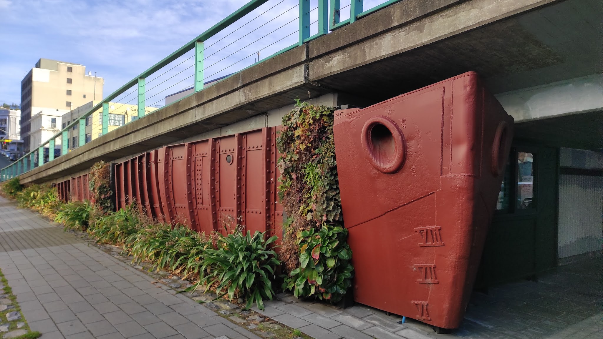
Attempts have been made to 'beautify' the Jetty Street overbridge
with the abutment decorated with a hanging garden and made to represent
an old ship. Again this is something that I would not have seen had it not
been for my challenge to walk every street.
Another place of interest that I walked past today is Lan Yuan Dunedin Chinese Garden. This is the only authentic Chinese Garden in New Zealand and is only one of three outside China. It was built by workers who came from Shanghai specifically to build the gardens. The garden was opened in 2008
During my walk today I learnt that Dunedin was home to New Zealand's first skyscraper. The New Zealand Express Company building, now known as Consultancy House is the concrete building in right of this photo. It is seven stories and was built in 1908. It is also the first building in New Zealand to use pre-cast concrete slabs constructed off-site. This photo shows how much taller it is than it's neighbours of the same era.
I am often surprised at what I see while walking and today I walked over the stone that marks the spot where the John Wickliffe bringing the first settlers to Dunedin landed. Today this stone is a long way from the harbour area but in the 1800's it was part of the foreshore, hence the surrounding street names of Water Street, Wharf Street and Jetty Street.
This is the view from the first landing site and all the land that the buildings are on came from Bell Hill and where First Church is now standing. Bell Hill divided the city in two and in the 1870's it was removed and the fill was used to reclaim a lot of the land that you can now see. Without this reclaimed land, Dunedin would be a very different looking city.
The Warehouse Precinct is one of the older parts of the city and as a result there are many lovely, old restored buildings. Most of these buildings have been built on land that has been reclaimed from the removal of Bell Hill.
And finally I will show some of the street art that I walked past today. I have walked past much street art in the central city over the last couple of weeks and it is great to see blank, unremarkable walls transformed into works of art. An added benefit of the art is that it removes and keeps away unsightly graffiti.
Distance walked: 8.9 km Walking time 1 hr 34 mins
Total distance: 444.7 km Total walking 83 hr 40 mins