Showing posts with label war memorial. Show all posts

Sunday, December 18, 2022

#19 of 100 trips - Gardens / Upper Junction / Blanket Bay / return to Dunedin Gardens 17 December 2022

Five intrepid trampers met at the Gardens corner to recreate one of the early tramping trips of the Otago Tramping Club which involved a lot of road walking which, for the early trampers, would have been on narrow, winding gravel roads but for us was on mostly narrow, winding sealed roads and a wide, flat, smooth cycleway.   We were quietly confident that the sea fog would lift by the time we had reached Upper Junction so that we would be able to see the views, little did we realise how wrong we were.  Meeting at the Gardens corner we set off walking up North Road towards Upper Junction.
The first two and a half kilometers has only a mild gradient and the time went quickly as we walked and chatted our way up North East Valley.  Once we reached Normanby the gradient increased and the sea fog seemed to come lower down the hill so that it felt like it wouldn't be long before we walked into it.  It was a nice surprise to meet my father out for his morning walk and we stopped for a brief chat before continuing on.  Only a short distance on the footpath ran out and we were walking along the edge of the road. 
One of the reasons for the early start to the walk was to avoid the traffic on this part of the road and for the most part it worked with only spasmodic traffic. The higher we climbed the thicker the fog became and by keeping well to the side of the road, we didn't disrupt any traffic.  One of the good things about road walking is that the slower pace means that you get time to see things that you'd normally miss when driving past which is exactly what we did - chatting to passing cyclists, listening to the birds, spying bugs in the long grass, watching the sheep and cows (who were watching us), admiring the flowers and our most unusual find was one new, unused boot. 
The higher we climbed the thicker the fog/mist became so that when we reached the highest point at Upper Junction, disappointingly there was no view.  Instead of admiring the view of North East Valley and the city that was hidden to us, we took a small detour to visit the war memorial on the site of the former Upper Junction School that was destroyed by fire in 1945.  There are 17 beech trees planted beside plaques in remembrance of former pupils who were killed during the first world war. This is a particularly poignant war memorial for me as my fathers uncle has a plaque and beech tree planted in his memory here.  John Williams was 17 when he signed up, lying about his age so that he would be accepted into the army and killed at the Somme, aged just 19 years.  It seemed very fitting with the muted light from the  mist swirling around the hundred year old giant macrocarpa trees creating an ethereal atmosphere during our visit of this site.
What goes up must then come down and that is exactly what we did, heading 300 metres down hill on Upper Junction Road, all the way to sea level.  It seemed almost impossible but the mist seemed to grow thicker and we were barely able to see each other at times.  The striking views were non-existent so had to keep an ear open for cars to avoid being hit on the narrow, winding road.
As we dropped lower the mist slowly started to thin until we dropped below it and finally got our first views of the surrounding farmland and down to the harbour. We stopped on a sweeping bend where we could get well off the road for a morning tea break.  Replenishing ourselves with a drink and snack while admiring all that we could see.  With the hills on the opposite side of the harbour and most of the city being shrouded in fog, we were only able to see down to Blanket Bay and Roseneath. 
Knowing that most of the hill was behind us, we continued down the hill where we eventually met up with the main road to Port Chalmers, State Highway 88.  We admired the yet to be completed new cycleway/walkway including the blue surface from a distance. Despite the cycleway looks like it is completed, there are large fences stopping access  so we continued walking along St Leonards Drive.
A lunch stop was called at St Leonards Park where Mandy found a swing to sit while the rest of us opted for the picnic table.  Lindsay arrived with his dog and a box of cherries which he shared while we watched a large ship sail past on it's way to the inner harbour.  By now we were over halfway through our walk and were about to start on the 'easy' part of our walk, along the flat cycle/walkway which runs beside the railway line.  This proved to be more difficult than first thought as the 8km of flat, hard surface made for tired legs and feet.  The fog was lifting with the views of the harbour opening out and we were able to distract each other by seeing who could spot the most interesting sight.  Some of the interesting things we saw were kayakers getting tooted at by the harbour tug for being in the main shipping channel, swimmers jumping off the harbour channel markers, a speedboat jumping the tug boats wake, a grey spoonbill, a few sad, rotting boats, some exercise equipment, lots of walkers and only a handful of cyclists but no trains. 
Once we reached the stadium we turned off the cycle/walkway and continued past the University, skirted around a cricket match in progress and wandered through the student housing until we reached the Water of Leith. We followed the Water of Leith through the Gardens and back to the main gates where we had started 5.5 hours and 21km earlier.

Tuesday, December 14, 2021

Day 124 Normanby

Today I completed the last few streets in my challenge to walk every street in Dunedin. I walked 8 streets today.

1680. North Road
1681. Ribbonwood Close
1682. Cleghorn Street
1683. Corsall Street
1684. Clava Street
1685. Nisbet Street
1686. Norwood Street
1687. Potters Road
1688. Cotter Road

While walking the streets, yesterday I looked across the harbour to see Mt. Cargill.  Today I walked the streets that would take me closest to Mt. Cargill.  I grew up with this view of Mt. Cargill. 

My walk today took me up the hill and I was able to look down to the streets at the bottom of the hill.  My plan for today's streets is taking me on a large loop and I will be finishing my walk on the street at the bottom of this hill.


As I walked further up the hill, Mt. Cargill (hill on the left with the transmitter) got closer and I was able to see how much further up I had to walk.  The group of trees on the skyline in the middle of the picture is as far up the hill that I needed to walk.
Today I was walking on the northern edge of the city and could look back over farmland.  At the bottom of the field is the Forrester Park sports fields that include a dog park and BMX track.  This used to be an old city dump and was covered over to create recreational facilities for the city many years ago.

As I walked around the side of the hill, I could look back over the northern part of the city.  From here, I was able to see the town belt easily.  The town belt is the 'belt' of trees through the middle of the city.  The town belt was planned in Scotland around 1848 and is one of only three town belts in the world. It is an example of the native bush that would have covered the hills before the settlers arrived and the city was built.

I walked a number of short side streets today and one of those side streets took me around the hill to a view of the harbour and the hills of the peninsula.  I was able to look down to where I was walking yesterday, around the road at the base of the hills.  This view was a nice surprise. 

Then I was back to the main road and onto the top of the hill.  This is as close to Mt. Cargill as I got and from here it is easy to see why the Maori legend tells of  Kapukataumahaka /Mt. Cargill being a warrior lying down.  Mt. Cargill has the transmitter on the top and is the body of the warrior while Buttars Peak to the right is the head with the legs of the warrior to the right of Mt. Cargill.


As I reached the top of the hill, I had one final view of the city before I walked down the hill to the street at the bottom (in the middle of this picture).  I had started walking from this street and walked up the hill around the left before walking down on the right back to where I started walking.

The road down the hill was a lot steeper and narrower than the one that I had walked up.  This road is mainly used by the local farmer but it made a nice loop to walk and had houses near the bottom.

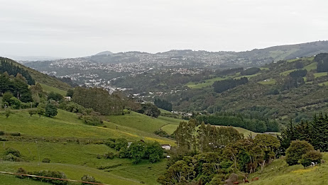
The final view I had was at the bottom of the hill, looking back up to where I had walked earlier.  The houses in the middle of the hill are on streets that I had been on as I walked up the hill.

 
One place of interest that I walked past today is the Upper Junction School war memorial. The large macrocarpa trees were part of the school grounds and there has been a lot of work done recently to tidy the once overgrown site.
There is no school here as it was burnt down in 1945 but the war memorial site is still maintained   The memorial is for seventeen former pupils of the school who were killed during the first world war.

This memorial site is of particular interest to me as one of the memorials is for my fathers uncle who died aged 20 during the first world war.  A beech tree has recently been planted beside each memorial. 

 
At the view of the harbour, I saw how some enterprising locals have made their own seats and bar leaner.  I could see how this would be a great spot on a warm summer evening with a glass or two to drink. 

There were only two interesting letterboxs that I walked past today.  I really liked that it is shaped like the house that it belongs to and I thought the microwave was a good letterbox was a good use for something that was no longer needed. 


Distance walked:  8.4 km         Walking time  1 hr 40 mins    

Total distance: 1032.7  km          Total walking  189 hr 53 mins 

Saturday, October 2, 2021

Day Ninety Five Waikouaiti

Today I headed back to finish walking the streets of Waikouaiti and I walked 18 streets.

1255. Inverary Street
1256. Nairn Street
1257. Dumbarton Street
1258. Haddington Street
1259. Inverness Street
1260. Greenlaw Street
1261. Matanaka Road
1262. Rothesay Street
1263. Cromarty Street
1264. Perth Street
1265. Clackmann Street
1266. Cupar Street
1267. Forfar Street
1268. Edinburgh Street
1269. Glasgow Street
1270. Gill Street
1271. Victoria Street
1272. Main Road

In Waikouaiti today, I was walking the streets on the other side of the lagoon and race course.  These streets are more rural and are similar to other streets in Waikouaiti as some are long and straight.
These roads skirt around the furthest edge of the Hawksbury Lagoon.  This is the lagoon that I had been walking on the other side during last weekend's walk. 
 
As happened last weekend I eventually walked all the way to the beach.  This beach is 4km in length and is the landing place of  'The Magnet' in 1840 . 

There were only a few people at the beach today and I was lucky to see this horse being exercised on the beach by it's jockey.
 
I walked past the golf club at Waikouaiti.  This is a small golf course with only 9 holes and was started in 1935. Because the course has a sand based surface, golf can be played all year round, regardless of the weather. 
 
After the golf course, I walked past the race course.  I had seen the race course from a different angle last weekend and I remember coming here with my family when I was a child.  The race course no longer has any meetings and is looking run down, especially the grandstand.
One of the last things I walked under while on my way back to where I started is this war memorial arch built over the footpath by Post Office Creek.  This memorial has 41 names on it of people from the area who did not come home from war. 
 
On my walk today, I walked past another entrance to the Hawksbury Lagoon.  I have enjoyed seeing the lagoon from different angles and I would like to come back and explore it further.
I was surprised to walk past this sheep and her lambs as the sheep had literally given birth to the two lambs minutes before I arrived.  I watched as the lambs stood for the first time and then took their first steps to their mother for feeding.
 
Walking on the rural side of town today, I walked past many animals.  A lot of houses had horses and sheep with a few cows and the odd pig as well.  These friendly horses were grazing on the side of the road.
 
And lastly, I have included the map of the streets that I have walked in Waikouaiti.  The streets that I completed today are on the right near the racecourse and towards the beach.  The other streets I walked over two days last weekend.

Distance walked:  9.8 km         Walking time  1 hr 49 mins   
 
Total distance: 781.3 km          Total walking  146 hr 27 mins 

Saturday, September 4, 2021

Day Eighty Three Steepest Street in the World

Dunedin is home to the world's steepest street and today was a bit of a milestone as I got to walk Baldwin Street.   I walked 26 streets today.

1026. Blacks Road
1027. Gillespie Street
1028. Royston Street
1029. Marquis Street
1030 Balfour Street
1031. Mowat Street
1032. Farquharson Street
1033. Roxburgh Street
1034. Grey Street
1035. James Street
1036. Longworth Street
1037. Primrose Bank
1038. Dalmeny Street
1039. Calder Avenue
1040. Buchanan Street
1041. Baldwin Street
1042. Felix Street
1043. Pentland Street
1044. Coburn Avenue
1045. Selwyn Street
1046. Paisley Avenue
1047. Calverley Street
1048. Lazar Street
1049. Carr Street
1050. Scone Avenue
1051. Jura Street

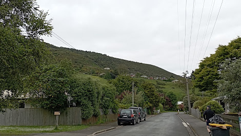
Today was another day where I was walking up and down the streets on the hill side of North East Valley. I started my walk up Blacks Road which goes from North East Valley up to Opoho and is very steep. 

The only good thing about Blacks Road is that it has a number of short streets off it which were a good opportunity for a bit of a rest and time to catch my breath. These streets also gave me a chance to see the view of North East Valley open up below me.

Of course what goes up must also go down and that was the story for most of my walk today.  The streets became steeper the closer I got to Baldwin Street.  Some of the streets are sealed with concrete because asphalt  or chip seal would melt and flow down the hill on a warm day and also for safety in Dunedin's frosty winters.

Baldwin Street has been measured and confirmed as the steepest street in the world.  While the bottom part of Baldwin Street has a gentle gradient, the upper part is very steep with a gradient of 1:2.86 which means that for every 2.86m traveled it climbs 1m in height. 

For those who make it to the top of Baldwin Street, there is a seat to sit and rest while admiring the view.  

 And once I was back at the bottom of Baldwin Street, I was able to look back up the hill, knowing that I had completed the steepest streets in world.
 
During my walk today, I walked past the North East Valley School gates which are a war memorial which commemorates former school pupils who were killed during the wars.  The soldier on the top was taken down many years ago as an earthquake risk and in 2007 it was returned to the top of gates.
Just along the road from the war memorial gates is the North East Valley Post Office which was built in 1914 and was in operation until 1988.  In more recent years the building has been a coffee shop. 
 As Baldwin Street is the steepest street in the world, it is a popular street to walk up by tourists and locals.  Often you can see people running up the street.  At the top of the street, there are these plaques commemorating some of the more unusual ways of getting up the streets. 

This photo shows how steep Baldwin Street.  The house is not built on an angle but this photo is taken to make the street look flat. 

I saw some more great street art on my walk today.


On my walk today, I saw two unusual letterboxes.  This cute red one and the other is propped up by an old chair. 

Distance walked:  9.0  km         Walking time  1 hr 48 mins  
 
Total distance: 670.1 km        Total walking  125 hr 26 mins 

Otago Harbour Cycleway 30 October 2023

With my sister in town, it seemed a shame to waste a calm, sunny day so the two of us hopped on a bike each to enjoy the recently opened 32k...