Sunday, April 25, 2021

Day Sixty North Dunedin

 Today was a longer walk around the streets surrounding the central city and University.  I walked 21 streets today. 

727. Albion Lane
728. Cumberland Street
729. Malcolm Street
730. Walsh Street
731. Emily Siedeberg Place
732. Claredon Street
733. Gowland Street
734. Castle Street 
735. Bow Lane
736. St Andrew Street
737. St Andrew Street Extension
738. Hanover Street
739. Frederick Street
740. Vire Street
741. Grange Street
742. Leith Street
743. Hyde Street
744. Ethel Benjamin Place
745. Ethel McMillan Place
746. Albion Street
747. Riego Street

Today I carried  on walking along the flat so there aren't many views to see but there continues to be many places and buildings of interest.  The first building of note that I walked past today was the Dunedin  Hospital.  The hospital has been on it's current site for more than 150 years with the first patient being admitted in 1866. Over the years the hospital has grown and this is one of the 'newer' building additions to the hospital, this ward block was built in 1983.

The Dunedin Hospital is set to move with the demolition of the Cadbury chocolate factory a few blocks south.  The new hospital is expected to cost more than 1.4 billion dollars and take 10 years to build I walked past the site of the new hospital today and can see where the demolition of the Cadbury chocolate factory has begun . 

Across the road from the current Dunedin Hospital is the Dunedin Medical School which was built in 1927.  The first fully trained doctor graduated from the Dunedin Medical School in 1887 and it was not until 1896 that the first woman doctor graduated.

 
The first woman to graduate from the Dunedin Medical School was Emily Siedeberg.  Emily faced hostile opposition when she enrolled at the medical school and went on to become the first female medical practitioner in New Zealand.   Today I walked the street named after her.  Emily Siedeberg Place is a small street between the University of Otago and the Dunedin Hospital.  There is a plaque in the footpath of the street to commerate Emily Siedeberg. 

Next to the medical school is the Otago University's pathology department and is home for the preventive medicine, pathology and bacteriology departments. This lovely art deco building was opened in 1948.

Next to the Dunedin Hospital is the old Queen Mary Maternity Hospital which opened in 1937 and closed in 1990 when it was amalgamated with the Dunedin Hospital.  Today it is a residential college for students studying at the University of Otago

Near the Dunedin Hospital, is the University of Otago School of Dentistry.  Founded in 1907, this is the only School of Dentistry in New Zealand and is ranked within the top 15 dental schools in the world.  Dunedin citizens are able to receive low cost dental treatment by trainee dentists at the dental school.

Today's walk has taken me past many buildings of significance and the last one that I will share is the Central Dunedin Fire Station.  Built in 1931, it originally housed the firemen and their families as well as the engines and equipment.  While the fire station is still in use today, the firemen no longer live or sleep at the fire station. 

Today I walked along part of Anzac Avenue which seemed very appropriate as today is Anzac day.  Anzac (Australia New Zealand Armed Corps)  is the day that we remember all the soldiers who did not come home from war.  Anzac Avenue was built on reclaimed land in 1925 and planted with elm trees. 

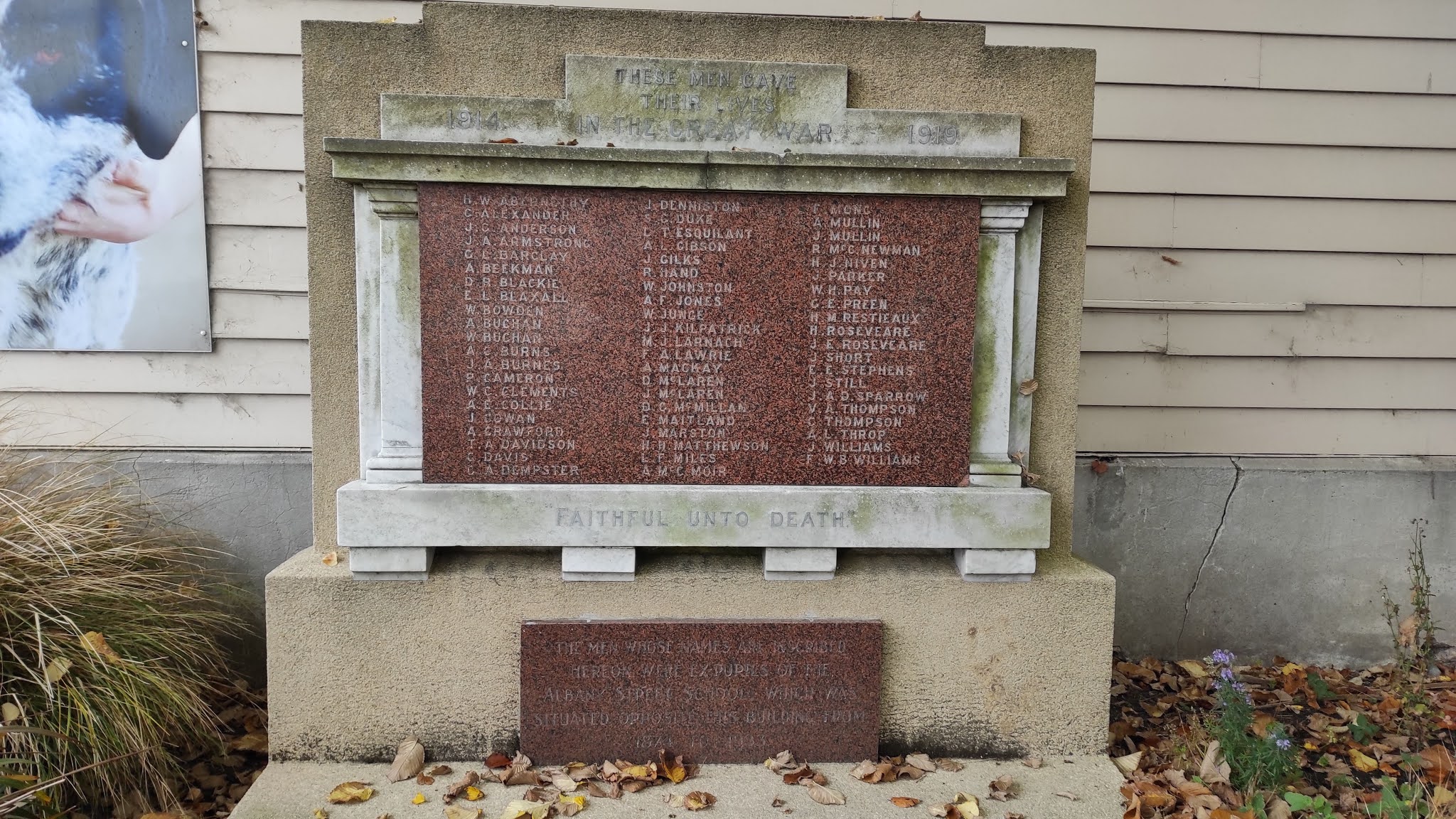
 I was pleased to walk past this hidden Anzac memorial today.  Hidden under a tree on the University of Otago art department grounds, this memorial is for all the men who were ex-pupils that gave their lives in the Great War of 1914-1919

I have already mentioned walking Emily Siedeberg Place which is a street named to commemorate the first New Zealand female doctor.  There are two other streets that I walked today that are named for other notable females.  One is Ethel Benjamin Place, named after Ethel Benjamin who is the first woman to qualify as a lawyer in New Zealand.  Ethel enrolled at the University of Otago in 1893 not knowing if she would be able to practice law once she graduated as women were not allowed into the legal profession at that time.  Ethel received top marks and in 1897 was admitted as a barrister of the Supreme Court of New Zealand

Ethel McMillan Place is the other street I walked that commemorates a notable female.  Ethel McMillan graduated from the University of Otago in 1926 and she was the first female to be elected to the Dunedin City Council where she served for 30 years.  Ethel went on to become the first woman elected to  New Zealand parliament where she served for 25 years. 

As I continue my walk around the streets surrounding the CBD, I come across more public art with these painted buildings.  


 Distance walked:  13.1 km      Walking time   2 hr 11 mins    

Total distance: 477 km       Total walking  89 hr 19 mins 
 

Saturday, April 24, 2021

Day Fifty Nine Studentville

My walk today took me around the streets surrounding the University of Otago past many of the student flats.  Today I walked 10 streets.

717. Ellis Street
718. Howe Street
719. MacKenzie Street
720. Moat Street
721. Brook Street
722. Castle Street North
723. Leith Street North
724. Montgomery Avenue
725. Union Street West
726. Union Place

I walked around the North Ground which is a sports field between the two one ways in the north end of Dunedin.  The autumn colours look great at this time of the year.

I walked over the Water of Leith again and followed it around behind the student flats and the side of the Dunedin Botanic Gardens.  The Water of Leith, also known as Ã’wheo, is contained by concrete sides which help contain the river during heavy rain and flooding.  Today it is flowing peacefully. 

Once past the student housing, I walked the streets that connected the University of Otago with the city.  The University of Otago accepted it's first students in 1871 making it the oldest university in New Zealand.  The University clock tower is the most recognisable building on campus and features in many graduation photos.

While there are parts of the university that date back to it's beginning, there are also newer buildings that have been added as the university has grown.  It is interesting to see how the different styles fit together.  Within sight of the stone cock tower is this modern glass building. 

The Water of Leith flows through the heart of the University of Otago where there has been a lot of work done on flood protection over the years. 

 Today on my walk I past the Otago Museum which was opened in 1868 and over the past 150 years, the museum has one of the largest museum collections in New Zealand with over 1.5 million objects.  The museum houses artifacts not just from New Zealand but from around the world including an Egyptian mummy, complete whale skeleton, animal attic and live butterfly house.  

Near the Museum is the historic North Dunedin Post Office which was built in 1878.  When the post office moved across the road, the museum took over the lease of the building and it often houses special exhibitions. 

One lovely old building that I walked past today is Selwyn College which was opened in 1893 and is Otago's first residential college. It was not until 1983 that women were allowed to live at the Selwyn College.

Students at the University of Otago are affectionately known as "scarfies" and this name dates back to the 1960's when it was common for students to wear long scarfs often because their flats were so cold.  In the 1930's students began naming their flats and today that tradition is still alive with over 600 weird and wonderful names.  Flats are often known by their names rather than their address.   Below is just a few of the named flats that I walked past today. 


One notoriously named flat  that I walked past today is 660 Castle Street.  This is where the New Zealand band Six60 was formed in 2008.  The founding members of the band were all flat mates in 660 Castle Street and they took their name from the address of their flat. 

There is some impressive public art in and around the student flatting area.  The paintings cover whole walls and are great for covering up walls that were prone to graffiti.   

There is also some graffiti on the sides of the concrete walls containing the Leith.  Some of the graffiti is very well done so while it is not official art, I thought it was worth taking a photo of.

Finally I thought I would share the google earth image of the streets that I have walked so far.  I have walked all the streets in red.

Distance walked:  7.8 km      Walking time   1hr 23 mins    

Total distance: 463.9 km       Total walking  87 hr 08 mins 
 

Friday, April 23, 2021

Day Fifty Eight Leith Valley

 I've had a week off walking the streets and was back today walking 5 streets.

712. Duke Street
713. Rockside Road
714. Clarewood Avenue
715. McGlashan Street
716. Woodhaugh Street
 
I started by walking Duke Street then I took the Bullock Track up the hill.  The Bullock Track is a cliff side path that cattle were lead along on their way to the works in the early days of  Dunedin.  Now there are no cattle but the pathway is still known as the Bullock Track and is a steep climb from Woodhaugh to Maori Hill.  The views from partway up the Bullock Track look towards Pine Hill and are worth a rest stop. 

I have already walked the streets of Maori Hill but I wanted to carry on walking Burma Street which winds it's way through the town belt and around the Ross Creek Reservoir. 

I walked only part of Burma Street before taking a short cut through Ross Creek Reservoir to meet up with Rockside Road.  I will walk the rest of Burma Street another day.  Ross Creek Reservoir is one of the oldest artificial lakes in New Zealand and was created in 1867 to provide water for the city of Dunedin.  It is the oldest water supply reservoir still in use in the country. Ross Creek Reservoir is surrounded by native bush and has many walking tracks and is a haven for birds.

Once onto walking Rockside Road, I followed it down the hill to Leith Valley.  The views from Rockside Road are a good place to see the town belt with the houses nestled amongst the trees.
The bottom of Rockside Road was a good place to look back up the hill where I had walked down to see the colours of Autumn putting on a good show on the hillside.

I walked over the Water of Leith twice on my walk along Malvern Street, crossing it in different places on my way back to where I had started my walk.  The Leith starts near the Northern Motorway and flows down Leith Valley and through the Unversity of Otago before reaching the harbour. 
Most of the time the Water of Leith is a quiet stream, however during heavy rain and steep sides, this quiet stream becomes a roaring river. Over the years there have been a series of engineering modifications along the length of Leith in an attempt to control the flooding. 


While I did not complete many streets on my walk today, I walked past a number of interesting areas.  I walked past the site of New Zealand's first paper mill today.  The Otago Paper Mills Company was established on this site in 1876.  The factory was destroyed by fire in 1911 and was rebuilt but eventually closed in 1936.  A camping ground is now on the site. 

I walked past some interesting pieces of art today.  This one is on the side of a garage near the Water of Leith.  It shows the river with a morepork. 

More art I walked past today was at the Ross Creek Reservoir.  In 2010 cracks were discovered in the reservoir.  The base of the dam was strengthened and the dam face was rebuilt and an artwork has been installed on the dam face.  

The artwork is a sculpture of 77 steel stars with the inspiration being the night sky reflecting in the water of the reservoir.  The stars have been placed to represent the southern constellations. 
 
 
There were a number of interesting buildings that I noticed on my walk.  The Woodhaugh Hotel is on the corner of Woodhaugh Street was a hotel during from 1882-1893.  It has been a restaruant, a brothel and now is a student flat.

I walked around this lovely old stone cottage that has a street on three sides with the house taking up the whole section. 
Another interesting building that I walked past is this old church that is now home to the NZ Deer Stalkers Association and the Dunedin Rock and Mineral Club.

Distance walked:  5.3 km      Walking time   59 mins    

Total distance: 456.1 km       Total walking  85 hr 45 mins


Otago Harbour Cycleway 30 October 2023

With my sister in town, it seemed a shame to waste a calm, sunny day so the two of us hopped on a bike each to enjoy the recently opened 32k...