Showing posts with label Dunedin. Show all posts

Monday, December 12, 2022

#16 of 100 trips for 100 years - Tunnel Beach 8 December 2022 (by Jade Pettinger)


This day trip was in place of a club Thursday night talk and is part of the 100 trips because the third weekend of the Otago Tramping Club in 1923 included two trips from the St Clair tram terminus to Blackhead via Cargill’s Castle. Similar trips appeared sporadically through the trip programme up until 1983, but urbanisation and more private owners of the land now make the original trip impossible and hence this trip was added to the 100 trip list.  

Being a windy evening and with the threat of rain, it was very heartening to see 19 people turn up at 6pm for the 1km wander 150m down the hill to Tunnel Beach. It was a reasonably fast walk down with a short stop for a team photo.

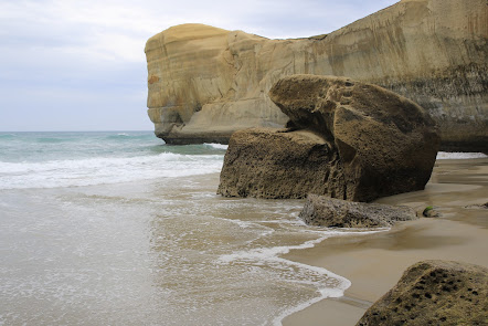
 The magnificent sculptured sandstone cliffs and arches provide a stunning backdrop for the turbulent waves that slam into the cliffs.  It's an impressive place to be to see how ferociously the waves are thrust into any small crevices in the rock, creating a larger crack which eventually breaks off from the main cliff.  There was plenty of evidence of the power of the water with large slabs of sandstone littering the base of the cliffs and  billowing plumes of water crashing into the rugged cliff face.

Turning our attention away from the surging sea we descended the 72 steps down the hand carved tunnel that gives Tunnel Beach it's name.  The tunnel was commissioned by a local politician, John Cargill  in the 1870's for his family to access their own secluded beach near the family home of Cargills Castle.  The tunnel is sloped and steep but easy to navigate and at the bottom we were rewarded by being able to see up close some of the large sandstone boulders that had fallen from the surrounding craggy cliffs. The boulders are a variety of  shapes and sizes with most being easy to clamber up onto. 

The tide was on it's way out so more sand was slowly being exposed and if you were quick, you were able to run around a small headland to a sheltered cave without getting wet.  A few people were not quite as quick as they should have been and ended up with wet feet. The cave is also a favourite overnight retreat for sea lions and some of our group were lucky to see one come surfing into the safety of the cave. 
All too soon it was time to retrace our steps back up through the tunnel and then continue following the track up the hill.  The climb up the hill was much slower than the descent but we all made good time, with only the occasional short rest and arrived at the cars about 1 hour after leaving.  
Written by Jade Pettinger

Monday, November 28, 2022

#12 of 100 trips for 100 years - Tomahawk to Highcliff 26 November 2022

This day trip is one that was first completed by the Otago Tramping Club on 6 October 1923. 99 years later, a group of 8 OTMC members met to recreate this early OTC trip, which is predominately a road walking trip over what would have been gravel roads and is now sealed. Starting at the old tram terminus (junction of Silverton, Highcliff and Tomahawk Road), we followed Tomahawk Road around to the Andersons Bay Cemetery where we took a detour through the cemetery before rejoining Tomahawk Road to cross the bridge and then take another detour onto Tomahawk Beach.
With the tide out there was a large strip of exposed sand and very few people which made for very pleasant walking. All too soon the beach came to an end and we headed up through the soft sand dunes to the Ocean Grove playground, where we again rejoined Tomahawk Road and then onto Centre Road. Now the fun part began as we started the steady climb up Centre Road. There was much to see on Centre Road, from admiring the old stone cottage, marvelling at the windswept trees, checking out the sections for sale, patting the horses and looking behind at the vast ocean. 
It's a climb of about 200m over nearly 3km and with very little traffic we were able to walk and chat in pairs and in small groups which made the climb pass very quickly. Once we reached the top of Centre Road and onto Highcliff Road we were rewarded with our first views of the Otago Harbour. We spent a few minutes looking across the harbour to Signal Hill and the Burns Reserve which is where we'd been nearly a month ago for trip #4/100 trips. 
A short walk along Highcliff Road and we took another short detour up the hill to the Soldiers Monument with panoramic views of the harbour, Mt Cargill, Dunedin City and Saddle Hill. It is not often that there is no/very little wind at the monument and we made the most of this rare opportunity by having a break and refueling with snacks and a drink. From the Soldiers Monument it is all down hill, following Highcliff Road back to the junction with Silverton Street and Tomahawk Road, where we had started 11 km and 3 hours earlier. 
Despite being a road walking trip, it ticked all the boxes 
  • great social trip by being able to walk and talk with others more easily on a sealed road 
  • wonderful views of our harbour that are often only glimpsed when traveling by car 
  • exercise with a 200+m climb and time to notice things we'd not seen before 


Tuesday, November 8, 2022

#5 of 100 trips for 100 years - Silver Peaks - The Three Ridges (Yellow-Rocky-Green) 30 October 2022

I was more than happy for a break to rest and refuel at the Phil Cox Hut after a fast descent from Mountain Road carpark down the Tunnels Track to the Waikouaiti River and a very quick ascent up 250m to Phil Cox Hut by the 10 enthuasitic trampers who had turned up for a day tramping in the Silver Peaks. We had taken a photo of the team at the start, all looking fresh and eager for the day's walk. I wasn't feeling so fresh or eager after an hour of fast walking to get to the Phil Cox Hut.
Once we'd all had a chance to top up the energy with a snack we headed along Yellow Ridge at a slightly slower pace. I found this part of the trip interesting as I reminised over the changes of Yellow Ridge over the past 35+ years. Yellow Ridge was once an open yellow tussocky ridge with great views all around. Today the views are still there but I'm not sure for how much longer. The ridge today has a narrow band of yellow tussock but is mostly scrub. Yellow Ridge is now becoming more green than Green Ridge.
It was another 1.5 hours before we reached the turn off to Rocky Ridge which is not obvious and required a bit of bush bashing for the first 50 or so metres until the feet found something that resembled a track. It was impossible to see my feet due to the waist/shoulder high tussock so I just trusted my feet to keep to the track which was not always the case and there were frequent times when it took some scouting around to find the track again. This is the part of tramping that I enjoy, getting off track and relying on instinct to keep me heading in the right direction.
The group stayed close together and once we found a large rocky area about half way along Rocky Ridge we stopped for lunch. Rocky Ridge has also changed a lot over the past 35+ years since the stock has been taken out of the Silver Peaks Reserve. Previously Rocky Ridge (like Yellow Ridge) was open tussock and you could walk at will down any of the adjoining ridges - not any longer, it is fast becoming overgrown with scrub. Lunch was an enjoyable rest with expansive views of the Silver Peaks and surrounding hills.
All too soon lunch was over and our journey along Rocky Ridge continued. There are a few hilly parts of Rocky Ridge that I had forgotten about and once we reached the Hermits Cave turn off the track became more obvious. We stayed on Rocky Ridge and passed the Cat's Teeth which are always an interesting part of the ridge with the track weaving it's way between the large rock tors. This part is very different to any where else on Rocky Ridge.
Once we reached the end of Rocky Ridge and were onto the main Silver Peaks track it was a quick descent to Green Hut Site for another refueling stop and the final hour's walk out to the cars. Thankfully the final hour's walk was not as fast as the first hour and we arrived back at the cars 16.5kms and 6 hours 50 minutes after starting, looking tired, scratched and happy to have completed one of the classic routes in the Silver Peaks

Tuesday, January 11, 2022

Day 129 Halfway Bush to Mosgiel

Today I walked the streets that joined up Halfway Bush to Mosgiel meaning that I have now walked from Harwood to East Taieri and every street in between.  The street I walked today is a paper road meaning that it is unformed and is a track through farmland.  I walked part of Friends Hill Road in October and today I walked the unformed part of it today.  

I started at the top of the hill in Halfway Bush and walked down to Mosgiel at the bottom of the hill.  Friends Hill Road started as a gravel road through farmland.

Then it became more of a track.  It looks as though it is used regularly by walkers, dog walkers, cyclists and also a few horses. 

Mosgiel became closer the further down the hill I walked.  It was a good chance for me to see how big Mosgiel is and very rewarding to know that I have walked every street in Mosgiel. 

I was also rewarded with a good view of Saddle Hill. I have seen Saddle Hill from many angles during my challenge to walk every street in Dunedin .

At the end of the unformed part of the road is a locked gate meaning that the track is open to the public but only for walking/cycling and not for vehicles.  This is the first time that I had walked this road before and I enjoyed the walk.

From the locked gate, Friends Hill Road becomes a gravel road again and I continued walking along the gravel road till I reached the sealed roads of Mosgiel.  

I was impressed with the roses planted on the side of the road.  There is a large display of them and the colours are beautiful.  Someone has put a lot of effort into growing them here.

And finally I walked to the bottom of the hill and Gladstone Road where I had walked in October.


Distance walked:  3.7 km         Walking time  45 mins    

Total distance: 1061.6  km          Total walking  198 hr 34 mins 

Saturday, January 1, 2022

Day 128 Halfway Bush to Kaikorai Valley

 I walked the streets of Halfway Bush and Kaikorai Valley in March and looking at the map, there is a definite 'gap' that joins the two suburbs via Brockville.  Today I walked 8 streets.

1707. Halfway Bush Road
1708. Chalmerston Road
1709. Three Mile Hill Road
1710. Brinsdon Road
1711. McMeakin Road
1712. Mount Grand Road
1713. Reservoir Road
1714. Boundary Road
 
 I started walking today at the end of Halfway Bush Road which overlooks Mosgiel and the Taieri Plains.  One day, I plan to walk down this hill  to Mosgiel via the gravel road. 
I only walked the sealed roads today and, again, the roads took me through rural land with houses surrounded by paddocks.  The roads are quiet with hardly any traffic and it is peaceful to walk with plenty of bird song to keep me company.
There was one point where I walked along one of the main roads from the city to Mosgiel.  Three Mile Hill Road can be busy and the traffic is traveling very fast so I was glad there was a good sized verge on the side of the road. 

The nice thing about today's walk is being in a more rural area with lots of bush and open space as the amount of birds and hearing their birdsong is great. At times I was also rewarded with glimpses of the city and the harbour.

 
The road today, took me around the edge of Brockville and the top of Frasers Gully which is a recreational reserve that includes walking tracks through native bush and playing fields. 


I stopped to have a look at the water from the Mount Grand water treatment plant.  This is where Dunedin's drinking water is pumped to from Deep Stream.  Stopping here also gave me the opportunity to see Mt Cargill with the reservoir in front. 

 
The next part of the street involved walking along this lovely tree tunnel.  The photo doesn't show how dark it really is.  The trees are huge and form a lovely tunnel. 

Once I had walked through the tree tunnel, I was walking down the hill to Kaikorai Valley  From here, the views started to open up with Saddle Hill and the southern suburbs in full view. 

Parts of the road that I walked down were steep and mostly I was walking past farmland.  There were a few cars on this part of the road and most slowed when they saw me walking. 

The further down the hill I walked, the view changed and I was able to see where I had been walking yesterday.  Yesterday I walked the streets that took me past the houses near the middle of this picture, along the top of the hill and down past the houses on the right .

 
Before I knew it, I was at the bottom of the hill and Kaikorai Valley was spreading out with the large buildings of the industrial area dominating this part of the valley.


I spent some time at the tree tunnel to marvel at the size of the trees.  They are huge and their trunks are massive. 

One thing I noticed on my walk of the streets was a lot of rock walls.  Most houses and a lot of paddocks had rock walls.  These walls are usually built using the stones that are removed when building the foundations for houses or by farmers clearing their paddocks. Going by the number of rock walls and how substantial most of them are, I am thinking that the land must have been very rocky.
 
This is another example of the size of the rock walls.  A lot of work has gone into making these rock walls and as you can imagine, there must be a lot of rocks. 
 
 I saw this friendly alpaca on my walk today.  It was very curious and watched me walk past. 
The map today shows the streets that I have walked in red.  The streets that I walked today run from the top left, across to the middle before skirting around Brockville and down past Mount Grand, all the way to Kaikorai Valley at the middle bottom. 
Distance walked:  9.8 km         Walking time  1 hr 45 mins    

Total distance: 1057.9  km          Total walking  197 hr 49 mins 

Thursday, December 30, 2021

Day 127 Concord to Green Island

I had walked the streets in Concord in April but I hadn't walked all the way up the hill and around to Green Island as these streets don't have footpaths, are on roads with higher speed limits and some of the roads are gravel.  All these things meant that I didn't need to walk them but there was a 'gap' in the map so I started walking early in the day to avoid as much traffic as possible. I walked 4 streets today. 

1703. Blackhead Road
1704. Tunnel Beach Road
1705. Green Island Bush Road
1706. Church Hill Road

I had been looking at this view 8 months ago and today I started by walking up Emerson Street.  I had walked the lower part of Emerson Street with all the houses in April and today, I was walking the part with no houses. 

 
Like yesterday, once I left the houses behind, I was walking on rural roads with no footpath and surrounded by farmland, although this farmland looks as if it might be subdivided into houses one day. 
 
The walk up the hill wasn't difficult and looking back gave me a great view of Concord all the way to Flagstaff and Mt. Cargill, which are the hills in the distance.
Once I reached Blackhead Road, I was able to walk on a wide gravel footpath.  This footpath took me almost to the Tunnel Beach Track.
 
Tunnel Beach is a short walk that takes you down a track to sea carved sandstone cliffs, rock arches and caves. Tunnel Beach gets its name from a hand carved tunnel through the sandstone to the beach which the land owner and local politician, John Cargill had built for his family to have their own private beach in the 1870's.  The beach and walk is very popular and often this car park is full.
 

I didn't have time to go down Tunnel Beach today and instead, carried on walking streets. I was able to get a glimpse down to the sea.  I did not walk all the way to the sea as the road from here becomes narrow with cars traveling at high speed. 

Instead, I turned onto a gravel road as it was a much safer option to walk. It felt a bit strange walking on the gravel road surrounded by farmland, with the city streets only a short distance away. 


The gravel road didn't take long to walk and I was back onto the sealed road.  This part was much steeper and I was glad to be walking down.  As I walked down the street, I had a great view looking over to Abbotsford, knowing that I have walked every street that I could see.

I also had a great view looking down onto Green Island and Kaikorai Valley with Mt. Cargill in the background. This was a great place to stop and think about how I have walked every street that I could see from here.

And eventually I walked down the hill to join up to Green Island where I had been walking in June.  I was impressed with the great view from here, looking over Green Island and Abbotsford. 

 
There were a few interesting letterboxes today.  The first one is an old gas cylinder mounted on a plinth and the other two were together, one being a large piece of hollowed wood  and the other an old, rusty can with a corrugated iron New Zealand flag behind them.
 

Today's map shows the streets in red that I have walked.  The part I walked today takes in the streets around blackhead and around the gravel roads to Green Island near the top left. 

Distance walked:  5.9 km         Walking time  1 hr 6 mins    

Total distance: 1048.1  km          Total walking  195 hr 04 mins 

Otago Harbour Cycleway 30 October 2023

With my sister in town, it seemed a shame to waste a calm, sunny day so the two of us hopped on a bike each to enjoy the recently opened 32k...