Showing posts with label mount cargill. Show all posts

Saturday, January 1, 2022

Day 128 Halfway Bush to Kaikorai Valley

 I walked the streets of Halfway Bush and Kaikorai Valley in March and looking at the map, there is a definite 'gap' that joins the two suburbs via Brockville.  Today I walked 8 streets.

1707. Halfway Bush Road
1708. Chalmerston Road
1709. Three Mile Hill Road
1710. Brinsdon Road
1711. McMeakin Road
1712. Mount Grand Road
1713. Reservoir Road
1714. Boundary Road
 
 I started walking today at the end of Halfway Bush Road which overlooks Mosgiel and the Taieri Plains.  One day, I plan to walk down this hill  to Mosgiel via the gravel road. 
I only walked the sealed roads today and, again, the roads took me through rural land with houses surrounded by paddocks.  The roads are quiet with hardly any traffic and it is peaceful to walk with plenty of bird song to keep me company.
There was one point where I walked along one of the main roads from the city to Mosgiel.  Three Mile Hill Road can be busy and the traffic is traveling very fast so I was glad there was a good sized verge on the side of the road. 

The nice thing about today's walk is being in a more rural area with lots of bush and open space as the amount of birds and hearing their birdsong is great. At times I was also rewarded with glimpses of the city and the harbour.

 
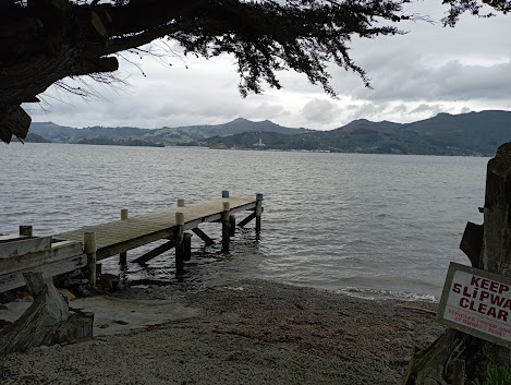
The road today, took me around the edge of Brockville and the top of Frasers Gully which is a recreational reserve that includes walking tracks through native bush and playing fields. 


I stopped to have a look at the water from the Mount Grand water treatment plant.  This is where Dunedin's drinking water is pumped to from Deep Stream.  Stopping here also gave me the opportunity to see Mt Cargill with the reservoir in front. 

 
The next part of the street involved walking along this lovely tree tunnel.  The photo doesn't show how dark it really is.  The trees are huge and form a lovely tunnel. 

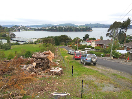
Once I had walked through the tree tunnel, I was walking down the hill to Kaikorai Valley  From here, the views started to open up with Saddle Hill and the southern suburbs in full view. 

Parts of the road that I walked down were steep and mostly I was walking past farmland.  There were a few cars on this part of the road and most slowed when they saw me walking. 

The further down the hill I walked, the view changed and I was able to see where I had been walking yesterday.  Yesterday I walked the streets that took me past the houses near the middle of this picture, along the top of the hill and down past the houses on the right .

 
Before I knew it, I was at the bottom of the hill and Kaikorai Valley was spreading out with the large buildings of the industrial area dominating this part of the valley.


I spent some time at the tree tunnel to marvel at the size of the trees.  They are huge and their trunks are massive. 

One thing I noticed on my walk of the streets was a lot of rock walls.  Most houses and a lot of paddocks had rock walls.  These walls are usually built using the stones that are removed when building the foundations for houses or by farmers clearing their paddocks. Going by the number of rock walls and how substantial most of them are, I am thinking that the land must have been very rocky.
 
This is another example of the size of the rock walls.  A lot of work has gone into making these rock walls and as you can imagine, there must be a lot of rocks. 
 
 I saw this friendly alpaca on my walk today.  It was very curious and watched me walk past. 
The map today shows the streets that I have walked in red.  The streets that I walked today run from the top left, across to the middle before skirting around Brockville and down past Mount Grand, all the way to Kaikorai Valley at the middle bottom. 
Distance walked:  9.8 km         Walking time  1 hr 45 mins    

Total distance: 1057.9  km          Total walking  197 hr 49 mins 

Monday, December 13, 2021

Day 123 Harwood

Today was my longest day of walking as I walked from Company Bay to Harwood, then walked the streets in Harwood.  I walked 14 streets today.

1666. King George Street
1667. Camp Street
1668. Portobello Road
1669. Tily Street
1670. Hanson Street
1671. Weir Road
1672. Harrington Point Road
1673. Harwood Street
1674. Carnock Road
1675. Stepney Avenue
1676. Kokomuka Avenue
1677. Michael Avenue
1678. Ide Street
1679. Tidewater Drive

I started my walk along a wet cycle/walkway at the edge of the harbour.  The weather was overcast with no rain and I knew I had a long way to go today.  I walked around the shared cycle/walkway that runs along the side of Portobello Road and unlike last time when I walked part of the cycle/walkway, I saw only a handful of cyclists and very few walkers/runners.  Today my aim was to walk the rest of the cycle/walkway.

It has taken a number of years for the harbour cycle/walkway to be built and is a real asset to the city.  There has been a lot of work gone into the cycle/walkway with some lovely bridges around some parts of the route.

 
Along the way there are seats placed with great views looking down the harbour towards the city.  A lot of effort has gone into making this shared cycle/walkway appealing for both walkers and cyclists.

There was the odd side street that I needed to walk up and from these streets, I was able to gain a bit of height and look across the harbour towards Mt. Cargill.

But mostly I walked along the side of the harbour along the shared cycle/walkway beside Portobello Road.  I was able to join some of the suburbs up that I had been in walking over the last few days together.

Commonly referred to as Pineapple Rock, this rock with a macrocarpaea tree on top and looks like a pineapple.  The walkway goes around the outside of the rock.  I had been lucky with my walk today as the weather kept improving, the further down the harbour I walked.

With the improving weather, came improving views.  I was able to look across the harbour to Port Chalmers and Mt. Cargill behind it.  Mt Cargill is the hill on the far left. 

Walking beside the harbour was very pleasant as the weather was calm and with very few cyclists, I could wander along at my own pace without having to continuously look around for cyclists.  There was also not a lot of traffic.

 
And then I reached Portobello where I had been walking yesterday. From Portobello, I continued walking around the harbour to Harwood. 

Once past Portobello, the cycle/walkway ended and I continued walking along on the edge of Harrington Point Road.  The edge of this road is wide and there is plenty of room to walk safely.  The views down habour are stunning. 

 
Eventually I walked all the way to Harwood.  There are only a few streets in Harwood with a lot of them having houses on side and the harbour on the other.

An enterprising local has created a seat using the pole.  The seat is a nice place to have great views of the harbour.  On a calm day like today, it is a magical place to sit.
Not all houses in Harwood have harbour views, some look out over rural farmland.  There are a lot of houses with horses in paddocks close by in Harwood. 
But mostly the views in Harwood are of the harbour and Mt Cargill.  This was a good opportunity to see Mt. Cargill from a distance as tomorrow is my final walk and I will be walking the streets as close to Mt. Cargill as I can get.  
I saw this 'mile peg' on the shared cycle/walkway.  This is the last of the old mile pegs remaining on the Portobello Road.  Originally there was a post every mile along the road from Portobello to Vauxhall and each post had the number of miles to Vauxhall engraved on it.  This is the only 'mile peg' left and marks 7 miles to Vauxhall.
If you are wanting to buy a Merry-go-round then I know of where one is on the side of the road.  This Merry-go-round is for sale. Somehow I don't think there is a big market for merry-go-rounds.
 I have seen some unusual signs during my challenge to walk all of the streets.  While I have seen the 'watch out for children' sign, I have not seen one with a cat as well.  
I walked past a number of nicely painted bus shelters.  These bus shelters have been painted by artist John Noakes who lived in Broad Bay.  John Noakes spent  years painting murals on bus shelters around the city.


There were a couple of interesting letterboxes today.  One is shaped like a telephone box and the other is a metal man.  Both are quite large and would hold a lot of mail.

Distance walked:  17.7 km         Walking time  3 hr 06 mins    

Total distance: 1024.3  km          Total walking  191 hr 19 mins 

Friday, November 12, 2021

Day 112 Sawyers Bay

My intention tonight was to walk most of Sawyers Bay and as it was such a nice night for walking, I kept walking until I had walked all of the streets in Sawyers Bay.  I walked 19 streets.

1513. Brick Hill Road
1514. Bells Road
1515. Stevenson Avenue
1516. Hall Road
1517. Springdon Avenue
1518. Delphic Street
1519. Kaira Street
1520. Fairview Terrace
1521. Tewsley Street
1522. Hugh Street
1523. Glendermid Close
1524. Mill Street
1525. Blackman Avenue
1526. Reservoir Road
1527. Constant Street
1528. Station Road
1529. Rohais Place
1530. Duke Street
1531. Freyberg Avenue

I started my walk by walking up Brick Hill Road.  This part of the street had slipped away after heavy rain in July 2018.  The road was closed for a number of months for extensive repairs. 

I enjoyed the rural views as I walked up the hill towards the houses at the top.  At one stage I watched a sheep in the paddock chase a rabbit for a short distance.

I was rewarded for my effort of walking up the hill, with some great views looking towards Port Chalmers where I will be walking next. 

These houses have some great views and I can imagine the residents would have been very happy when the large trees were cut down in front of their homes.  It has certainly opened the view up.

Sawyers Bay has hills on three sides which gives it a nice rural view.  There is a walking track that heads up the hill to the Organ Pipes and Mt Cargill. 

 Sawyers Bay is a nice mix of rural farmland and houses.  Sawyers Bay has a variety of views from farmland, harbour and hills.  It is a very pretty suburb.

I walked past this private cemetery in amongst the houses of Sawyers Bay.  The head stone is for the McDermid family.  Originally from Glasgow, Hugh McDermid and his wife settled in Sawyers Bay in 1849 and set up a sawmill.  Hugh went on to help set up the Port Chalmers School and Port Chalmers Presbyterian Church. 

I saw only one interesting letterbox during my walk today and it was extremely well done.  I really liked this tractor letterbox. 

 The map below shows Sawyers Bay and where I have walked is highlighted in red.
 
 
Distance walked:  9.1 km         Walking time  1 hr 45 mins   
 
Total distance: 932.7  km          Total walking  173 hr 58 mins 

Sunday, May 23, 2021

Day Sixty Three Kensington

For a number of reasons, it's been a few weeks since I have been able to get out walking so I was very happy today to be able to walk 9 streets. 

772. Ardmore Drive
773. Grosvenor Street
774. Phillips Street
775. Percy Street
776. Wain Street
777. Orari Street
778. Strathallan Street
779. Kensington Street
780. Bridgman Street

Being late Autumn, the sun rises later and I was rewarded with a beautiful start to my walk when I completed the streets around the Oval.  

I had last walked around part of the Oval back in early April so it was nice to be able to walk the remaining streets to complete the circuit.  The Oval was frosty with mist rising from the cold ground during my early morning walk. 

Today I was walking the semi-industrial streets on the flat of South Dunedin so there weren't many views so I was happy to walk the streets that were connected to the harbour.  This morning the harbour was calm with  Flagstaff and Mount Cargill looming in the background. 

While there were not many views on my walk today, there was still lots to see. One of the more iconic things I have walked past on my walks is Victor, the VW beetle up the pole outside the Bridgman Street Panelbeaters.  Victor has been up the pole since 1965. 

Another point of interest on my walk today was the Molars.  Located on Portsmouth Drive, the molars have been in place since 2010 and are inspired by the Dental School and are supposed to represent the teeth at the back of the (harbour) mouth. The molars are about 6 feet high and made out of Oamaru stone. 


One of the benefits of walking early in the morning when the sun rises is having the time to notice the beauty around me.  This tree on the edge of the Oval is particularly photogenic with the rising sun shining behind it. 
 
I also walked past a couple of interesting buildings.  One of the older buildings that I walked past is the Mayfair Theatre.  Originally called the King Edward Picture Theatre it was opened in 1914 and is the oldest surviving purpose built theatre in Dunedin and the third oldest in New Zealand.  Modernised in 1934 and renamed the Mayfair Theatre it was gifted to the community in 2014.  It continues to operate as a theatre for live performances to this day. 

Near the Mayfair Theatre is the Hillside Workshops which have operated from this site since 1875 and over the years, it has made steam engines, wagons and rail carriages.  Employing over 800 people in the 1920's it is now a shadow of it's former self  with most work carried out here, being locomotive and wagon maintenance.  

And finally for the buildings, I walked past this building on the corner of Hillside Road and King Edward Street.  It caught my eye because it has a lovely restored facade but it looks like part of the building is missing.

On the final street that I walked today, I walked past this interesting fence that has been made using power poles that still have their arms and insulators attached. 

Distance walked:  6.4 km      Walking time   1 hr 9 mins     
 
Total distance: 504.1 km       Total walking  94 hr 15 mins

Otago Harbour Cycleway 30 October 2023

With my sister in town, it seemed a shame to waste a calm, sunny day so the two of us hopped on a bike each to enjoy the recently opened 32k...