Showing posts with label harbour. Show all posts

Thursday, November 23, 2023

Otago Harbour Cycleway 30 October 2023

With my sister in town, it seemed a shame to waste a calm, sunny day so the two of us hopped on a bike each to enjoy the recently opened 32km Te Aka Ōtākou/Otago Harbour shared cycle/walkway.  We started at the Otago Yacht Club and after checking the ferry times, we headed in an anti-clockwise direction.  We followed Magnet Street past the yacht club and across the lovely Water of Leith cycle bridge.  From here we followed the cycle trail behind the logging yards and out onto Fryatt Street.  This part of the track took us through the industrial part of the city before rejoining the cycle trail near the wharf and past the Molars

The day was warm and the harbour so calm it was almost like a mirror.  We took our time, enjoying the weather and sights as we cycled along between the road and harbour.  We saw only a handful of other cyclists and the occasional walker.  It really was a magical day to be on the bike.
 
Not wanting to rush the journey we enjoyed the ride beside the harbour, watching out for birds and the odd boat shed.  The cycle trail winds in and out of all the coves and making  for an interesting ride.  There are seats dotted along the cycle way and we took the opportunity to stop for a morning tea break at one of these seats.  As the tide was going out, we were able to watch birds walking and fishing in the shallows while chatting.  It was a wonderful place to sit and watch the world go by.  

Knowing we had a ferry to catch, we carried on along the cycleway towards Portobello.  We started to notice a slight head wind and were happy that we had enjoyed most of our ride during the calm weather.  Once at Portobello we stopped at a local cafe for lunch.  There was very little room to park our bikes as the cafe is very popular with cyclists and we managed to find a seat outside in the sun.  Once replenished with lunch, we rode our bikes to the ferry dock where we met up with a number of other cyclists waiting for the ferry to take us across the short distance to Port Chalmers.  The ferry arrived and we marveled at the skill the young lady operating the ferry displayed with getting all the bikes onto to ferry, especially all the heavy e-bikes. Our lighter pedal powered bikes were put onto a special frame on the back of the boat.
The ferry ride was only 5 minutes and we were treated to a commentary of the history of the harbour along with other interesting places we passed.  Once we reached Port Chalmers, our bikes were unloaded and off we went again.  The section from Port Chalmers to the yacht club follows the train line and cuts across all the coves so we had a fast, straight run for 30 minutes from Port Chalmers to the car, made even faster and more enjoyable with the slight tail wind.   We both thoroughly enjoyed our cycle ride and would highly recommend the loop circuit - on a windless day that is. 


Saturday, August 19, 2023

#79 of 100 trips for 100 years - All Day on the Peninsula 13 August 2023


Seven people turned up on a sunny winter's morning for a trip that was tipped to be one of the longer winter walks that we'd had for a while.  Starting at Macandrew Bay, the walk around to Broad Bay was a very pleasant, easy hour around the flat cycle/walk way that skirts the edge of the Otago Harbour.  The sun reflecting off the calm harbour waters made for a picturesque walk which passed very quickly.   
We were in for a rude awakening once we reached Broad Bay because this is where the up hill started and that was to be the theme for the rest of the day,ie: if we weren't going up, we were going down, . We headed up Camp Road towards Larnach Castle which is a steep 200m climb from sea level, starting on a gravel road and ending on a narrow, grassy trail.  The higher we climbed the more the views opened out behind us and we were rewarded with a stunning vista looking across to Port Chalmers with Quarantine and Goat Island in the middle of the harbour.
While the temperature was cool, the climb up the hill had warmed us and most had stripped off our jersey before we had reached halfway.  Once we had climbed most of Camp Road we crossed into William Larnach's farm which he had purchased in the 1870's.  In 2008 the Dunedin City Council bought the land and the Hereweka Harbour Cone Trust have developed a series of walking tracks through the land to allow public access to heritage sites on the property.  We followed one of these tracks which took us past an historic cow byre which was built in 1880's and is the only remaining farm building left on Larnachs farm. 
We still had some height to gain to reach Highcliff Road but as often happens, there is always a down when going up and that is exactly what happened for us.  We dropped almost 100m down through the, at times, boggy paddocks to cross the gully and then climb back out up to Highcliff Road. Despite loosing so much height, we were still reasonably fresh and it didn't take long to regain the height and reach Highcliff Road in good spirits.
The next part of our journey took us around Highcliff Road, dodging traffic for a couple of kilometres, turning off to have lunch at the historic lime kilns.  It was here that the jersey's we'd taken off earlier were quickly put back on as we cooled down.  It was good to refuel with lunch but knowing we still had a long way to go, we packed and headed down the road, turning off onto Ridge Road and continuing down to Sandfly Bay

While Sandfly Bay is a very popular beach for watching sea lions, the track from Ridge Road is not often used and we had the track to ourselves.  After crossing from the gravel road into the paddock, we followed the fence line for around a kilometre, doding the muddy, boggy bits, until we reached the reserve and beach.  Reaching the beach was a bit of a milestone as we had started at sea level and walked from one coast of the peninsula to the other - we were now half way.
Despite there being a few sea lions on the beach, we continued on our way, skirting around the sand dunes before climbing 100m to the car park and continuing along the road, turning onto Braidwood Road. By now the feet and legs were starting to get a little tired, most likely from all the road walking but there was no choice but to continue and the beautiful coastal scenery surrounding us kept us upbeat as we began the descent back to sea level at Boulder Beach.
No one wanted to take the 15 minute detour to the beach so we sheltered under a large tree for an afternoon snack and drink break, filling up on sugar in an effort to revive the energy levels for the final 300m climb up the Paradise track, back to Highcliff Road.  The Paradise track is an unremarkable grassy climb for the first 100m before turning into a muddy, head high, flax tunnel for the next 100m.  The gradient eases off for the final 100m but it's still muddy and slippery with attention being needed on foot placement to keep upright.
It was a relief to reach Highcliff Road because there was no more climbing ahead of us - it was downhill all the way back to the car.  We wandered along the edge of Highcliff Road till we reached the Greenacres track.  I had never been down this track before and it was a bit of a surprise to see the steepness of it.  Thankfully, for us, we were headed downhill and it was reasonably dry underfoot.  Finding a swing on the steepest part of the track was a highlight and of course it had to be tested. 
By now, everyone was focused on reaching the end and we walked in ones and twos, bouyed by our achievement, happy when we finally reached the cars.   The trip had been billed as 'all day on the peninsula' and it was with having walked 23.5km from one coast on the peninsula to the other coast and back to the first coast again, with over 900m of elevation gained and lost.

Friday, March 24, 2023

#40 of 100 trips for 100 years - Harbour Cone 19 March 2023


It couldn't have been a nicer day to climb Hereweka/Harbour Cone with blue skies and a calm, mirror like harbour we started our walk at sea level, parking by the harbour at Broad Bay and following Camp Road, firstly as a steep sealed road then onto a steeper gravel road before finally onto a narrow track with long grass.  The steady climb gave us outstanding views of the harbour including Quarantine and Goat Island nestled in the middle of the harbour. 
 
As we climbed higher, we passed into more rural land with paddocks of curious horses and timid sheep on either side before emerging on Camp Road 200m higher than when we had started.  There are a couple of handily placed seats on the way up the hill giving the opportunity to sit and take in the views while catching your breath. 
Once onto the upper section of Camp Road we followed the gravel road for a short distance before going through a gate and into the paddocks that were once part of  William Larnoch's farm which he purchased in the 1870's.  In 2008 the Dunedin City Council bought the land and the Hereweka Harbour Cone Trust have developed a series of walking tracks through the land to allow public access to heritage sites on the property.  We entered the paddocks through a gate near one of these historic sites which is the cow byre which was built in 1880's and is the only remaining farm building left on Larnachs farm (as seen in the photo below)
After dropping 100m down through the paddock and scaring the sheep to the other end, we climbed over a style and crossed Highcliff Road before approaching Hereweka/Harbour Cone which at 315m is the second highest point on the peninsula, with Mt Charles trip #35 being higher.  The walk up Hereweka/Harbour Cone is straightforward with a constant gradient to the top taking around 30 minutes after crossing the road. 
The top of Hereweka/Harbour Cone has columnar basalt rocks scattered amongst the grass, making the last 5 minutes of climbing a scramble to reach the trig at the top.  From the top we were rewarded with fantastic 360 degree views in all directions. 
The wonderful views, warm temperatures and no wind made the top of Hereweka/Harbour Cone an ideal place for lunch with most of us finding it difficult to decide which direction we wanted to sit for the views.  In the end, there were a number of us that would get up every few minutes and turn slightly to get a different view.  The views are truly spectacular from Hereweka/Harbour Cone.
Being such a prominent peak that is open to the public on the Peninsula, Hereweka/Harbour Cone is a popular destination and we met a number of families making the climb to the top.  Of course the top is also the perfect place for a team photo and we had a hard time deciding which direction to take the photo.
Eventually it was time to head down and we took a slight detour, taking a different route down, following a trapping line down through the scrub before scouting around the side and back down the Highcliff Road and then down the Bacon Street track onto Bacon Street which lead us back to the harbour.  The round trip of 8.4km taking us four and a half hours with a lot of that time spent looking at the great views.

Wednesday, December 29, 2021

Day 126 Upper Junction to St Leonards

 If you have been following my blog, you will know that I have completed my challenge to walk every street in Dunedin  - and you may be wondering why I am still walking streets.  There are still a few streets that I didn't walk because they didn't fit my criteria.   You may remember that at the start of my challenge to walk every street in Dunedin, I came up with some 'rules' which included 

  1. Walking on one side of the footpath is enough to say that I have walked the street
  2. Walking on sealed roads only
  3. Private streets/right of ways are not included
  4. Not walking on roads that have high speed limits and no footpath 

There are a few streets remaining that connect some of the areas I have walked and all of these streets do not have footpaths and most are on roads with higher speed limits.  Looking at the map of the streets that I have walked, there are some obvious 'gaps' and I feel these 'gaps' need to be filled.  Today I decided to walk early and fill one those 'gaps'.

Today I walked from Upper Junction to St Leonards which is mostly rural.  I added another three streets to the number of streets that I have walked. 

1700. Strawberry Lane
1701. Upper Junction Road
1702. Blanket Bay Road

I started walking from the corner at Upper Junction and chose to walk early in the morning as there is less traffic and these roads are not busy roads

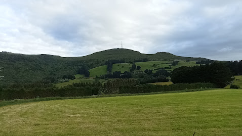
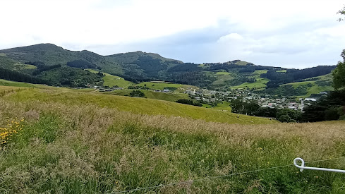
I started walking the shadow of Mt Cargill and walked along roads that wound their way through rural farmland to the edge of the harbour. 

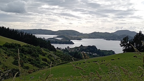
As I walked around the hill, I was rewarded with awesome views of the harbour with Roseneath in the foreground and Port Chalmers on the land jutting out into the harbour.  Quarantine Island and the hills of the peninsula are behind. 

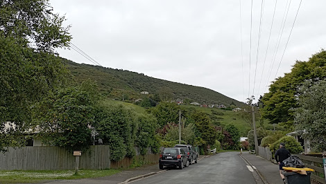
The roads I walked today are narrow, windy and have no footpath.  There were a few cars go past, however they mostly slowed down and gave me room.  At no time did I feel in danger, despite the narrowness of the road.

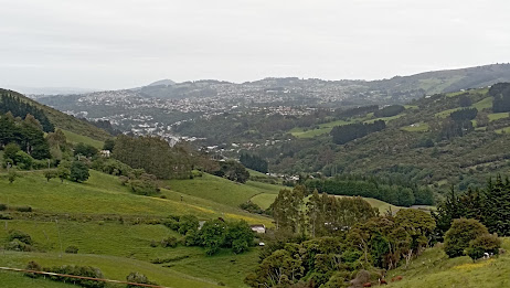
I really enjoyed my walk this morning as the views from Upper Junction Road are spectacular all the way down the hill.  While I have driven this road a number of times, it is only while walking it, that I was able to really appreciate how great the views are. 

I enjoyed looking out over parts of the city that I have walked.  This is Sawyers Bay and I remember walking those streets a couple of months ago.

I walked past a number of friendly farm animals.  While these sheep looked like they needed to be sheared, they also had a great view of the harbour. 

Eventually I walked all the way down the hill and was on the edge of the harbour.  Here I swapped the bird song for traffic noice but I was also  rewarded with great views.

I had to walk a short part of the highway to Port Chalmers.  Luckily it was still early morning so not much traffic as this was the most dangerous part to walk.

Then I turned back onto the rural roads and enjoyed the next part of my walk.  This road used to be the main road to Port Chalmers, built in the 1860's before the faster and less windy highway was built in 1965.

This road is narrow and windy and it is easy to see why the newer Port Chalmers highway was built.  I saw no traffic on this road while I was walking it today.

 
The final part of my walk was beside the newer highway which has a train line running beside it and I was lucky enough to see a train heading to Port Chalmers.

 
As in other parts of the city, on rural roads, I walked past a number of these pest traps.  These traps are put out by the Halo project to trap stoats, ferrets and rats in an attempt to give our native birds a chance to breed.  The traps are regularly checked by volunteers and all their hard work is paying off as I was serenaded with a lot of bird song during my walk this morning.

 I walked past this once massive tree that has been cut down but as nature shows how resilient it is, the tree has started to regrow.  The photo doesn't show the true size of the stump, but I can assure you that it is massive!
 
I walked past another interesting piece of nature with this overgrown patch of hydrangea bushes.  The flowers are beautiful and show how nature can shine, even when neglected. 

I didn't walk past many letterboxes today, however there was one that I really liked and it is the letterbox for Bellbird Heights - the letterbox is very appropriately in the shape of a bird house.

 
And finally this map shows the streets that I have walked in red.  Today's streets start at Upper Junction and go diagonally down the hill to Sawyers Bay and then around the edge of the harbour to St Leonards at the bottom.


Distance walked:  4.9 km         Walking time  1 hr 14 mins    

Total distance: 1042.2  km          Total walking  194 hr 58 mins 

Tuesday, December 14, 2021

Day 124 Normanby

Today I completed the last few streets in my challenge to walk every street in Dunedin. I walked 8 streets today.

1680. North Road
1681. Ribbonwood Close
1682. Cleghorn Street
1683. Corsall Street
1684. Clava Street
1685. Nisbet Street
1686. Norwood Street
1687. Potters Road
1688. Cotter Road

While walking the streets, yesterday I looked across the harbour to see Mt. Cargill.  Today I walked the streets that would take me closest to Mt. Cargill.  I grew up with this view of Mt. Cargill. 

My walk today took me up the hill and I was able to look down to the streets at the bottom of the hill.  My plan for today's streets is taking me on a large loop and I will be finishing my walk on the street at the bottom of this hill.


As I walked further up the hill, Mt. Cargill (hill on the left with the transmitter) got closer and I was able to see how much further up I had to walk.  The group of trees on the skyline in the middle of the picture is as far up the hill that I needed to walk.
Today I was walking on the northern edge of the city and could look back over farmland.  At the bottom of the field is the Forrester Park sports fields that include a dog park and BMX track.  This used to be an old city dump and was covered over to create recreational facilities for the city many years ago.

As I walked around the side of the hill, I could look back over the northern part of the city.  From here, I was able to see the town belt easily.  The town belt is the 'belt' of trees through the middle of the city.  The town belt was planned in Scotland around 1848 and is one of only three town belts in the world. It is an example of the native bush that would have covered the hills before the settlers arrived and the city was built.

I walked a number of short side streets today and one of those side streets took me around the hill to a view of the harbour and the hills of the peninsula.  I was able to look down to where I was walking yesterday, around the road at the base of the hills.  This view was a nice surprise. 

Then I was back to the main road and onto the top of the hill.  This is as close to Mt. Cargill as I got and from here it is easy to see why the Maori legend tells of  Kapukataumahaka /Mt. Cargill being a warrior lying down.  Mt. Cargill has the transmitter on the top and is the body of the warrior while Buttars Peak to the right is the head with the legs of the warrior to the right of Mt. Cargill.


As I reached the top of the hill, I had one final view of the city before I walked down the hill to the street at the bottom (in the middle of this picture).  I had started walking from this street and walked up the hill around the left before walking down on the right back to where I started walking.

The road down the hill was a lot steeper and narrower than the one that I had walked up.  This road is mainly used by the local farmer but it made a nice loop to walk and had houses near the bottom.

The final view I had was at the bottom of the hill, looking back up to where I had walked earlier.  The houses in the middle of the hill are on streets that I had been on as I walked up the hill.

 
One place of interest that I walked past today is the Upper Junction School war memorial. The large macrocarpa trees were part of the school grounds and there has been a lot of work done recently to tidy the once overgrown site.
There is no school here as it was burnt down in 1945 but the war memorial site is still maintained   The memorial is for seventeen former pupils of the school who were killed during the first world war.

This memorial site is of particular interest to me as one of the memorials is for my fathers uncle who died aged 20 during the first world war.  A beech tree has recently been planted beside each memorial. 

 
At the view of the harbour, I saw how some enterprising locals have made their own seats and bar leaner.  I could see how this would be a great spot on a warm summer evening with a glass or two to drink. 

There were only two interesting letterboxs that I walked past today.  I really liked that it is shaped like the house that it belongs to and I thought the microwave was a good letterbox was a good use for something that was no longer needed. 


Distance walked:  8.4 km         Walking time  1 hr 40 mins    

Total distance: 1032.7  km          Total walking  189 hr 53 mins 

Otago Harbour Cycleway 30 October 2023

With my sister in town, it seemed a shame to waste a calm, sunny day so the two of us hopped on a bike each to enjoy the recently opened 32k...