Monday, November 28, 2022

#12 of 100 trips for 100 years - Tomahawk to Highcliff 26 November 2022

This day trip is one that was first completed by the Otago Tramping Club on 6 October 1923. 99 years later, a group of 8 OTMC members met to recreate this early OTC trip, which is predominately a road walking trip over what would have been gravel roads and is now sealed. Starting at the old tram terminus (junction of Silverton, Highcliff and Tomahawk Road), we followed Tomahawk Road around to the Andersons Bay Cemetery where we took a detour through the cemetery before rejoining Tomahawk Road to cross the bridge and then take another detour onto Tomahawk Beach.
With the tide out there was a large strip of exposed sand and very few people which made for very pleasant walking. All too soon the beach came to an end and we headed up through the soft sand dunes to the Ocean Grove playground, where we again rejoined Tomahawk Road and then onto Centre Road. Now the fun part began as we started the steady climb up Centre Road. There was much to see on Centre Road, from admiring the old stone cottage, marvelling at the windswept trees, checking out the sections for sale, patting the horses and looking behind at the vast ocean. 
It's a climb of about 200m over nearly 3km and with very little traffic we were able to walk and chat in pairs and in small groups which made the climb pass very quickly. Once we reached the top of Centre Road and onto Highcliff Road we were rewarded with our first views of the Otago Harbour. We spent a few minutes looking across the harbour to Signal Hill and the Burns Reserve which is where we'd been nearly a month ago for trip #4/100 trips. 
A short walk along Highcliff Road and we took another short detour up the hill to the Soldiers Monument with panoramic views of the harbour, Mt Cargill, Dunedin City and Saddle Hill. It is not often that there is no/very little wind at the monument and we made the most of this rare opportunity by having a break and refueling with snacks and a drink. From the Soldiers Monument it is all down hill, following Highcliff Road back to the junction with Silverton Street and Tomahawk Road, where we had started 11 km and 3 hours earlier. 
Despite being a road walking trip, it ticked all the boxes 
  • great social trip by being able to walk and talk with others more easily on a sealed road 
  • wonderful views of our harbour that are often only glimpsed when traveling by car 
  • exercise with a 200+m climb and time to notice things we'd not seen before 


Wednesday, November 16, 2022

#9 of 100 trips for 100 years - Pipeline Track - Rustlers Ridge - Swampy Lagoons - Leith Saddle Walkway 13 November 2022

The weather forecast was for afternoon rain so it was pleasing when 10 of us arrived at the Leith Saddle Walkway carpark in sunshine and warm temperatures. Leaving the carpark we followed the Waitati Valley Road for about 500m to the Pipeline Track and from here it was a nice easy stroll for about half an hour following the pipeline which traverses around the same contour line to the Rustlers Ridge track. The pipeline once supplied water to the Northern suburbs of Dunedin. Once at Rustlers Ridge the track makes a sharp turn up the hill with a steady climb on a well-defined and sometimes steep-sided ridge through the native bush. We stopped for a brief rest and drink at the edge of the bush where we had uninterrupted views of the Silver Peaks including The Gap, Pulpit Rock and Rocky Ridge. This is the area that we had been walking two weeks ago on trip #5 of 100 trips for 100 years.
After our rest, we continued up Rustlers Ridge and onto Swampy Summit where we noticed the clouds were starting to obscure the sun and the temperatures were cooling. Not to be deterred we left the track to wander over the peat bog that has formed a wetlands in a hollow on Swampy Summit. It is an interesting area covered in subalpine vegetation, bogs and tarns and is not often visited as there are no tracks through this fragile wetlands.
Heading in an Easterly direction it didn't take long before we came across the first of the tarns. It's hard to judge the depth of the tarns as the water appears black. We found a number of black tarns varying in size. Thankfully the weather had been good over the past few weeks and the peat bog surrounding the tarns was not overly wet which made for pleasant walking.
The peat bog is very different to the surrounding vegetation and is a fascinating place to explore. The area of peat bog surrounding the black tarns is reported to have been where Moa gizzard stones were found in the late 1800/early 1900's. Sadly we didn't find any gizzard stones but this might have had more to do with the fact that none of us knew what a gizzard stone looked like. The colours of the vegetation in the peat bog surrounding the black tarns is quite stunning ranging from bright green through to yellow and orange
We could see the clouds were getting darker and the wind was picking up so we didn't linger at the black tarns as long as we would have liked and we made our way through the scrub towards the telecomunication tower. This proved to be tricker than first thought as the scrub was much denser than where we had entered the bog and some of us emerged dripping blood after doing battle with the scrub. Sheltering behind the telecomunication building to eat lunch and clean up some of the battle wounds, we were well aware that the weather was changing rapidly. We were chased down the Leith Saddle Walkway by a cold wind and the first few drops of rain. Traditionally the views from the Leith Saddle Walkway are worth taking your time over but today our main intention was to beat the rain so we powered down the hill, stopping only briefly at the lookout and reaching the road and carpark about 4 hours and 11km after leaving. We couldn't have timed it better as the rain arrived just as we were driving out of the carpark.

Tuesday, November 15, 2022

#8 of 100 trips for 100 years - Craiglowan Falls & McQuilkans Creek 12 November 2022

The steepest part of the trip was the first 15 minutes as we left the Bull Ring and headed up the Fire Break track. In the winter this familiar track can be muddy and slippery, however at this time of year it is hard and dry which makes for easy walking. Eight of us regrouped at the turn off to the Big Rock track and from here the track looks to have been recently cut as it winds it's way through the lush, native bush. Apart from the odd rock and pig rooting, the track is easy to follow and heads quite steeply down the hill to Big Rock which is exactly as the name suggests - a BIG rock. Back in the pre-1960's, Big Rock was popular for rock climbing with the OTMC. It was at Big Rock that we had some of the best views of the trip, looking over the Silverstream area, towards The Chalkies and Silver Peaks. Today Big Rock is surrounded by bush making it hard to guage the size of the rock and there certainly is no rock climbing here anymore.
After a short stop at Big Rock we found our way down, around the side of Big Rock before discovering that this was the end of the wide, recently cut track and from here we were following a faint trail down hill. Coming across the odd mud puddle was reassuring as it confirmed we were following the trail until about halfway down the hill we must have taken a wrong turning because there was no more trail and we were literally bush bashing our way down the hill, clambering over rocks, ducking under branches, getting tangled in vines and running into the odd patch of bush lawyer.
After nearly an hour of this enjoyment we emerged onto the gravel of the Flagstaff-Whare Flat Road, slightly scratched but still in good spirits. After a brief stop for a drink and snack we had an easy walk down the road to the forresty road, Sanatorium Road which is the site of the first sanatorium in New Zealand. Established in 1899 it accommodated up to 10 patients at a time suffering from consumption and other tubercular diseases. There is nothing to see here now so we continued along Sanatorium Road until the turnoff on the right down the hill to McQuilkans Creek. Again it's a steep descent but with plenty of trees to hold onto it didn't take long for us to reach the creek and our objective of finding the Craiglowan Falls. The rocks were slippery as we crossed the creek a couple of times but eventually we rounded the corner and were rewarded with a view of the not often seen Craiglowan Falls.
We enjoyed a rest and photo opportunity here before slipping and sliding our way along the creek, climbing around large rocks and generally trying to avoid falling in as the rocks were very slippery. There was the occassional wire across the creek to help keep us on our feet but over all I was glad of my walking pole to help keep me upright.
After about half an hour of this fun, the track turned off onto an easy four wheel drive track that resembled a grassy meadow in parts. We passed some beehives and arrived at a gate. It was a bit disconcerting to see the 'No Entry' sign prohibiting access to where we had just walked down. Oh well, there had been no sign at the other end of the track so we ignored the sign and climbed over the sty onto the Whare Flat Road.
Now the third part of our walk began as we walked along the Tunnels Track which followed the old Silverstream water race. At one time the water race supplied water to the growing town of Dunedin. It was quite a fast walk along the track for a couple of kilometres as the track follows the contour of hill before heading down hill to Silverstream. Just before the downhill section, the team called it time for a lunch stop and we enjoyed a half hour sitting and chatting while eating lunch. Spurred on by promises, from our leader Ash, that the car was only 15 minutes away we didn't linger too long over lunch and were heading down hill at a good pace. After crossing the Silversteam, we reached the cars in 12 minutes from our lunch stop. All in all a fun 8.5km walk in just over 4 hours.

Sunday, November 13, 2022

#6 of 100 trips for 100 years - Day Trips from Omarama 5-6 November 2022

This trip has been run by the OTMC twice before (2008 & 2010) both lead by me so it seemed fitting that I lead it again. As it turned out, we couldn't stay at the Omarama campground where we had stayed the last two times as it was badly damaged by flooding in the winter so we changed to the Lake Ruataniwha Holiday Park near Twizel. As it turned out Ruataniwha was a great place to be based with lovely spacious cabins and the lake only a 5 minute walk.
It was a good start to the weekend waking to clear skies and birdsong on Saturday morning. After checking what each of the 5 different parties were doing, a group of six of us set out for Ben Ohau via Greta Track. Arriving at the Ben Ohau carpark we regrouped and walked about 5 minutes along the road to Gretas Stream where we followed an old four wheel track as it climbed through the green paddocks. It was surprising how quickly we gained height and the views of Lake Ohau started to open out.
It is important to note that the four wheel drive track branches off to the right just before reaching the fence on the shoulder of the hill. From here the track becomes more interesting as it winds it's way up, following the creek. The track is easy to follow with the occassional patches of bush to provide some shade and crossing the river a number of times. Getting wet feet with the river crossings was compulsory as the water was above the knee for all but the last crossing.
By following the creek, we were slow to gain height but this only added to the enjoyment of the trip with changing views as we rounded each corner. Behind we had glimpses of Lake Ohau and the hills sorrounding the lake while in front the higher we climbed the more the valley opened out to rolling tussock hills.
It was sad to see the wilding pines starting to make their way this far into the hills. There was a short but steep section of track just before leading to the ridge where we were rewarded with expansive views looking towards Twizel and Lake Ruataniwha with the winding blue canals snaking their way through the McKenzie Country.
From the ridge, it looked as though we had done about half of the climbing we needed to reach the summit of Ben Ohau. The walking from here was not difficult as we followed an old four wheel drive track that wound it's way along the open ridge and around the side of Ben Ohau. The track was a constant gradient and not overly steep but by now we were out in the open sun and the temperatures were rising. It was about half way along the ridge to Ben Ohau that a halt was called for a lunch stop.
Once we had refuelled with lunch the rest of the walk up Ben Ohau didn't seem to take long and we were at the saddle where we turned off the four wheel track and headed up beside an old fence to the top of Ohau. While there was a definate trail up this part it was more of a rock scramble and required some concentration over the rocky parts. This is the fourth time over the years that I have been to the top of Ben Ohau and each time it's always been a scramble up this part but today it didn't seem so bad as there is a clear trail to follow. The climb has become very popular judging by the number of people we saw on this part of the trip. Once the summit is reached, the views are spectacular in all directions.
Once at the top it was compulsory photos as well as topping up with a drink and some lollies before heading down and down it was, all 1000m to the bottom. The track we took down the hill was a zig zag down the front face of Ben Ohau and while it wasn't overly steep it was a constant pounding down the hill. It was becoming quite hot and with no shade, whatever water that was left in the waterbottle was soon gone and on we went until, eventually the bottom of the hill and the cars were reached. From the bottom, it was good to look back up at Ben Ohau. A great round 18.5km round trip with just over 1000m of climbing.

Tuesday, November 8, 2022

#5 of 100 trips for 100 years - Silver Peaks - The Three Ridges (Yellow-Rocky-Green) 30 October 2022

I was more than happy for a break to rest and refuel at the Phil Cox Hut after a fast descent from Mountain Road carpark down the Tunnels Track to the Waikouaiti River and a very quick ascent up 250m to Phil Cox Hut by the 10 enthuasitic trampers who had turned up for a day tramping in the Silver Peaks. We had taken a photo of the team at the start, all looking fresh and eager for the day's walk. I wasn't feeling so fresh or eager after an hour of fast walking to get to the Phil Cox Hut.
Once we'd all had a chance to top up the energy with a snack we headed along Yellow Ridge at a slightly slower pace. I found this part of the trip interesting as I reminised over the changes of Yellow Ridge over the past 35+ years. Yellow Ridge was once an open yellow tussocky ridge with great views all around. Today the views are still there but I'm not sure for how much longer. The ridge today has a narrow band of yellow tussock but is mostly scrub. Yellow Ridge is now becoming more green than Green Ridge.
It was another 1.5 hours before we reached the turn off to Rocky Ridge which is not obvious and required a bit of bush bashing for the first 50 or so metres until the feet found something that resembled a track. It was impossible to see my feet due to the waist/shoulder high tussock so I just trusted my feet to keep to the track which was not always the case and there were frequent times when it took some scouting around to find the track again. This is the part of tramping that I enjoy, getting off track and relying on instinct to keep me heading in the right direction.
The group stayed close together and once we found a large rocky area about half way along Rocky Ridge we stopped for lunch. Rocky Ridge has also changed a lot over the past 35+ years since the stock has been taken out of the Silver Peaks Reserve. Previously Rocky Ridge (like Yellow Ridge) was open tussock and you could walk at will down any of the adjoining ridges - not any longer, it is fast becoming overgrown with scrub. Lunch was an enjoyable rest with expansive views of the Silver Peaks and surrounding hills.
All too soon lunch was over and our journey along Rocky Ridge continued. There are a few hilly parts of Rocky Ridge that I had forgotten about and once we reached the Hermits Cave turn off the track became more obvious. We stayed on Rocky Ridge and passed the Cat's Teeth which are always an interesting part of the ridge with the track weaving it's way between the large rock tors. This part is very different to any where else on Rocky Ridge.
Once we reached the end of Rocky Ridge and were onto the main Silver Peaks track it was a quick descent to Green Hut Site for another refueling stop and the final hour's walk out to the cars. Thankfully the final hour's walk was not as fast as the first hour and we arrived back at the cars 16.5kms and 6 hours 50 minutes after starting, looking tired, scratched and happy to have completed one of the classic routes in the Silver Peaks

#4 100 trips for 100 years - 29 October 2022 Signal Hill to Ravensbourne (by Jade Pettinger)

This is my third trip of the 100 trips. Being a Saturday afternoon trip I wasn't sure how many people would be on the day walk and was pleasantly surprised to have a 23 other people join me on a short afternoon walk around the Burns Reserve in Signal Hill. The Burns Reserve borders private property and having permission to cross the private property to make a round trip was the most likely reason that so many people were keen to join the trip. A long line of people left the Signal Hill lookout and crossed the fence to follow a faint trail through the native bush of the Burns Reserve. There were a few tree roots to negotiate along with some bush lawyer and some slippery mud. We passed quite a few traps which were doing their job because there was bird song in the bush.
After the native bush we passed through a small section of pine trees then followed a fence line to a gate with a 'No trespassing - Bull in paddock' sign. This is where we crossed onto private land and were a bit cautious as the paddock with the sign had a number of cows, although there were no bulls in sight.
After passing through the gate we made our way across the paddock and over another fence that lead us up to Gerry's rock where we were rewarded with 360 degree views over the harbour, peninsula and towards Mt. Cargill.

We could have spent much longer here but the farmer had arrived to escort us through the rest of his paddocks and down the hill to the road which we followed along till we reached the Logan Park mountain bike tracks. We followed the walking track up the hill back to the Signal Hill monument. All up the trip was around 5km and took a little over 2.5 hours. 

Written by Jade Pettinger

#2 of 100 trips for 100 years - Greenstone/Caples Area 22-24 October 2022 (by Jade Pettinger)

Four of us piled into the car on Friday morning, pleased to be trading in a wet, grey Dunedin day for a sunny weekend in the mountains. After a monotonous five hours of driving we finally arrived at the end of the road and quickly scrambled to get onto the track. Knowing we had some big days ahead of us, we were eager to get going and cover some distance before evening. Setting off from the carpark at 2pm, the track begins with a climb to get through the gorge before branching off into two tracks - the Greenstone and the Caples. We took the swing bridge over the river and made our way up the Greenstone. We happily wandered along the track for a couple of hours, mostly in the bush but enjoying the short open sections. The weather was superb, not a cloud in the sky and just enough of a light breeze to keep us cool.
We eventually reached Slip Flat and began contemplating where to set up camp for the night. We consulted the map and decided to check out the nearby Slip Flat Hut to see what it was like. There was no marked track up to the hut, so after a bit of bush-bashing and a scramble up the hillside we were delighted to reach a small clearing containing a tidy 3-bunk DOC hut. We quickly set up camp with Dave and myself in our tents whilst Debbie and Antony opted to spend the night inside the hut. We enjoyed a lovely evening around the fire (thanks to Dave and the healthy amount of dry wood nearby) before turning in for the night.
We awoke on Saturday morning to clear skies and dew on the tents. It was quite chilly in the shade of the valley so we got ourselves organised and underway fairly quickly. We made use of the emergency bridge crossing Slip Flat Creek to keep our feet dry and enjoyed walking through the bush for a while. We soon came to the turnoff for Greenstone Hut so dumped the packs and went to have a look. Whilst crossing the bridge over the Greenstone River we saw a group of packrafters scrambling down the side of the gorge, getting ready to set sail. We watched them with great curiosity as one by one they slipped into the fast flowing water and made their way downstream. It was then back to the packs to carry on for a bit until morning tea time.
The condition of the track after the turnoff to the hut deteriorated as it was littered with windfall. After making our way over and around a couple of large trees, we opted to bush bash our way down the bank to the open river flats. We enjoyed a picturesque morning tea break on the shores of the Greenstone River before carrying on up the valley.
We soon rejoined the track and from here it was a few hours of walking along the open river flats. We spotted the odd cow grazing in the distance as well as Rats Nest Hut across the river. The wind had started to pick up a bit and after meandering along for a couple of hours, we found a sheltered spot to have lunch. We enjoyed lying in the sun for a while before continuing.
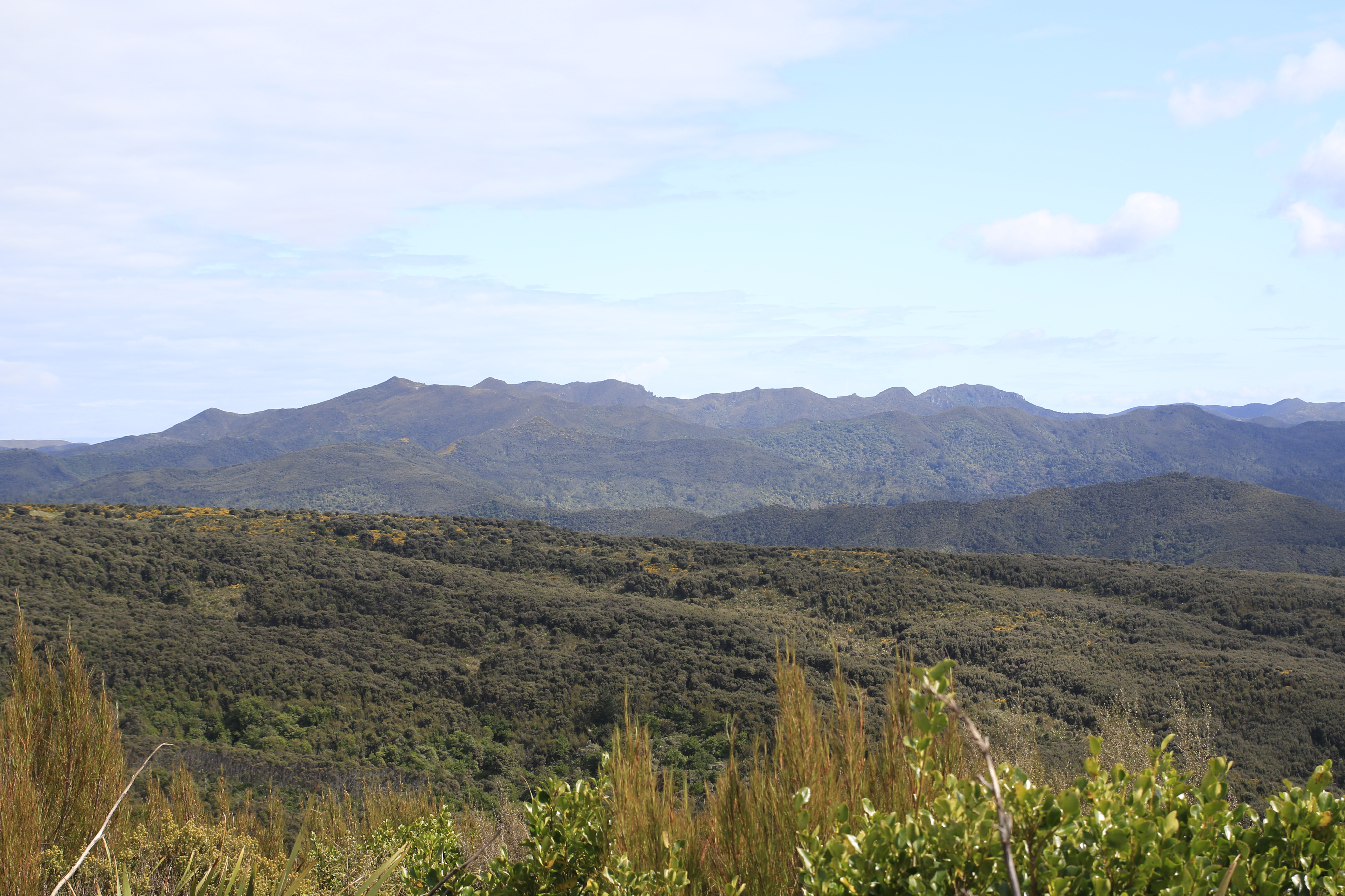
The further up the valley we got, the more we noticed the landscape around us beginning to change. As the sky was clear, we could see Mt. Christina looming ahead, as well as catching brief glimpses of Tutoko and Madeline. We enjoyed the ever-changing scenery for the afternoon - from wide open river flats to picking our way across a large rockslide to sections in the bush. There were some boggy bits that required extra care otherwise it was largely an uneventful afternoon.
Around 5pm we began looking for a suitable campsite for the night - it turns out this was easier said than done. We wanted somewhere flat, sheltered out of the wind, a nearby side creek for drinking water and away from the cows. Another hour of walking later and just as we were contemplating heading to McKeller Hut as it was only a few km away, we finally found somewhere that ticked all the boxes. It was now getting close to 7pm so we got ourselves set up and turned in for the night.
After one of the comfiest nights I’ve spent in a tent (thanks to the lovely soft ground) we awoke to find a couple of cows had decided our campsite was going to be their grazing patch for the morning. They didn’t seem bothered by us and before long we were back on the track. We enjoyed a short break at McKeller Hut before winding our way up alongside Lake McKeller. We found a few tracks that enabled us to get down to the lake shore to have a look - absolutely beautiful!
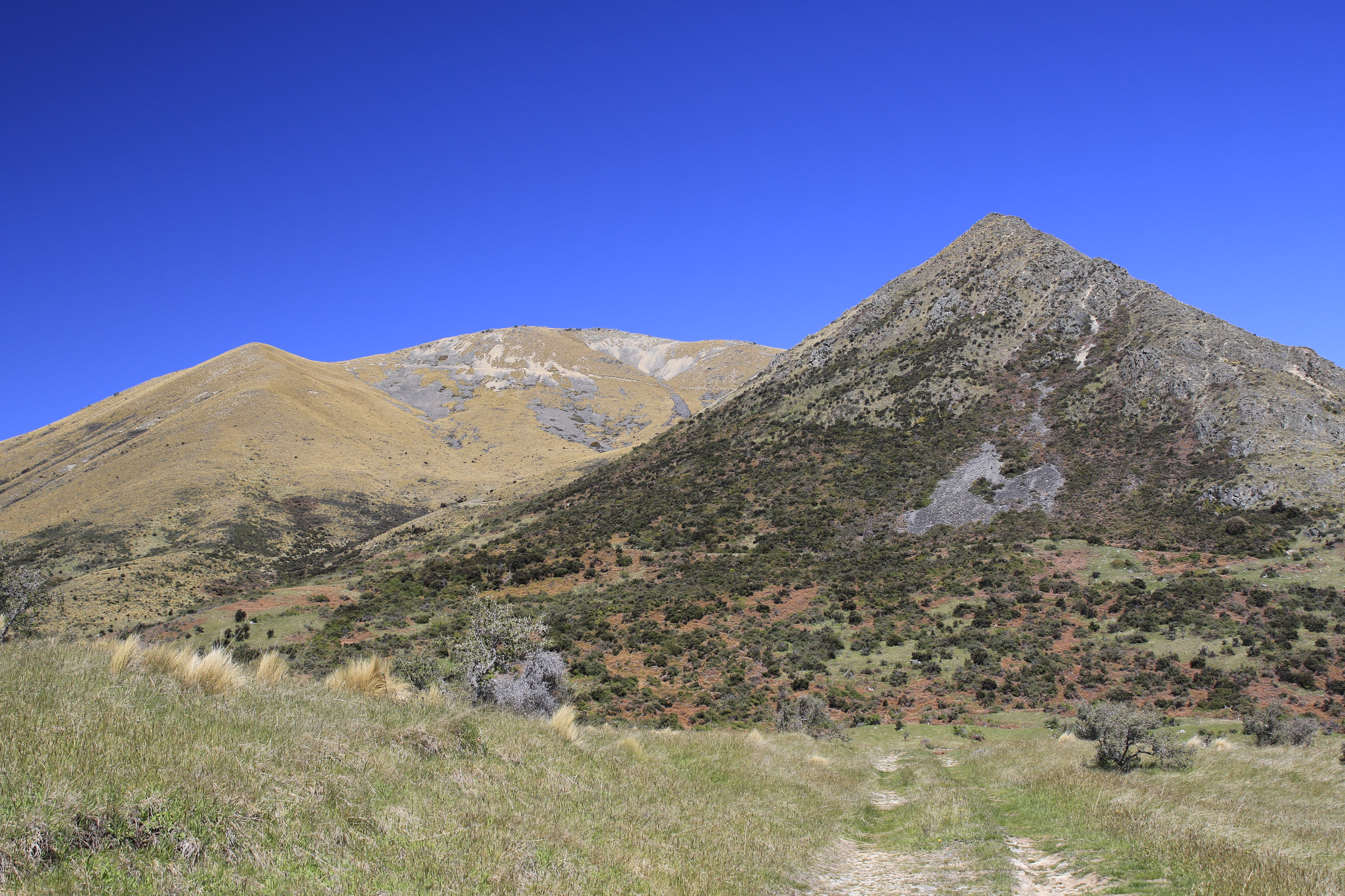
A quick morning tea stop at the turnoff to McKeller Saddle / Lake Howden and before long we were beginning our ascent up to McKeller Saddle. The track was nicely graded and gently made its way up the hill, as opposed to the steep track Antony and Debbie remembered from their youth. We enjoyed plenty of stops to marvel at how high we had climbed from the lake. We made good time and reached the top in just over an hour. We found a sheltered spot to have lunch before enjoying the views from the saddle.
Being a beautiful blue sky day, the view in all directions was stunning. Looming ahead of us was the distinctive Mt. Christina, which Antony remembers as a boy being the first mountain that made him fall in love with tramping. As much as we wanted to spend hours on the saddle, we weren’t able to linger too long as we still had the descent down to Upper Caples Hut ahead of us. We enjoyed crossing the boardwalk, dotted with tarns that reflected the mountains perfectly.
Far too soon we were saying goodbye to the saddle and heading down towards the Caples Valley. The track down seemed to be much longer than going up the other side and we were soon over the relentless pounding on the hard gravel track. We were all tired and had sore feet after walking nearly 20km, so you can imagine how relieved we were to reach the turnoff to Kay Creek as this indicated we were close to the hut. After catching up with the other OTMC parties at Upper Caples Hut, we set about pitching our tents and getting dinner started. We were soon eaten alive by sandflies, a sharp contrast to the non-existent sandflies of the previous two nights. After cajoling a friendly tramper to take a group photo of the 20 OTMC members at the hut, we turned in for an early night as some light drizzle started to set in.
After spending the night listening to the raindrops on the tent, we were not surprised to awake to a grey, misty and wet day. We quickly packed up and were on the track by 7:30am, with most of the other OTMC parties leaving ahead of us. It was a pretty bleak walk down the Caples Valley as the rain did not let up. We enjoyed the moody landscapes as we powered along the river flats before stopping at Mid Caples Hut for a sugar boost.

From Mid Caples Hut we put our heads down and walked, it was too wet to be stopping. Excitement levels were high when we reached the junction with the Greenstone as we knew we only had another 20 minutes to go. With the car park in sight, we raced down the final stretch, excited to soon be putting dry clothes on and warming up. Thanks to Antony for organising the trip, it was fantastic to have 27 OTMC members spend the (mostly) sunny long weekend tramping in the Greenstone and Caples Valleys. A great way to start the 100 Trips for 100 Years Centenary Programme. 

Written by Jade Pettinger

Otago Harbour Cycleway 30 October 2023

With my sister in town, it seemed a shame to waste a calm, sunny day so the two of us hopped on a bike each to enjoy the recently opened 32k...