Showing posts with label Swampy Summit. Show all posts

Sunday, September 10, 2023

#89 of 100 trips for 100 years - Nicols Creek - Powerline Track - Morrisons Burn 9 September 2023


While the trip today was over part of last weekend's route, the weather was a complete contrast - from last weekend's mist with no views to stunning blue skies and spectacular views galore!  Seven of us set off from the Nicols Creek car park with the first 1.5km being a road walk up Leith Valley Road to the Morrison Burn track, which we had come down on trip #15.  After passing through the gate, the Morrison Burn track follows a maintenance road for a short distance before turning off onto a track through the native bush.  The track winds it's way uphill, over tree roots and through the odd muddy section, under gnarly fushia trees, through ferns and beneath the giant fern leaves of the punga.  After about half an hour we emerged out of the bush onto the Powerline track, which as the name suggests, follows a row of powerlines to the top. The higher we climbed, the more the views opened out behind with the vegetation changing to the flax. 
Taking our time we continued uphill climbing 600m from the car park to the top of Swamp Summit where we stopped for a breather and take in the views.  Deciding that it was too early in the day to head back down, we took a detour over the top of Swampy Summit.  First we followed the gravel road to the Flight Radar or UFO as it is commonly referred to.  From here we could see into the Silver Peaks, up the coast to Karitane and inland to the Rock and Pillars. The panoramic views really are spectacular from here.
Next we took the detour through the tussock to the Swampy Lagoons which we had been to on  trip #9.  There is no track to the lagoons and the ground under foot was mostly sphagnum moss so was very wet . The trick was to try and judge which bits would sink and which would bear your weight - we each had our own method with varying degrees of success.  There are a number of small lagoons and a couple of larger ones and we arrived at the larger one with mostly dry feet.  The colours in the lagoons is breathtaking with the calm, black water of the lagoon perfectly reflecting the browns, greens, yellows and oranges of the surrounding tussock. 
We each found a dry spot for lunch and enjoyed the beauty of the place while munching on our sandwiches.  After lunch, we were faced with the problem of finding the track again so we made our way through the wet, springy moss, tussock and low scrub as best we could to the track which we followed down Swampy Summit to the Moon Track.  The top part of the Moon Track passes through the tussock, beside an old fence and onto the  mountain bike track which zig zag's down the hill, winding through the large rock tors before passing into the native bush .
At bush line, we diverted off the mountain bike track, onto the walking track which takes a much more direct route down the hill.  The walking track crosses the bike track regularly so care is needed to stick to the walking track.  Despite having seen a number of mountain bikers setting off early in the day, we saw or heard no one on either the walking or biking track. The Moon Track initially drops 300m to a lovely vantage point where we stopped for a short break to take in the stunning views of the city.
Then it was down another 200m back to the cars, passing Nicols Falls where we stopped in the cool of the gorge to catch our breath.  The final push saw us back at the car 6 hours and 16.2km's after starting and no wonder we were feeling a little tired, after having climbed/descended nearly 800m. 


Wednesday, August 30, 2023

#84 of 100 trips for 100 years - Flagstaff/Swampy Summit/Swine Spur/Ben Rudds 26 August 2023


The day was very warm and felt like we had turned a corner from the colder temperatures of winter, so much so that the seven of set off from the Bull Ring up the Pineapple Track in t-shirt and shorts with a spring in our step. The 160m climb to Flagstaff is reasonably steep but taken at a steady pace only takes about half an hour. During our walk up the hill the sea fog that had covered the city had started to clear and we were greeted with the stunning panoramic view of the city with the tendrils of sea fog, retreating down the harbour. 
After a brief stop at Flagstaff, we continued along the Pineapple Track and took the detour of the Cross Track onto the Firebreak Track, heading towards Swampy Summit.  This part of the track is always a bit deceiving as it looks to follow the same gradient with only slight rise and falls but don't be fooled because there is a steady descent of 120m then a steep 180m climb to the broad flat crest of Swampy Summit. 
We stopped at the Swine Spur track and thought it would be a good place for lunch before dropping down into the valley but it was a little early for lunch so we continued on over Swampy Summit for about another kilometre to the 'UFO' which is a flight radar and looks a little like a UFO on the very top of Swampy Summit.  For this extra bit of effort to get here we were reward with stunning views looking towards Palmerston where all the hills looked like islands with the coast still shrouded in sea fog and miles of golden tussock in the foreground. 
After an ample amount of time admiring the views, we retraced our steps to the Swine Spur junction and each found a spot amongst the tussock for lunch.  We were feeling on top of the world with such beautiful views, gorgeous weather and the place to ourselves. After lunch we headed down Swine Spur which steeply descends down into the valley with often muddy sections to negotiate.  Most of this side of the hill is open tussock with a few scrubby bushes although we were too engrossed watching our footing to notice the views during our descent. 
Soon enough, we reached the manuka forest and followed the track as it continued down hill. Once we reached the Possum Busters track we turned left and followed it around for about an hour, past Porkies and McQuilkans tracks to the junction of Smithy's track.  We had been here before only about a month ago for trip #74 Having just lost 440m in height and after a final stream crossing, we were now faced with a steep 200m ascent up to Ben Rudds.  We each found our own pace on this uphill section and slowly wound our way up the hill, through the rhododendron dell, under the native bush canopy to the Ben Rudd shelter where we had been just last week for trip #81 for the tribute to the Family Tramping Group.
Thanks to a unanimous decision, we elected to have a rest at the shelter and replenished the energy levels with some snacks and a drink before the push up the final 100m height gain to reach the Firebreak track where we could stop and look back towards Swampy Summit and Swine Spur where we had been earlier in the day. 
We could see that the clouds were starting to thicken but the temperatures were still warm and we were pleased that we had made the most of the lovely spring like weather by getting out into the hills.  All that remained was for us to follow the Firebreak track back to the cars, chatting as we dropped 120m in height down the wide track.  It had been a really enjoyable day that had been a real mix of up and down with over  800m of ascent/descent and covered 16.2km in 6.5 hours. 

Wednesday, February 15, 2023

#31 of 100 trips for 100 years - OTMC Silver Peaks Half Marathon 11 February 2023

Through the 1970's-2000's the OTMC Marathon has held legendary status for those wanting to test their fitness over the 60+km course through the Silver Peaks.  Nowadays part of the original course is not so easy to access as it goes through pine plantation and at nearly 40km long the half marathon is still a considerable challenge.  It was heartening to have eight people arrive for the 6am start of the Pineapple Track for what was sure to be a long and tiring day. 

The Pineapple Track climbs a steep 480m to the top of Flagstaff starting with native bush and eventually onto the tussock tops.  Starting in the dark through the bush and coming out into the tussock gave us a chance for a short stop to take in the sunrise and the beautiful coloured sky promising a warm day ahead. 
We didn't have time to linger for too long because we still had a long way to go.  Up the hill we went enjoying the sunrise and the wonderful cloud formations as we continued on to the top of Flagstaff.  It was here that we  stopped for a breather and drink at the top by the plane table.  A fitting place to stop with the plane table highlighting features on the city skyline, and was installed in 1973 by the OTMC after it's 50th anniversary and here we were, about to celebrate the 100th anniversary. 
By now the sun was up and with the first uphill section completed we were able to relax a little and regain our breath as we started downhill to the Bull Ring.  We regrouped at the Bull Ring before tackling the 6km road walk of Whare Flat Road  to Silver Stream which saw us drop 400m in height, effectively losing all the height we had gained. 
The road walk wasn't as bad as I had feared with the time passing quickly as we all took the opportunity to chat on this downhill section.  Being still early there was very little traffic on the gravel road and we were able to stop at the ford where one of our OTMC members, Trevor Mason, drowned while completing the OTMC marathon 15 years ago.  Unlike 15 years ago when the weather was atrocious and the river was rushing over the ford, today there was no water and we were able to cross with dry feet. A complete contrast to 15 years ago. 
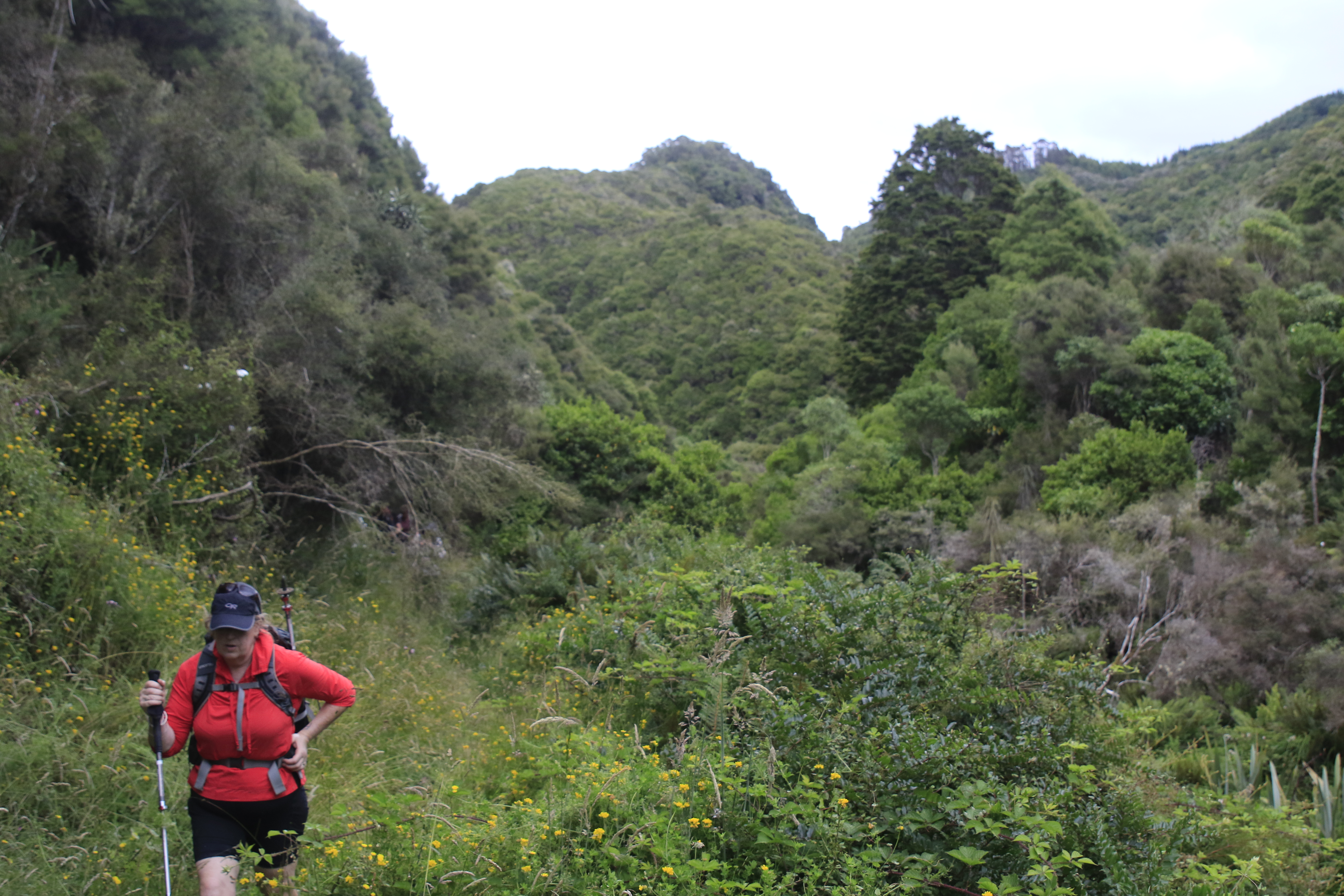
Once at the bottom of the hill we climbed over the stile and walked alongside Silver Stream through the bush to the weir.  We crossed the weir before taking the track towards the Powder Hill turn off which is where the fun really began as the climb of 480m up Powder Hill is particularly steep and gnarly until the ridge is gained and the gradient eases off slightly.  Even though the upper part of the ridge is not as steep as lower down it continues to climb and fall as the track goes over a number of false summits before reaching the junction with Long Ridge. All the height we had gained climbing up Flagstaff, then losing as we headed downhill to Silver Stream, was gained again on Powder Ridge.  Stopping for another breather in the shade of the bush at the junction of Long Ridge we contemplated that we were half way through our journey and thankfully most of the climbing was behind us. The walk along Long Ridge is very pleasant as it follows the contour and is open grassy tops giving plenty of opportunity to take in the expansive views of the Silver Peaks and particularly our destination for lunch, Pulpit Rock.
The final push to Pulpit Rock involves a 120m climb which took us to a great place to sit and admire the views while having a well deserved lunch.  Despite there still being quite a distance to go, psychologically reaching Pulpit Rock was a big milestone in our journey as we could see our next obstacle, Swampy Summit which was the highest point of the half marathon and then not far behind, in the distance is Flagstaff and the end of our journey.  Knowing we still had a few hours of walking ahead of us, lunch was eaten reasonably quickly and we were off again. 
We dropped 120m down the ridge to Green Hut Site where we grabbed a few minutes for a drink and although feeling a little weary by now our spirits were high.  Green Hut Site is the site of the club's first hut built in 1933, 10 years after the club had started.  After a short break, we were off again, through the bush along Green Ridge.  At least this part of the track follows the contour so we were able to stretch our legs and make good time along the track.  Often the Green Ridge track can be muddy but with all the good weather of summer the track is very dry and hard underfoot. 
A stop at the turnoff to Swampy Summit was compulsory as we met up with our support person Jade who had walked in to meet us with a supply of water and lollies.  Gratefully we helped to relieve her of most of the weight in her pack as the water was greedily shared amongst us and the lollies were quickly devoured.  The next section of the journey involved another 300m climb up to Swampy Summit. Previous trips along this part of the track had involved ankle deep mud but again with a dry summer the track was dry with only the occasional muddy section that was easily avoided.  This made for reasonably quick walking until the terrain steepens as we approached the top of Swampy Summit.
 Taking shelter behind a building to avoid the wind, we regrouped for a final drink and snack stop.  It was a good feeling to know that most/all of the climbing was behind us and there only remained a few more kilometres between us and the finish.  Shouldering our bags for one last time we trudged along the gravel road along the top of Swampy before taking the Swampy Summit track to Flagstaff.  Deceptively there are  a couple of small ups and downs on the track which taxed tired legs.  Finally we reached the Flagstaff turn off and it was all down hill for the last few kilometres, dropping 400m to where we had started 11 hours and nearly 40km (with 1600m of climbing) earlier.

Tuesday, January 24, 2023

#26 of 100 trips for 100 years - Burns Track /Mountain Road (Track) / Rongomai / Evansdale Glen 22 January 2023


For one reason or another this trip is a repeat of #18 in December with the biggest difference being that the December trip had only three of us, this time the group was much larger with 10 people.  With memories of the mud still in my mind, we began with a walk of a kilometre or two along the Pipeline Track to the Burns Track turn off.  I was pleasantly surprised with how dry this part of track was and had high hopes that other parts of the track would be in a similar condition.  The start of the climb up the Burns Track is always steep and flattens out before a short steep climb to the Rustlers Ridge track junction which is where a compulsory morning tea stop was called. While most of us settled for water there was the one or two who broke out the thermos for a cup of tea.
From the junction we followed the contour around to Swampy Ridge.  The going was reasonably good with only the occasional muddy patch to contend with.  Being at the back was good because I could see where others had gone and could avoid the worst of it.  This is a pleasant part of the Burns Track as the bush thins with more open patches.  Once at Swampy Ridge we turned towards Hightop and this was the section where the mud had been at it's worst during our last time along here in December.  How different things can be a month later as the track is much drier and most of the mud had a thick porridge consistency rather than the ankle deep, wet, sloppy mud from last time making it much easier to avoid the majority of it. 
As we approached Hightop the bush opens out to golden tussock and with all the climbing and mud behind us we were able to relax and enjoy our surroundings more.  I have always enjoyed the tussock tops of the Silver Peaks and while most of the peaks are now covered in scrub, there are still some open tussock tops which are a pleasure to stroll through.  We made the small detour to the top of Hightop where we found a place to sit in the sun amongst the tussock for lunch.  
We had purposely chosen a place that faced West and we were rewarded with panoramic views of the Silver Peaks. In December the tops of the Silver Peaks had been obscured by cloud where as today we could easily see from Pulpit Rock all the way through to The Gap and beyond.  This was the route along Rocky Ridge that we had taken during trip #5 The Three Ridges in November.  One of the things I am enjoying as we complete the 100 trips is seeing how all the tracks and previous trips connect as we walk our through the them.  We could also see Hikarora/Mt Watkin near Waikouaiti which is where trip #36 will be going in March.
All too soon lunch was over and we were back on our feet and retracing our steps to the Hightop track where we were able to look down to our next part of our trip, walking along Mountain Road.  From this vantage point it is easy to see all the tree felling that has happened in the area and the contrast of the harvested pine plantation versus the lush green of the native manuka forest of the Silver Peaks Reserve. 
Finding our way down from Hightop involved some bush bashing as the track is indistinct in places but thanks to some good navigation with Antony in the lead, it wasn't long before we were back on track and rejoining the Green Ridge track which lead us to Mountain Road.  Here we stopped briefly for a team photo before starting the hot 6km walk along Mountain Road to the Rongamai track. 

The roadwalk is always monotonous and felt never ending however with good company the conversations were varied and the distance seemed to fall behind us with very little effort.  It is good with the pine trees gone to be able to see more of our surroundings and also to wonder about the trips the early club members did in the area, often running to Evansdale to catch the last train back to Dunedin. After an hour of road walking we reached the Rongamai track which starts as an old 4WD track before narrowing into a walking track and eventually onto a narrow ridge that then drops steeply to Carey's Creek.Itis here that care needs to be taken to avoid a fast descent, and with lots of trees to hang onto we were soon at the bottom without any mishaps.
The final stretch is a about 3km alongside Carey's Creek where last month had been a sea of lupins and today was more long grass and blackberries.  It is a pleasant walk beside the crystal clear creek and we were able to look behind at the ridge that the Rongamai track comes down.
Eventually we reached Evansdale Glen with the final hurdle being a shallow creek crossing which helped to wash the worst of the mud off our boots.  This had been a trip that covered 19.2km over a variety of terrain in around six and a half hours. 

Tuesday, December 13, 2022

#18 of 100 trips for 100 years - Burns Track / Mountain Road (Track) / Rongomai / Evansdale Glen 11 December 2022

With heavy rain the night before and then waking up to low cloud this morning, it wasn't surprising that only three hardy souls turned up for what can only be described as a trip of many parts.  The results of last night's rain was obvious right from the start as the Pipeline Track, where we had walked on a dry surface only a month earlier during trip #9/100, was now slippery with a thin layer of mud.  After only 20 minutes walking on the Pipeline Track we reached the start of the Burns Track and from here the real work began. 

The Burns Track has always had a reputation of being muddy and while I'd not been on it for a number of years, I was pleasantly surprised to find that while there was plenty of mud to contend with, it wasn't difficult to avoid most of it.  The track has been well maintained with a number of channels dug to help drain the water and the vegetation has been cut back reasonably recently with one substantial section of 'board/branch walk'.  We made good progress and reached the Burns Saddle in around 40 minutes.  

It was on this section that we startled a couple of small pigs relaxing on the track.  The pigs were very quick to dive into the scrub as soon as they became aware of our presence.  The track follows the contour around and crosses the Burns Creek before climbing up a short but steep section to the junction of Rustlers Ridge where a morning tea stop was called and we got to have a short break (we had crossed here about a month ago on trip #9/100).

Continuing on the Burns Track, we headed towards Swampy Ridge with the track starting to deteriorate with larger and deeper patches of mud but mostly we were able to skirt around the edges of it.  On this section we had another encounter with wild life, this time we surprised a family of goats which took off in all directions and for some time we could hear them crashing through the undergrowth trying to regroup and move away from us at the same time.  We passed the steel stile to no where and continued onto Swampy Ridge where we turned towards Sleepy Hollow and the Silver Peaks. This is where we really encountered the mud, making anything we had already been through on the Burns Track seem insignificant.  It felt like the mud went on and on with some hilarity along the way, seeing who could avoid the worst of the mud and who would go in the deepest. 

 Everything must end eventually and so too did the mud. As we got nearer to Hightop, it was with relief when we entered the golden tussock.  This was a really enjoyable part of the track to walk along as it reminded me a lot of what the Silver Peaks looked like 25+ years ago when the all the tops were covered in this tussock and we were able to wander at will down any of the ridges. A bonus was that we were past the mud and were able to walk along without having to be careful of every step taken. 

We made a small detour off the track and up to Hightop where we stopped for an early lunch at 11.30am in the sun. We nestled amongst the golden tussock looking towards the tops of the Silver Peaks and reminisced about some of the trips we'd been on over the years into the Silver Peaks and some of the people that had been on those trips.  It was during lunch that Rob discovered he had left his cup at home and his tea was too hot to drink straight from the thermos.  Feeling sorry for him having carried his hot tea all this way and still with quite a distance to go,  I donated my lunch box to him to use as a cup and Rob was able to enjoy his hot tea.  
Feeling replenished we shouldered our bags and continued on our journey.  Finding our way down from Hightop involved a small amount of bush bashing as the track is overgrown and difficult to follow in places but all to soon we found ourselves on Mountain Road. This next part of the trip was the section that I was least looking forward to as it involved about 6km of walking along Mountain Road.  I must confess that it wasn't as monotonous as it has been in the past due to the fact that all the pine trees have been harvested which meant we weren't walking in a tunnel of trees but instead had good views and were able to amuse ourselves by picking out distant landmarks as we walked. 
After about an hour of road walking we reached the Rongomai track which starts off on a gentle slope then descends steeply down a defined ridge.  Thankfully there were a few well placed trees to hold onto but mostly it was a careful descent making sure to stick to the track as there was no room for error with extremely steep sides.  At one stage we heard a snuffly snort almost under our feet and not wanting to see what made the noise we quickened our pace and eventually we had dropped 300m to emerge at Careys Creek.  The final stretch of track involved a 3.5km walk along the grassy bank of Careys Creek winding in and out of the bush. This part was what we affectionately named the 'boot cleaner' section as the long grass wiped all the mud off our boots and we emerged from the track looking a lot cleaner than we might have otherwise been.  All in all a fun day out where we walked 19.2km in a little over 6 hours.  

Sunday, December 11, 2022

#15 of 100 trips for 100 years - Leith Saddle - Morrison Burn 4 December 2022


With the promise of good weather and even better views, 11 people enthusiastically started the 300m slog up the Leith Saddle Walkway towards Swampy Summit.  The first part of the track is benched and graveled and while it makes for easy walking, it is also the steepest part of the uphill to the lookout.  Maybe I am getting fitter with these 100 trips or maybe it was the good company and conversations but the walk up didn't seem to take long or feel too difficult.  A quick breather and we continued up the hill with the gradient relenting slightly as the track climbed out of the bush and into the tussock.  This gave us the opportunity to have short stops and look back at the view of the coastline from Blueskin Bay to Karitane as it opened out behind us. 
Having walked down this track last week, I had been apprehensive about the 300m climb today but the walk up the hill was pleasant and I enjoyed seeing the views from a different perspective. About an hour after starting we were at our highest point, Swampy Summit for a drink and snack before taking the turn off to the Power Line Track and then onto the Morrison Burn.  This is the part of the trip that I was most looking forward to as I have never been down either of these tracks.  At first the Power Line track is enjoyable as it is a wide, slightly overgrown grassy four wheel drive track with good views looking towards the city. 

As we descended downhill, the broom and gorse started to encroach onto the track and we were forced to wind our way between the head high  bushes before turning onto the Morrison Burn track as we entered the native bush. This is where the track changes becoming steep and muddy in places.  It was a game of slipping and sliding down the slippery track and over tree roots seeing who can stay on their feet, although there were plenty of trees to grab and hold on the way past. After about half an hour of this slippery fun we emerged onto Leith Valley Road where it was almost a let down to then walk the 2km up the gravel road beside the motorway to Sullivans Dam where it was a unanimous decision to stop for lunch.
Sullivans Dam is a Dunedin City Reservoir nestled amongst native forest.  Today the dam is only a back up water supply for the city, however when it was open in 1916 it was a main supply for the rapidly growing city.   The reservoir has a number of popular walking tracks and is stocked with trout and is a good place for families to come and learn to fish.  It was a perfect spot for us to spot a few birds, watch children learning to fish and look across the reservoir to the hill we were going to climb next. 
Shouldering our backpacks, we completed a half circuit of the reservoir to The Cloud Forest of Leith track -  a track that we had walked the top part of on trip #13 last Sunday.  The 150m climb to the rock outlook took about 35 minutes and, despite being a little muddy was easy to follow.  The reward of reaching the rocky outcrop was being able to see the whole route that we'd walk today, from starting at Leith Saddle Walkway, Swampy Summit, the silhouette of the power lines on the skyline, Leith Valley Road and Sullivans Dam.
The last part of the trip was reasonably straightforward being down the hill with only a little mud to emerge form the bush onto the side of the motorway and back to the cars after 11.8km and four and half hours after starting. 


Otago Harbour Cycleway 30 October 2023

With my sister in town, it seemed a shame to waste a calm, sunny day so the two of us hopped on a bike each to enjoy the recently opened 32k...