Showing posts with label Evansdale. Show all posts

Friday, May 5, 2023

#52 of 100 trips for 100 years - Rongomai/Honeycomb Tracks Circuit 30 April 2023


The OTMC has been using the Rongomai Track since the 1950's and the more recent Honeycomb track since 1980. As both of these tracks head from Carey's Creek to Mountain Road, they make an ideal loop and completing the loop was the aim of today's day trip.  We had followed Careys Creek in January and today we started at the end point of that trip, Evansdale Glen.  The Glen is a lovely, grassy picnic area with a couple of walking tracks for those wanting to explore further.  Unfortunately for us, the start of the Carey's Creek walking track is on the other side of the creek and so it was wet feet right at the start for some of the 14 people on the trip.
The first 3-4km is a charming walk along the side of Carey's Creek with views of the slow flowing creek.  There are a couple of creek crossings so those that kept dry feet at the start soon joined those who had wet feet.  Being in the valley, it was cold but the pace was brisk and we started to warm up.  Stopping in the sun by the Rongomai track to regroup, we took this opportunity for a snack and drink stop
We continued along the track beside Carey's Creek, sloshing through the mud and crossing the creek a number of times so that even the few who had managed to keep their feet dry this far, didn't have dry feet by the time we reached the Honeycomb track about 40 minutes past the Rongomai turn off.  There is nothing easy about the Honeycomb Track as it is straight up, using both hands and feet to gain the ridge about 180m above the creek.  Recent rain had made the track slippery in places so we were grateful to be going up as coming down would have been more of a mud slide.  Taking our time, we all reached the ridge where the trees had thinned and we were rewarded with glimpses of the Carey's Creek area.
After another half hour of walking along the ridge we reached the junction of the 'nature walk' which is about a kilometre of sidling around the contour to join up with the Rongomai Track.  As there is a large flat area at the junction we decided that this was a good spot for lunch.  Everyone found a comfortable place to sit and enjoyed chatting while we ate.  After lunch we followed the nature walk which I had never been on and found it a very pleasant alternative to continuing climbing another100m up the Honeycomb Track before joining the Rongomai Track at the top of the ridge.  The nature walk involved a bit more up and down than I realised and included a short but steep down climb into a creek using a rope along with negotiating some tree fall over the track. The nature walk joins the Rongomai track on the edge of the pine planation. 

The next part of the track involves descending 200m down the sharply defined ridge to Careys Creek.  We had been down here before on trip #18 and trip #26 and like those previous trips down this ridge, we made good use of the well placed trees to help slow, an otherwise fast descent to the creek at the bottom.  The final leg of the trip involves retracing our steps along the side of Carey's Creek and back through the creek crossings so if your feet had started to dry out, they were well and truly wet again by the time we reached the car park completing the 12.8km trip over 5.5 hours.  


Tuesday, January 24, 2023

#26 of 100 trips for 100 years - Burns Track /Mountain Road (Track) / Rongomai / Evansdale Glen 22 January 2023


For one reason or another this trip is a repeat of #18 in December with the biggest difference being that the December trip had only three of us, this time the group was much larger with 10 people.  With memories of the mud still in my mind, we began with a walk of a kilometre or two along the Pipeline Track to the Burns Track turn off.  I was pleasantly surprised with how dry this part of track was and had high hopes that other parts of the track would be in a similar condition.  The start of the climb up the Burns Track is always steep and flattens out before a short steep climb to the Rustlers Ridge track junction which is where a compulsory morning tea stop was called. While most of us settled for water there was the one or two who broke out the thermos for a cup of tea.
From the junction we followed the contour around to Swampy Ridge.  The going was reasonably good with only the occasional muddy patch to contend with.  Being at the back was good because I could see where others had gone and could avoid the worst of it.  This is a pleasant part of the Burns Track as the bush thins with more open patches.  Once at Swampy Ridge we turned towards Hightop and this was the section where the mud had been at it's worst during our last time along here in December.  How different things can be a month later as the track is much drier and most of the mud had a thick porridge consistency rather than the ankle deep, wet, sloppy mud from last time making it much easier to avoid the majority of it. 
As we approached Hightop the bush opens out to golden tussock and with all the climbing and mud behind us we were able to relax and enjoy our surroundings more.  I have always enjoyed the tussock tops of the Silver Peaks and while most of the peaks are now covered in scrub, there are still some open tussock tops which are a pleasure to stroll through.  We made the small detour to the top of Hightop where we found a place to sit in the sun amongst the tussock for lunch.  
We had purposely chosen a place that faced West and we were rewarded with panoramic views of the Silver Peaks. In December the tops of the Silver Peaks had been obscured by cloud where as today we could easily see from Pulpit Rock all the way through to The Gap and beyond.  This was the route along Rocky Ridge that we had taken during trip #5 The Three Ridges in November.  One of the things I am enjoying as we complete the 100 trips is seeing how all the tracks and previous trips connect as we walk our through the them.  We could also see Hikarora/Mt Watkin near Waikouaiti which is where trip #36 will be going in March.
All too soon lunch was over and we were back on our feet and retracing our steps to the Hightop track where we were able to look down to our next part of our trip, walking along Mountain Road.  From this vantage point it is easy to see all the tree felling that has happened in the area and the contrast of the harvested pine plantation versus the lush green of the native manuka forest of the Silver Peaks Reserve. 
Finding our way down from Hightop involved some bush bashing as the track is indistinct in places but thanks to some good navigation with Antony in the lead, it wasn't long before we were back on track and rejoining the Green Ridge track which lead us to Mountain Road.  Here we stopped briefly for a team photo before starting the hot 6km walk along Mountain Road to the Rongamai track. 

The roadwalk is always monotonous and felt never ending however with good company the conversations were varied and the distance seemed to fall behind us with very little effort.  It is good with the pine trees gone to be able to see more of our surroundings and also to wonder about the trips the early club members did in the area, often running to Evansdale to catch the last train back to Dunedin. After an hour of road walking we reached the Rongamai track which starts as an old 4WD track before narrowing into a walking track and eventually onto a narrow ridge that then drops steeply to Carey's Creek.Itis here that care needs to be taken to avoid a fast descent, and with lots of trees to hang onto we were soon at the bottom without any mishaps.
The final stretch is a about 3km alongside Carey's Creek where last month had been a sea of lupins and today was more long grass and blackberries.  It is a pleasant walk beside the crystal clear creek and we were able to look behind at the ridge that the Rongamai track comes down.
Eventually we reached Evansdale Glen with the final hurdle being a shallow creek crossing which helped to wash the worst of the mud off our boots.  This had been a trip that covered 19.2km over a variety of terrain in around six and a half hours. 

Friday, January 6, 2023

Black Gully to Evansdale 4 January 2022 (was #3 of 100 trips)


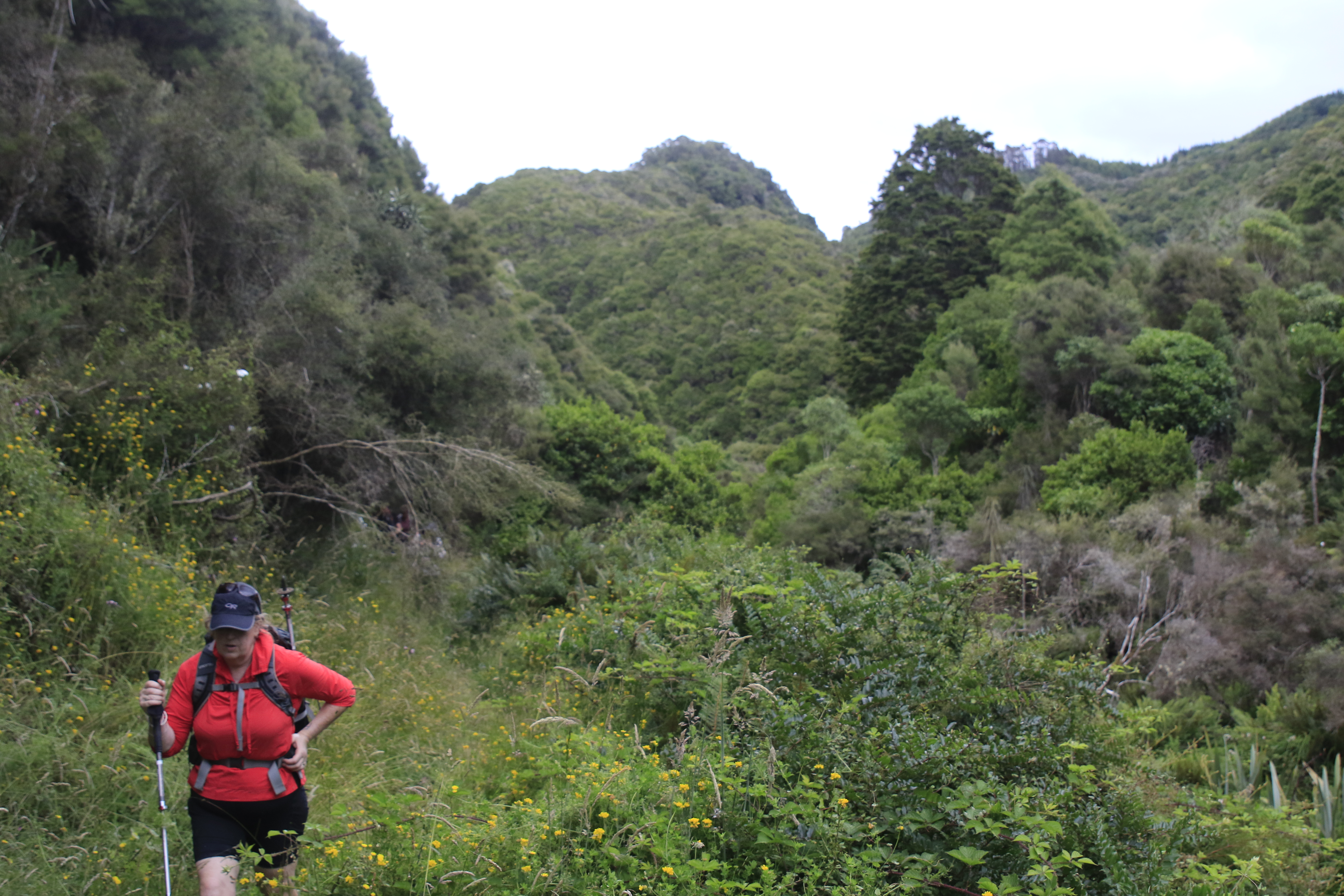
Following Careys Creek from Black Gully to Evansdale was trip #3 of 100 trips in October 2022 and as I had missed the trip (we were on weekend trip #2 of 100 trips) Three of us decided it was time to walk this track that I'd not completed before.  Starting at Double Hill the track initially winds its way through a tunnel of flowering manuka before dropping a knee jarring 100m downhill to Black Gully. The descent is made slightly easier with a number of steps cut into the bank making for a fast descent over a reasonably short distance.  We made the small detour to Black Gully Dam which was built in 1912 along with 17 km of pipeline to give water to the Seacliff Mental Hospital.  The flow to the hospital was gravity fed and not always successful due to the distance and terrain the pipe traversed.  After a fire at the Seacliff Hospital in 1942 with the loss of 37 lives, it was decided that a more reliable form of water supply was needed.

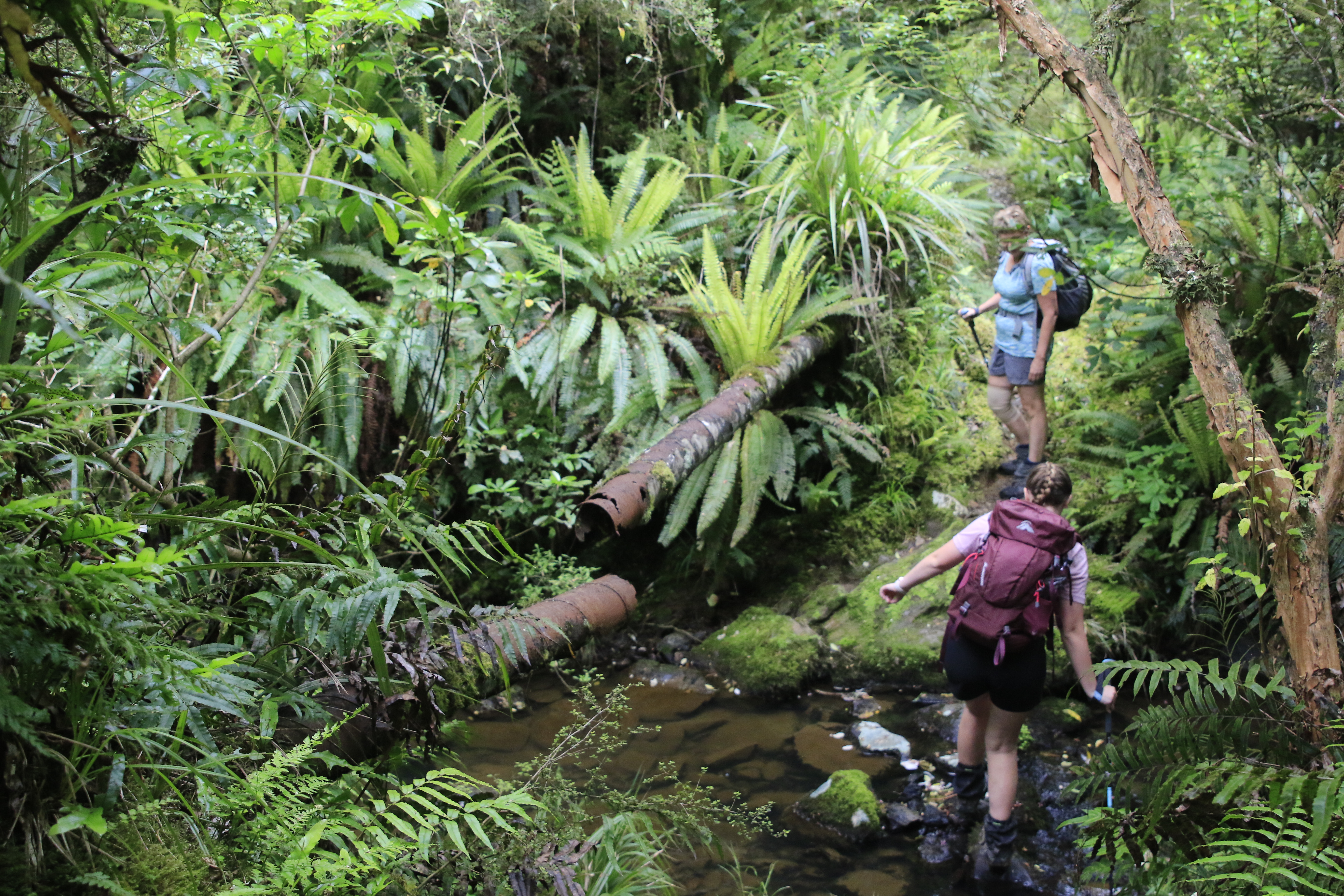
From the dam the track follows the old pipeline, crossing the stream often.  It is easy to see how difficult the terrain  made it to install and maintain the pipeline around 100 years ago.  There are numerous places that the pipeline is broken and these made the walk along the track more interesting.
The first part of the track is very pleasant walking between the moss and ferns beside Careys Creek.  The creek winds its way around slippery rocks and through numerous deep pools that look perfect for a dip in the clear water.  At this time of the year, the Careys Creek track is good for mushroom enthusiasts with a large variety of fungi to see. Not knowing the names of the mushrooms we saw, all I can say is that we saw  small perfectly round marble sized red fungi, large red and white spotted ones, grey frilly ones, large cream coloured ones and round white doughnut shaped ones.  We passed a number of fallen logs spouting whole cities of fungi.

As the track continues down the valley, the track moves from native bush to open grassy meadows and back into the bush with numerous stream crossings interspersed with the odd patch of pine forest.  After the lush greens of the native bush and bright sunshine of the grassy meadows the pine forest is dark and ominous.  It was good to pass through the pine forest quickly and back into the sunshine again.

From about half way the track drops into the creek and continues along the creek bed, crossing from one side to the other.  Keeping dry feet became impossible and it was refreshing as the water filled our boots and helped to cool us down. The track would climb out of the creek bed for a short distance then drop back in again.
 
There were patches of mud to negotiate, however the numerous creek crossings were good to wash the mud off.  In places the pipeline would disappear while in other parts we needed to continually step over it.  The pipeline often sat on top of the rocky ground like a snake, closely following the creek bed while other times it was raised above the ground.    All the time we continued to follow it down the valley.

Once we reached where the Honeycomb track joined the Careys Creek track the going became easier with less creek crossings and less mud.  We stopped for lunch beside the creek.  While enjoying the coolnes of sitting near the creek on a hot day we saw a couple of freshwater lobsters moving about in the clear water.  It is surprising how small the cracks and holes the lobster can disappear into under the water. Feeling replenished from lunch we continued down the track, in and out of the water for another hour until we reached Evansdale.  All up the trip was around 10km and took 4 hours (including stops). 

Tuesday, December 13, 2022

#18 of 100 trips for 100 years - Burns Track / Mountain Road (Track) / Rongomai / Evansdale Glen 11 December 2022

With heavy rain the night before and then waking up to low cloud this morning, it wasn't surprising that only three hardy souls turned up for what can only be described as a trip of many parts.  The results of last night's rain was obvious right from the start as the Pipeline Track, where we had walked on a dry surface only a month earlier during trip #9/100, was now slippery with a thin layer of mud.  After only 20 minutes walking on the Pipeline Track we reached the start of the Burns Track and from here the real work began. 

The Burns Track has always had a reputation of being muddy and while I'd not been on it for a number of years, I was pleasantly surprised to find that while there was plenty of mud to contend with, it wasn't difficult to avoid most of it.  The track has been well maintained with a number of channels dug to help drain the water and the vegetation has been cut back reasonably recently with one substantial section of 'board/branch walk'.  We made good progress and reached the Burns Saddle in around 40 minutes.  

It was on this section that we startled a couple of small pigs relaxing on the track.  The pigs were very quick to dive into the scrub as soon as they became aware of our presence.  The track follows the contour around and crosses the Burns Creek before climbing up a short but steep section to the junction of Rustlers Ridge where a morning tea stop was called and we got to have a short break (we had crossed here about a month ago on trip #9/100).

Continuing on the Burns Track, we headed towards Swampy Ridge with the track starting to deteriorate with larger and deeper patches of mud but mostly we were able to skirt around the edges of it.  On this section we had another encounter with wild life, this time we surprised a family of goats which took off in all directions and for some time we could hear them crashing through the undergrowth trying to regroup and move away from us at the same time.  We passed the steel stile to no where and continued onto Swampy Ridge where we turned towards Sleepy Hollow and the Silver Peaks. This is where we really encountered the mud, making anything we had already been through on the Burns Track seem insignificant.  It felt like the mud went on and on with some hilarity along the way, seeing who could avoid the worst of the mud and who would go in the deepest. 

 Everything must end eventually and so too did the mud. As we got nearer to Hightop, it was with relief when we entered the golden tussock.  This was a really enjoyable part of the track to walk along as it reminded me a lot of what the Silver Peaks looked like 25+ years ago when the all the tops were covered in this tussock and we were able to wander at will down any of the ridges. A bonus was that we were past the mud and were able to walk along without having to be careful of every step taken. 

We made a small detour off the track and up to Hightop where we stopped for an early lunch at 11.30am in the sun. We nestled amongst the golden tussock looking towards the tops of the Silver Peaks and reminisced about some of the trips we'd been on over the years into the Silver Peaks and some of the people that had been on those trips.  It was during lunch that Rob discovered he had left his cup at home and his tea was too hot to drink straight from the thermos.  Feeling sorry for him having carried his hot tea all this way and still with quite a distance to go,  I donated my lunch box to him to use as a cup and Rob was able to enjoy his hot tea.  
Feeling replenished we shouldered our bags and continued on our journey.  Finding our way down from Hightop involved a small amount of bush bashing as the track is overgrown and difficult to follow in places but all to soon we found ourselves on Mountain Road. This next part of the trip was the section that I was least looking forward to as it involved about 6km of walking along Mountain Road.  I must confess that it wasn't as monotonous as it has been in the past due to the fact that all the pine trees have been harvested which meant we weren't walking in a tunnel of trees but instead had good views and were able to amuse ourselves by picking out distant landmarks as we walked. 
After about an hour of road walking we reached the Rongomai track which starts off on a gentle slope then descends steeply down a defined ridge.  Thankfully there were a few well placed trees to hold onto but mostly it was a careful descent making sure to stick to the track as there was no room for error with extremely steep sides.  At one stage we heard a snuffly snort almost under our feet and not wanting to see what made the noise we quickened our pace and eventually we had dropped 300m to emerge at Careys Creek.  The final stretch of track involved a 3.5km walk along the grassy bank of Careys Creek winding in and out of the bush. This part was what we affectionately named the 'boot cleaner' section as the long grass wiped all the mud off our boots and we emerged from the track looking a lot cleaner than we might have otherwise been.  All in all a fun day out where we walked 19.2km in a little over 6 hours.  

Otago Harbour Cycleway 30 October 2023

With my sister in town, it seemed a shame to waste a calm, sunny day so the two of us hopped on a bike each to enjoy the recently opened 32k...