Wednesday, June 28, 2023

#66 of 100 trips for 100 years - Taieri River Track 25 June 2023


The Taieri River Track was opened in 2001 with the first OTMC trip to the track in 2002 and since then the track has been  a regular feature on theOTMC trip card.  Starting today's walk at sea level from Taieri Mouth were 16 people who wandered past some cute holiday cottages in the Taieri Mouth township before following the track alongside the wide, slow moving Taieri River.  With a near high tide, the water lapped at the edge of the track in places and in other parts there was some silty sand flats showing.
In the early stages of the trip, there was some jockeying for position as people found their walking rhythm and started to chat to the people in front and behind them.  The track initially winds it's way in and out of a number of small bays and with the native bush right down to the edge of the river, we enjoyed stopping to admire the wonderful views when able to get views of the river through the trees.    In places, the tidal nature of the river has created some lovely wetlands and boardwalks have been built to protect this fragile environment while also allowing us to get a closer view of the salt marsh.
After the first half hour of this easy walking, the track starts to climb, weaving in and out of a number of gully's as it steadily rises, eventually reaching a height of almost 200m.  At the highest point we are rewarded with a seat placed to make the most of the stunning views of the river, coastline and inland to the Silver Peaks. It was here that the unanimous decision was made to stop for morning tea to give us time to take in these wonderful views.
After all the effort of climbing to 200m from sea level, the track then drops steeply via zig zags over the next kilometre back to sea level.  John Bull Gully is a peaceful grassy cove in a bay on the edge of the Taieri River with a couple of picnic benches and is the perfect place for lunch while watching the river lazily flows past.  With the native bush coming all the way down to the rivers edge and reflecting in the dark waters of the Taieri River, it truly is a magical place to be. 
I can see that during the summer months, this would be a safe place for swimming and despite the sunny skies, the winter temperatures meant that no one wanted to take the plunge. There are some interesting headlands easily accessible from John Bull Gully and most of the group took the opportunity to explore as far as possible, taking care on the slippery rocks. 

There was some reluctance to leave after lunch as the track immediately heads steeply 200m up hill back to the lookout.  Everyone took the hill at their own pace and the climb did not take as long as first thought.  It helps that the native bush is so pretty, particularly with the sun shining through the canopy and highlight all the different greens, from lime through to the almost black.  Before we realised it we were back at the seated lookout.
An unspoken decision was made to stop here again to give us more time to enjoy the beautiful views set out in front of us. Despite the fact we had only had lunch not long ago, it was time to get the drink bottles and snacks out in order to delay our leaving as long as possible.
All good things must come to an end and eventually it was time to move on with a steady descent down the track as it winds its way in and out of the gully's.  The benched track is in surprisingly good condition for winter with very little mud and a number of steps making it easy to negotiate before reaching the rivers edge. 
Once at the rivers edge, it was a fast walk back to the start of the track at Taieri Mouth township.  All up we had walked 10.5km with a total of 400m ascent over 4.5 hours. 

Wednesday, June 21, 2023

#64 of 100 trips for 100 years - Nicols Creek - McQuilkans - Ben Rudd’s - Pineapple Track 18 June 2023


The trip had an unusual start as we stopped the car along the way to pick up a few stragglers who almost got left behind. This meant that once we reached the Nicols Falls car park, we had a few extra people than first thought.  In the end, there were 12 people keen for a fun day walking in the Flagstaff area under overcast skies.  We started by taking the Nicols Falls track which follows a wide graveled four wheel drive track before turning into a narrow walking track which climbs steeply as it winds it's way through native bush up the hill.  At the track junction we opted to visit Nicols Falls. 
From the falls, we crossed the creek and clambered up the benched track on the true left to gain the ridge and the Moon Track. The Moon Track has been enhanced by the mountain bikers with long sweeping bends, however we stuck to the Moon tramping Track which climbs straight up the ridge, crossing the mountain bike track regularly.  When crossing the mountain bike track, we kept an ear out for mountain bikers, however we saw no one so continued our climb, popping out of the bush to follow the fence line to the seated lookout without incident.
We stopped at the seated lookout for a brief morning tea break, however the cold wind meant we didn't linger long before packing up and continuing uphill on the Moon Track.  The views over the city from the seated lookout are spectacular of the city interrupted only by a small amount of cloud. 
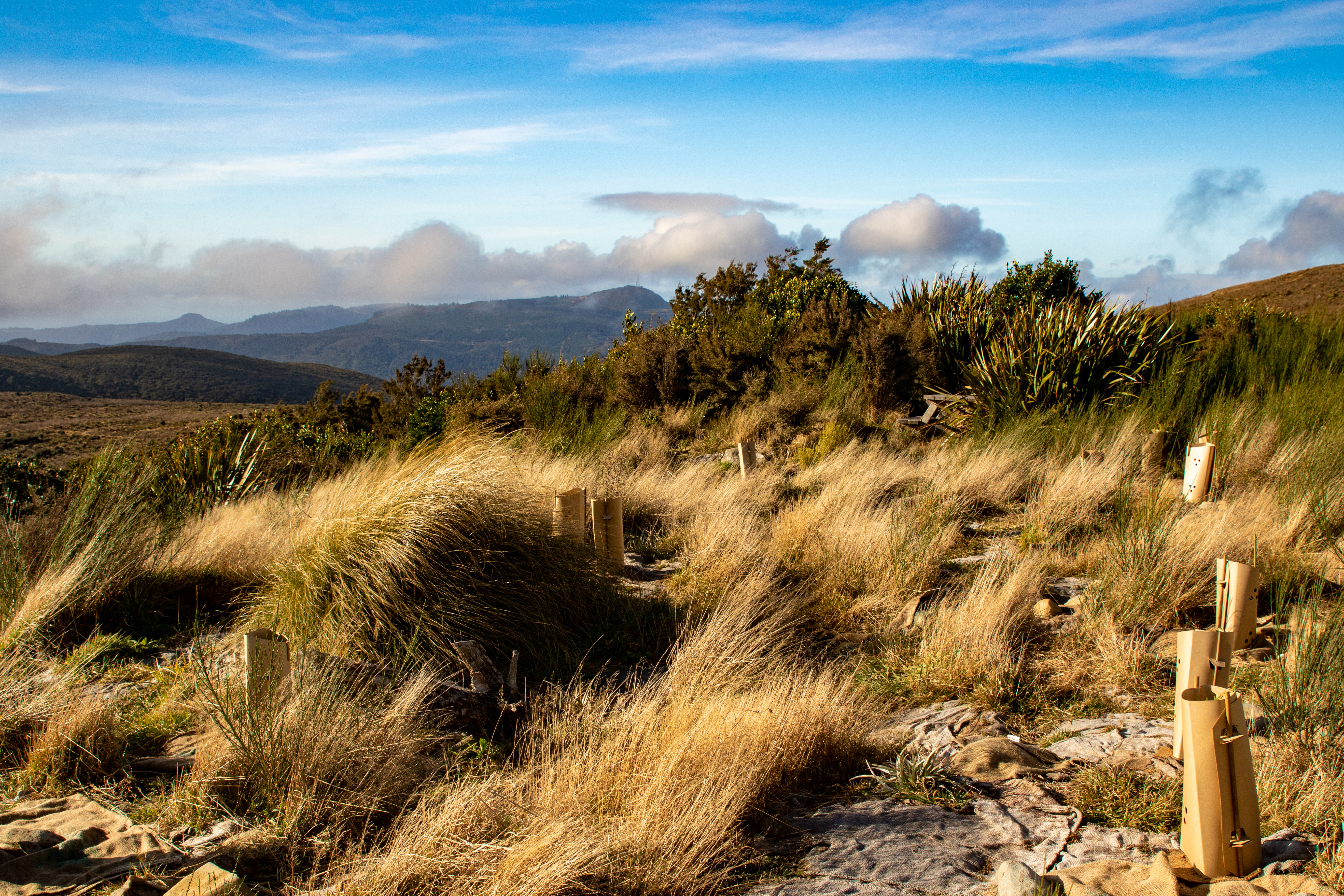
Shortly after setting off from morning tea, the track enters the native bush again and we continued climbing up the Moon track.  After a short distance the Moon walking track continues to climb directly up the ridge, however we missed the turn off and followed the mountain bike track instead which wound it's way in and out the gully's following the contour line which added another almost kilometre or two to our journey.  At times the cloud rolled in and we walked in the mist, barely able to see the person in front and then the mist would clear and the world was revealed again.  As we left the bush and ventured into the golden tussocks on our approach to the summit ridge, 570m climb from where we had left the cars the cloud rolled back to reveal a blue sky albeit it with a cold wind.  
We had a second brief morning tea break sheltering amongst the tall tussocks with views overlooking the Taieri Plains and Mosgiel with Maungatua and the Silver Peaks in the distance.  Our second morning tea break was as short lived as the first because the cold wind meant that no one wanted to take longer than necessary and we were heading down the McQuilkans's track with the top part of the track.  The top part of the McQuilkan's track is in the open tussock but is also badly rooted over the wild pigs.
Not long after leaving the main ridge, the track re-enters the native bush, twisting and turning between large limbed, paper dripping fushia and tall, pencil thin, straight manuka trees.  The track crosses a couple of small creeks and through a number of extremely muddy sections before joining the Possum Busters track 200m below the summit.  We had thought to have lunch somewhere around this area but the muddy track and dripping wet bush didn't appeal so we continued on the Possum Busters track around to the bottom of the Jim Freeman track
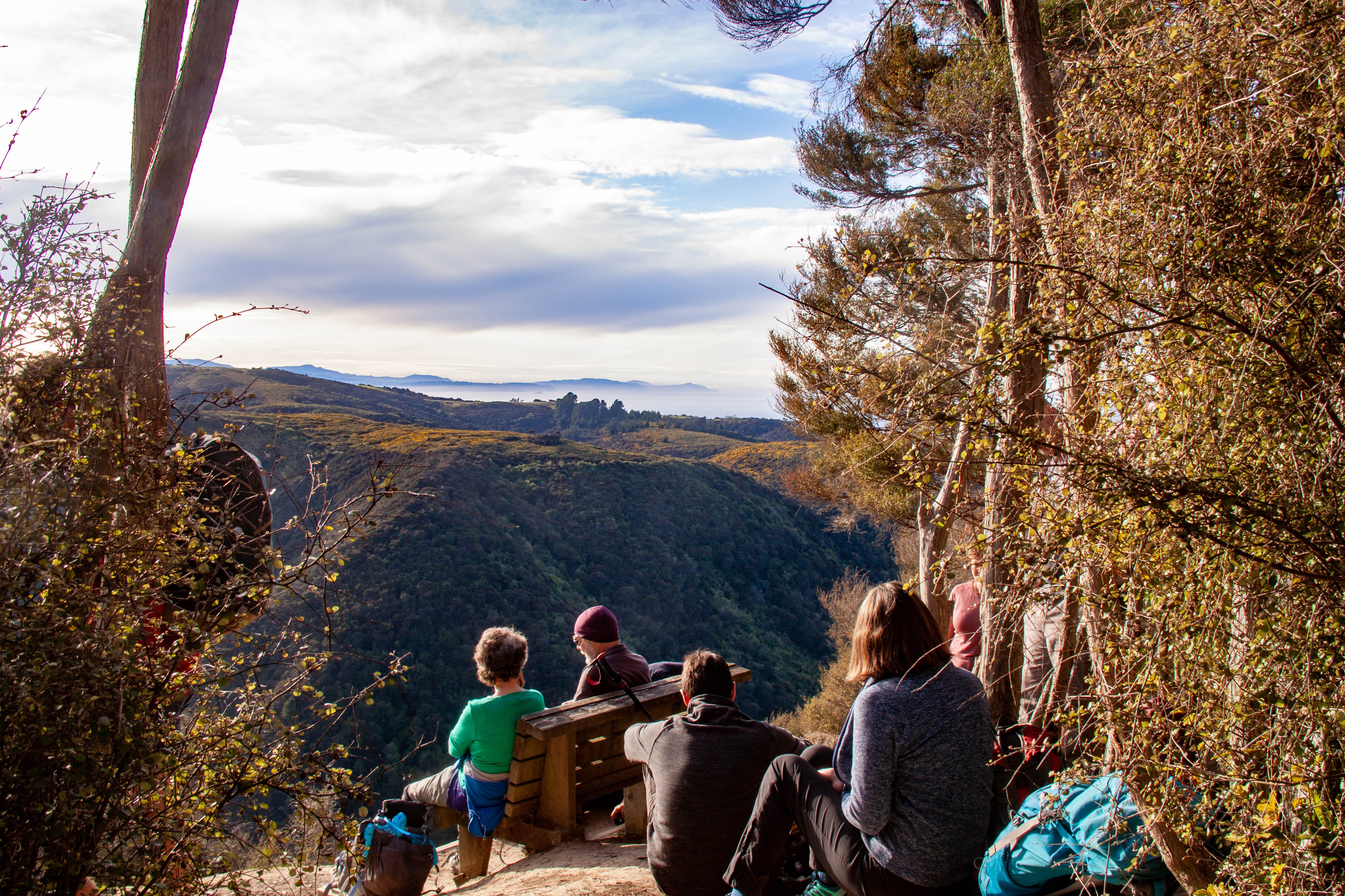
This section of track had another couple of creek crossings with nicely placed stones to skip across, although some concentration was required to keep upright  and the feet dry as the stones were slippery.  There was also a couple of large muddy sections to avoid but otherwise we reached the Jim Freeman track unscathed.  If we had thought we had already done most of our climbing, however we were wrong as the Jim Freeman track climbs steeply 200m through native bush and Rhododendrons to the Ben Rudd Shelter which was the perfect spot to sit in the sun, out of the cold wind for lunch.
After a leisurely lunch, we continued another 60m uphill from the shelter to the Fire Break track where we stopped for a look at the recent Beech tree planting by the Ben Rudd's Trust.  Despite the cold wind we also took this opportunity to pick out the visible parts of the Silver Peaks including Pulpit Rock, Long Ridge, Powder Ridge and Silver Stream. 
From the Fire Break track, it was a short walk to the Cross Track and onto the Flagstaff Walkway with more fantastic views overlooking Dunedin City and the surrounding hills, including Kapukataumahaka/Mt Cargill, Herewaka/Harbour Cone and Poatiri/Mt Charles.  This has always been my favourite view of the city, however today we were buffeted by a strong, cold wind and, at times, it was hard to stay upright with the blustery wind trying to blow us into the tussock. 
Keeping our balance and pushing on, we skirted around the knob and down to the Pineapple Track where we ventured up to Pineapple Point before taking the Pepper Tree Track,  This track dropps sharply down 80m before entering the relative calm of the native bush before continuing on down a benched track through the bush and dropping 260m towards the road.  This was the drier, more sheltered side of the hill  and we were happy not to encounter any mud.
This section of track eventually joined up with the Nicols Falls track before reaching the road back at the cars.  It had been a fun day in the hills with around 900m of climbing and 13.5km taking us 5.5 hours of walking. 
 
GPS route of our trip


Sunday, June 18, 2023

#63 of 100 trips for 100 years - Purakanui Inlet 17 June 2023


The walk today was a short 7km stroll around the Purakanui Inlet which had 16 people enjoying the views and winter sunshine.  The walk was an easy one as it follows the track and some roads around the waters edge and we were able to stop often to admire the stunning vistas along the way.  Parking at the head of Purakanui Inlet, the track weaves it's way around the coast, in and out of a number of small bays. 
The tide was in and the water was lapping at the path in places but our feet remained dry and we were able to see the bottom in most places. With the winter sun shining brightly and the blue skies made the temperatures feel warm so we stopped at regular intervals to really appreciate the beautiful setting.
After 20 minutes of walking, we reached the township of Purakanui and continued following the track around the waters edge where we passed a number of boat houses including a 140 year old historic cottage nestled on the edge of the inlet. The beautifully kept cottage is an airbnb and would make an idyllic place to stay for a summer's weekend. 
After the Purakanui township, we descended the track from the corner of Hill Street and continued around to Potato Point along a narrow, grassy trail.  As we reached the end of the grassy trail, a few of the group opted to stop and have a snack at a seat slightly uphill, away from the high tide mark. 

The rest of the group continued on rock hoping around to the bluffs of Potato Point.  The tide was turning with the waves crashing onto the rocks making for an exciting journey around the point. Once we had reached as far as we could go, those that had carried on this far, found a spot out of the spray and settled down for a brief snack break before turning around and retracing our steps back to the seat where we had left the rest of the group.
The return journey back to the cars saw us following the same track around the edge of the inlet, weaving in and out of all the small bays.  Of course there was time to stop to admire the views with different lighting from the lowering sun. It was also a good opportunity to walk and chat with different people and the time passed quickly. 
Before we knew it, we were back at the cars two and a half hours after starting out.  Everyone agreed that this had been a perfect walk on a sunny winters afternoon with a great group of people and is a trip that I'd be happy to do again.

#62 of 100 trips for 100 years - Government Track 11 June 2023 (by Jade Pettinger)


Winter has well and truly arrived in the south! A week of negative temperatures and thick frosts didn’t stop 19 hardy trampers from gathering at the club rooms bright and early on Sunday morning, keen for a day in the hills. Pleasantries were exchanged, plans were made and trampers were bundled into cars, ready to hit the road.
The usual cruisy drive along the Taieri Plains was made slightly more treacherous by the thick frost from the night before. Before long we were winding our way up the Waipori Gorge, in the shadow of the hills towering above us. It was like emerging into a winter wonderland - we were surrounded by a beautiful hoar frost, making everything look like it was part of a fairytale. Our child-like excitement meant we didn’t even feel the cold as we set off, instead our energy was focused on admiring the beauty around us
The Government Track was built in the 1860’s to provide access to the Central Otago Goldfields. With the main mode of transport in the 1860’s being bullock, the track gently climbs up the hill as opposed to the steep, scrambly tracks we are more used to. The track starts with a small, steep section of switchback, but once we had conquered that it was time to begin the long slog up the hill. From here, the wide track meanders through the bush as we traversed through beech and mānuka forests above the Waipori Gorge. Although the gradient was gentle, the climb felt relentless as we had around 500m in elevation to gain in just 9km.
The steady climb soon got the blood pumping and despite the near negative temperatures, layers were starting to be shed. Around the 45 minute mark, we emerged from the bush onto a frozen paddock, with our first (and only) viewpoint in front of us. The layers of the Waipori Gorge were striking, highlighted by the morning fog that was lingering in the depths of the valley. One bonus about winter tramping is we are often walking on top of frozen mud, rather than trudging through ankle deep sludge, which was exactly the case as we crossed the exposed pasture.
We found a sheltered perch on the side of the hill to have a quick nibble, this was also a chance to mingle with friends who we hadn’t yet had a chance to talk to as they became lost in the line of trampers. A passing shower meant wet weather gear was donned before continuing our long trek uphill.
 
The remainder of the uphill trek passed by quickly, and rather uneventfully. The dense bush surrounding us, along with the many voices bouncing off the steep walls of the gorge made it easy to get a little disorientated, although thankfully the track was well-maintained so it was near impossible to wander off in the wrong direction.  The occasional windfall or small stream to negotiate kept us on our toes, while searching for fungi kept our minds occupied. Some eager eyes spotted a violet pouch fungus - a magnificent purple mushroom, unlike any I had seen before.
All of a sudden we rounded a corner and found ourselves at the end of the track. And just in time as well, it was past lunchtime and our stomachs were starting to protest. Lunch was a fairly quick affair as we shivered in the shade of the hill, keen to get going. While we could have returned via a different track, we opted to head back the same way we came as we would be less exposed should the weather turn earlier than forecast. As it was all downhill, we made good timeand before we knew it was emerging onto the paddock we crossed early this morning. What a difference a few hours makes - the sun was streaming down on us and not a trace of the frost from earlier this morning.
Afternoon tea was enjoyed soaking up the late afternoon sun before slipping and sliding our way down the hill. As the ground beneath our feet had thawed, so had the mud which turned our relatively straightforward walk into a treacherous mud pool. We each had our own strategy on how to best avoid the mud, some were arguably more successful than others but we all managed to stay on our feet.

5 ½ hours and 19.3km later we arrived back at the cars, pleased to be able to rest as our feet were beginning to feel a little weary. To our surprise the hoar frost had melted, however it certainly didn’t feel any warmer in the depths of the gorge so we wasted no time in climbing into the vehicles and heading home. 

Written by Jade Pettinger

Saturday, June 10, 2023

#61 of 100 trips for 100 years - Hoopers Inlet & Nyhon Track 5 June 2023


About 30 years ago, in the early 1990's I had helped put a sign in at both ends of the Nyhon Track but I had never actually walked the track so I was keen for today's walk. There hadn't been a trip to the Nyhon Track for a while which is maybe why there was a large group of 17 leaving from Hoopers Inlet to walk across a land bridge over the salt marsh. 

At the end of the land bridge, we crossed a style and the gentle slope turned abruptly into a very steep 200m climb straight up Dicks Hill.  The track follows the fence line and is a slippery climb up through paddocks with care needing to be taken to ensure we stayed upright.  The slope was unrelenting and as we climbed higher the view began to unfold behind us with a panoramic view of Hoopers Inlet, Allans Beach  with the bulk of Mt Charles/Poatiri dominating the skyline.
Reaching the false summit  just below Dicks Hill was a welcome place to rest, catch our breath and take a few photos before continuing on to the top where we crossed another style and followed the track down to Sandymount Road where memories were retold and photo's taken as we took the stairs down the bank to the road that I had helped dig 30 years ago.
The next section of the trip was a short road walk up Sandymount Road to the historic lime kilns where we took the 5 minute detour to see the kiln which had been built in the 1860's and was in use until the early 1900's.  As the weather was nice and it was a warm, sheltered spot so we took the opportunity for a morning tea break. 
After our short break and a team photo or two we headed back to the Sandymount Road which we followed it uphill to Highcliff Road and then another 20 minutes to the Harbour Cone track. It was along this stretch of road that a light misty rain started to fall and then the cold wind picked up so the possibility of climbing Harbour Cone was dismissed and instead we plunged down the hill, threading our way through some ancient marcrocarpa trees to the stone ruins of an historic house where we each found a sheltered spot amongst the stone walls to eat lunch.  

Thankfully the light rain had stopped but the temperature remained cold so lunch was a rather hurried affair with  everyone keen to move on before becoming too cold.  After lunch we back tracked for a short distance before following the fence line down into a gully which had us scratching our heads a little as the track seemed to lead into a patch of native bush with no obvious way out.  In the end we took the path of least resistance that headed in the direction we wanted to go i.e. downhill.  It took more time than expected to get down through the bush with 17 people clambering over roots and through vines while slipping and sliding down the hill.  Eventually we all emerged from the bush at the bottom of the hill where we regrouped before wandering through the paddocks, around the boggy bits, crossing a couple of fences and over a small hill or two.  
The track took us back onto flat land and by following the markers we completed a loop by reaching the path that we had followed on the way in, just where it reached the steep climb up Dicks Hill.  The temperature down in the gully, out of the wind was much warmer than higher on the hill and we were able to take our time and enjoy the scenery around us. 
From here it was only a short walk back down the gentle slope, across the land bridge and back to the cars four hours and 8.4km after starting.  This is a part of the peninsula that I had not spent much time on or  tracks that I had walked before and I had enjoyed the day with wonderful views of the surrounding landscape, particularly of areas that we have recently visited during the #100 trips

Otago Harbour Cycleway 30 October 2023

With my sister in town, it seemed a shame to waste a calm, sunny day so the two of us hopped on a bike each to enjoy the recently opened 32k...