The trip had an unusual start as we stopped the car along the way to pick up a few stragglers who almost got left behind. This meant that once we reached the Nicols Falls car park, we had a few extra people than first thought. In the end, there were 12 people keen for a fun day walking in the Flagstaff area under overcast skies. We started by taking the Nicols Falls track which follows a wide graveled four wheel drive track before turning into a narrow walking track which climbs steeply as it winds it's way through native bush up the hill. At the track junction we opted to visit Nicols Falls.
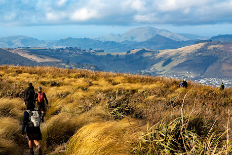
From the falls, we crossed the creek and clambered up the benched track on the true left to gain the ridge and the Moon Track. The Moon Track has been enhanced by the mountain bikers with long sweeping bends, however we stuck to the Moon tramping Track which climbs straight up the ridge, crossing the mountain bike track regularly. When crossing the mountain bike track, we kept an ear out for mountain bikers, however we saw no one so continued our climb, popping out of the bush to follow the fence line to the seated lookout without incident. We stopped at the seated lookout for a brief morning tea break, however the cold wind meant we didn't linger long before packing up and continuing uphill on the Moon Track. The views over the city from the seated lookout are spectacular of the city interrupted only by a small amount of cloud. Shortly after setting off from morning tea, the track enters the native bush again and we continued climbing up the Moon track. After a short distance the Moon walking track continues to climb directly up the ridge, however we missed the turn off and followed the mountain bike track instead which wound it's way in and out the gully's following the contour line which added another almost kilometre or two to our journey. At times the cloud rolled in and we walked in the mist, barely able to see the person in front and then the mist would clear and the world was revealed again. As we left the bush and ventured into the golden tussocks on our approach to the summit ridge, 570m climb from where we had left the cars the cloud rolled back to reveal a blue sky albeit it with a cold wind. We had a second brief morning tea break sheltering amongst the tall tussocks with views overlooking the Taieri Plains and Mosgiel with Maungatua and the Silver Peaks in the distance. Our second morning tea break was as short lived as the first because the cold wind meant that no one wanted to take longer than necessary and we were heading down the McQuilkans's track with the top part of the track. The top part of the McQuilkan's track is in the open tussock but is also badly rooted over the wild pigs.
Not long after leaving the main ridge, the track re-enters the native bush, twisting and turning between large limbed, paper dripping fushia and tall, pencil thin, straight manuka trees. The track crosses a couple of small creeks and through a number of extremely muddy sections before joining the Possum Busters track 200m below the summit. We had thought to have lunch somewhere around this area but the muddy track and dripping wet bush didn't appeal so we continued on the Possum Busters track around to the bottom of the Jim Freeman trackThis section of track had another couple of creek crossings with nicely placed stones to skip across, although some concentration was required to keep upright and the feet dry as the stones were slippery. There was also a couple of large muddy sections to avoid but otherwise we reached the Jim Freeman track unscathed. If we had thought we had already done most of our climbing, however we were wrong as the Jim Freeman track climbs steeply 200m through native bush and Rhododendrons to the Ben Rudd Shelter which was the perfect spot to sit in the sun, out of the cold wind for lunch. After a leisurely lunch, we continued another 60m uphill from the shelter to the Fire Break track where we stopped for a look at the recent Beech tree planting by the Ben Rudd's Trust. Despite the cold wind we also took this opportunity to pick out the visible parts of the Silver Peaks including Pulpit Rock, Long Ridge, Powder Ridge and Silver Stream. From the Fire Break track, it was a short walk to the Cross Track and onto the Flagstaff Walkway with more fantastic views overlooking Dunedin City and the surrounding hills, including Kapukataumahaka/Mt Cargill, Herewaka/Harbour Cone and Poatiri/Mt Charles. This has always been my favourite view of the city, however today we were buffeted by a strong, cold wind and, at times, it was hard to stay upright with the blustery wind trying to blow us into the tussock. Keeping our balance and pushing on, we skirted around the knob and down to the Pineapple Track where we ventured up to Pineapple Point before taking the Pepper Tree Track, This track dropps sharply down 80m before entering the relative calm of the native bush before continuing on down a benched track through the bush and dropping 260m towards the road. This was the drier, more sheltered side of the hill and we were happy not to encounter any mud. This section of track eventually joined up with the Nicols Falls track before reaching the road back at the cars. It had been a fun day in the hills with around 900m of climbing and 13.5km taking us 5.5 hours of walking.
GPS route of our trip


No comments:
Post a Comment