Sunday, September 26, 2021

Day Ninety Three Waikouaiti

Since I had managed to only walk about a third of the streets in Waikouaiti yesterday, I returned today and walked another 13 streets.

1233. Court Street
1234. Malloch Street
1235. Park Street
1236. Pratt Street
1237. Mount Street
1238. Kildare Street
1239. Dame Street
1240. Geelong Street
1241. Collins Street
1242. Bourke Street
1243. Seddon Street
1244. McGregor Street
1245. Reid Street

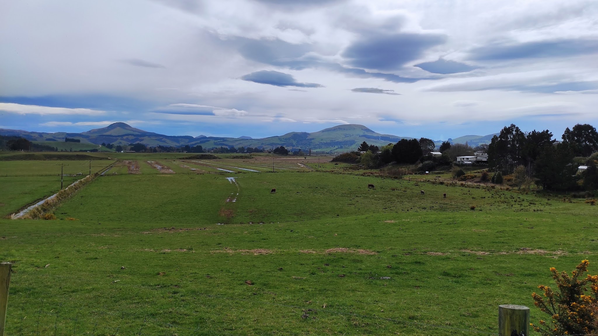
I started walking the streets near the Waikouaiti School first.  These streets are on a small hill with views looking down to the Hawksbury Lagoon, where I had been walking yesterday.  The township of Waikouaiti has been built around the lagoon. 
 
Looking one way from the top of the small hill is the lagoon and the other is looking out over farmland.  Looking at the map, I believe the hill on the left is Pahatea Durden Hill and the hill on the right is Mt. Baldie. 
 
Just on the edge of the township is the Waikouaiti racecourse. Horse racing has been popular here since 1862 with the most popular races for many years being the New Years Day races, however that has been stopped and there is no longer any horse racing here.
 
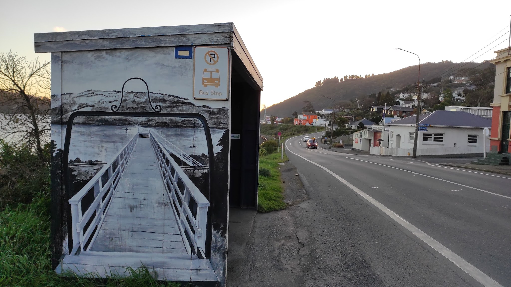
The railway line runs beside the race course and divides the township of Waikouaiti in half.  This railway line is the part of the Main Trunk Line which runs the length of the country.  This part of the railway line was completed in the 1870's.
On the other side of the township is State Highway One.  This is the main road that also runs the length of the country.  This piece of road can be very busy but once you step onto the side streets, the township has a much quieter and peaceful feel to it.
 
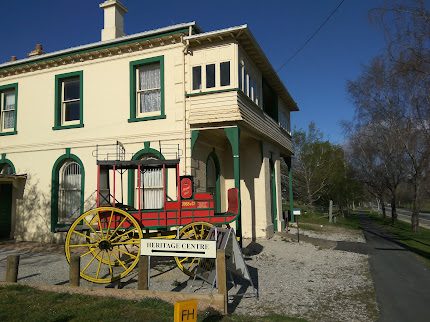
I walked past the old Bank of New Zealand building.  The building was built in the 1870's and has been left untouched since it's last upgrade in 1927.  It is part of the Waikouaiti Coast Heritage Centre now and is open to the public.  The Cobb and Co. coach outside the Heritage Centre is a replica built by one of the Waikouaiti locals.  The Cobb and Co. stage coaches regularly traveled between the Waikouaiti and Dunedin
Further down the road from the old BNZ building is the old Post Office building.  Built in 1907, the Post Office not only had letters but also telegraph and morse code, and later a small manual telegraph exchange was installed. The Post Office was closed in 1989 and now the building has been turned into a home. 
I didn't see any unusual letterboxes today but I did see these minions made out of old car tires. 

 And lastly I have included the map of Waikouaiti with the streets I have walked highlighted in red.  This shows where the racecose is and how the township has been built around the lagoon.  I still have the streets on the right to walk.

Distance walked:  8 km         Walking time  1 hr 26 mins  

Total distance: 766.2 km          Total walking  143 hr 35 mins 

Saturday, September 25, 2021

Day Ninety Two Waikouaiti

The day was warm and sunny so I headed to Waikouaiti where I battled the wind to complete 15 streets today.

1218. Rockal Street
1219. Kilda Street
1220. Henry Street
1221. Jones Street
1222. Fell Street
1223. Thomas Street
1224. Scotia Street South
1225. Scotia Street West
1226. Scotia Street North
1227. Stewart Street
1228. Matanaka Drive East
1229. Matanaka Drive
1230. Beach Street
1231. Brown Street
1232. Anne Street

I realised that I had missed a couple of streets in Karitane last weekend so I went back to walk them today.  Kilda Street and Rockal Street border Huriawa Pa.  The Pa is a fortified Maori village from the late 18th century.  While there are no buildings at the Pa site, it is an historic site with walking trails throughout the area.  

The views from the road leading to Huriawa Pa climb a small hill which gives fantastic views along the coastline.  Once I had walked the two streets in Karitane, I drove to Waikouaiti where I began walking again.

Waikouaiti is a small township at the northern boundary of Dunedin.  Waikouaiti is a Maori name that means "braided streams" (Wai-koua-iti) or "small bitter waters" (Wai-kawa-iti). Waikouaiti is home to the first farm by European settlers in the Otago region in 1840.  Today, Waikouaiti is still surrounded by farmland. 

Once you walk off from the main road through Waikouaiti, the surrounding streets have a calm peaceful feel to them with very little traffic. 

However one of the downsides of walking the streets of Waikouaiti are the length of the streets.  The streets are in a grid formation with some of the streets being 2km in length.  I feel like I had done a lot of walking today but didn't complete many streets.

To avoid walking on the same roads, I took a 'shortcut' through the Hawksbury Lagoon.  The first settlers in to the area in 1840 drained parts of the lagoon to create farmland however in 1883 the community stopped further drainage and in 1912 the lagoon became a reserve. 

The lagoon is very large and home to a variety of birds and at different times of the year, large numbers of birds use the lagoon as a stopping place during their migration.  Today I only saw black swans. 
 
Once past the lagoon, I walked Beach Street which took me to the Waikouaiti Beach where the ship Magnet arrived with the first European settlers to the area. The beach, itself, is 4km long.  Thankfully I did not need to walk the length of the beach as the street goes only a small part of the distance.

And once I had reached the beach, I had to walk the long straight streets back to the main road.  The photo's don't show it but there was a strong wind today and I was walking into the wind along this street.  At times it felt like I was almost being blown backwards.

Waikouaiti is a town divided by the railway line with Scotia Street being on both sides of the line.  This is why there are three names for Scotia Street, depending on what side of the railway line you are walking.
 
I walked past this peaceful mini wetlands on the edge of Waikouaiti.  I could see pukeko and ducks in the wetlands and it was a beautiful place to stop and rest for a moment.

Near the beach, I walked past this monument which is honour the pioneers who arrived on the ship, Magnet, in 1840.

Waikouaiti has it's share of interesting letterboxes and these are some of the ones that I walked past today.  I particularly liked the bagpipe playing letterbox.


Distance walked:  12.9 km         Walking time  2hr 25 mins  

Total distance: 758.2 km          Total walking  142 hr 09 mins 

Thursday, September 23, 2021

Day Ninety One Ravensbourne

Another lovely day in Dunedin so I took the opportunity for an evening walk and returned to walk some more streets in Ravensbourne.  Today I walked 13 streets.

1205. Manuka Street
1206. Matai Street
1207. Junction Road
1208. Adderley Terrace
1209. Short Street
1210. Hinau Street
1211. Monowai Road
1212. Wanaka Street
1213. Wakatipu Street
1214. Totara Street
1215. Seddon Street
1216. Athol Place
1217. Ohau Street
 
Ravensbourne is on the side of the harbour that loses the sun in the evening, however the views more than made up for walking in the shadows. 
The streets of Ravensbourne are narrow and wind their way around the side of the hill.  One of the benefits of being on the hill is that I was rewarded with great views from every street I walked tonight.
As I walked the streets on this side of the harbour, I was able to look over at the sunny side and know that I have walked all the streets that I could see. I had walked the streets opposite in January and at the time, my challenge to walk every street in Dunedin seemed like an impossible task. Now I have walked around 3/4 of Dunedin's streets.

It was a lovely evening to be out walking and as I made my way down the hill, the city and harbour views continued to open out.  

Eventually I made it back to the bottom of the hill and walked along beside the road and railway line as the sun was setting. 
As I walked along beside the harbour and railway line, I was able to look over at Macandrew Bay which was still in the sunshine.  I have walked along the road as far as Macandrew Bay but I haven't walked the streets in Macandrew Bay yet. 

And finally I finished my walk by walking up a couple of the steep, narrow streets.  This photo doesn't show it, but this street is steep and a good challenge for the legs and lungs.

 
Today I walked past the Ravensbourne fire station.  This is a small fire station which is run by volunteers who give up their time to train and fight fires.  Even though it is still in the city, the volunteers would be first at a fire or car accident.  The fire bell out the front is a memorial to firefighters who have died while still being on active service.

I didn't see any interesting letterboxes on my walk today but there were a number of houses in Ravensbourne that had interesting things on their fences.  The residents of this house had lots of small windmills as well as ornaments on their fence.
And I am not sure why the residents of this house would have a fly stuck in a spider web as their fence. 
The residents of this house look like they have made their own unique fence ornaments.
The railway line runs through Ravensbourne and the Ravensbourne bus stop is cleverly painted as a tribute to the railway line.  One one side is the walking bridge over the railway line.  The way it is painted, it is made to look like you could walk over it and the other side has a lovely steam train.
The other street art that I saw on my walk today was this fox painted on a garage door. 

Distance walked:  4.5 km         Walking time  56 mins  

Total distance: 745.3 km          Total walking  139 hr 44 mins 

Tuesday, September 21, 2021

Day Ninety Seacliff & Karitane

Continuing on from my blog yesterday, today's blog post is about the streets that I walked in Seacliff and Karitane which are small townships further along the coast.  I walked the streets of these townships/suburbs as they are in the boundaries of Dunedin City.  I walked 24 streets.

1181. Russell Road
1182. Kilgour Street
1183. Palmer Street
1184. Barvas Street
1185. Halkirk Street
1186. Parata Avenue
1187. Rawhiti Street
1188. Kamura Street
1189. Seaforth Street
1190. Sulisker Street
1191. Roneval Street
1192. Harris Street
1193. Rona Street
1194. Karitane Reserve Road
1195. Scarp Street
1196. Grimness Street
1197. Stornoway Street
1198. Eris Street
1199. Kerr Street
1200. Barra Street
1201. Bernera Street
1202. Pentland Street
1203. Dunnet Street
1204. Coast Road

The second part of my walk today, saw me walking the three streets at Seacliff.  In 1884, the Seacliff Lunatic Asylum was opened.  At the time it was the largest building in New Zealand and housed 500 patients and 50 staff.  In 1889 Truby King was appointed medical supervisor and 'prescribed' fresh air, exercise, good nutrition and productive work to the patients.  By the 1940's the hospital became more like a prison where the treatment would be considered cruel today.  The old hospital grounds are a reserve and thought to be haunted by patients who were locked in their rooms and died when a fire broke out at the hospital in 1942.  The Seacliff Lunatic Asylum closed in 1971.  Today the small settlement has a quiet and peaceful feel to it.

After leaving Seacliff, I drove to Karitane to continue walking the streets.  Before reaching Karitane, I stopped at a lookout which gave me a good view of the township which is in the middle of this picture.  The Huriawa Peninsula is to the left of the township and juts out into the sea.  The peninsula was home to the Huriawa Pà which is a Maori fortified village. 

Karitane is a small seaside settlement located near the mouth of the Waikouaiti River and is within the boundaries of Dunedin City.  The river mouth is tidal and is a popular place for kayakers and boaties. 

At the end of some of the streets in Karitane are walkways to the beach.  This was useful to me as it meant I could walk along the beach to the next street, rather than rewalk some of the streets.
Dunedin is lucky to a large number of readily accessible beaches and as a result, there are a lot of beaches for people to use.  This often means that beaches are deserted and it is a pleasure to have a beach to yourself. 

 Some of the streets in Karitane are right on the beach.  There are houses just across the road so the owners have the beach literally on their doorstep.  I imagine it will be a magical place to have a home during the summer months.

In other parts of the town, the road runs beside the tidal Waikouaiti River.  On a calm day, it is a very picturesque and peaceful place.

The views of the river mouth from this road was quite spectacular on such a calm day. 

Not all the views were of the beach and river mouth.  Parts of the township looked over farmland with Mt. Watkin in the distance. 

Overall though, most of the houses in Karitane have views of the river mouth. The township is popular with day trippers from Dunedin City and it is easy to see why. 


On my walk today, I walked past these gates at Seacliff reserve which are a war memorial to the fallen soldiers of the Seacliff area. 

 Later in my walk, I walked past these gates in Karitane which are a war memorial to the fallen soldiers of Karitane.

 
At the entrance to Karitane is this cute whale welcoming people to the township.  This whale is everywhere as it has been made into street numbers for the houses. 
 
I saw some unusual sights during my walking today.  I came across this pile of old fishing pots at the end of a street. They look like they have been here for a while.
This boat looked like it wasn't going anywhere anytime soon.  It was almost like it had just been parked on the side of the road and forgotten about by it's owners.
And I don't known when this car was last driven but it's certainly been here for a long time.
This giraffe is very cleverly made out of old junk but it looks quite realistic. Whoever made it has put a lot of thought into it.
During my walk today, I walked past the Karitane public toilets that have wildlife found in the area painted on all sides.

 And lastly, I have included a map of Karitane with the streets that I have walked highlighted in red.


Distance walked:  11.9 km         Walking time  2 hr 12 mins  

Total distance: 740.8 km          Total walking  138 hr 48 mins 

Otago Harbour Cycleway 30 October 2023

With my sister in town, it seemed a shame to waste a calm, sunny day so the two of us hopped on a bike each to enjoy the recently opened 32k...