Showing posts with label inlet. Show all posts

Saturday, November 20, 2021

Day 115 Long Beach & Purakanui

While I haven't finished walking the streets in Port Chalmers yet, I headed over the hill from the port to walk the streets in the small suburbs of Long Beach and Purakanui.  I walked 12 streets today.

1549. Beach Road
1550. Mihiwaka Road
1551. Driver Street
1552. Baird Street
1553. Bay Road
1554. Watkins Street
1555. Mopanui Street
1556. Derdan Street
1557. Boundary Street
1558. Ridge Street
1559. Crescent Street
1560. Hill Street

Long Beach is a small coastal settlement within the Dunedin City boundary.  The beach, itself is 2.4km long and is a popular swimming beach as it is seldom affected by large swells or rips. The township of Long Beach is hemmed in between the beach and rocky bluffs or swampy farmland. 

There are around 100 houses in Long Beach with most being crib/holiday homes and the whole area has a lovely peaceful feel as it is one of the few areas that I have walked that doesn't seem to be growing with new houses. 


During my walk around the streets of Long Beach, I walked past the lagoon that is a popular place for children to canoe.  Today it is looking like it is full of water weeds but still very pretty. 

 
After walking the streets of Long Beach, I headed over the hill to walk the streets of Purakanui.  While Long Beach is flat walking, Purakanui is mostly hill walking with narrow and windy streets.

Purakanui is at the head of an inlet that is sheltered making it a good place to kayak.  The road goes down to the waters edge and on a calm day, it is a beautiful place to walk with fantastic views of the the inlet.
 
As I walked around the edge of the inlet, I was rewarded with great views looking towards Mopanui (the hill in the middle of this photo).  On the other side of Mopanui is the Orokonui Ecosanctuary.  The Ecosanctuary is a special piece of land that has been fenced off with a predator fence and has been turned into a giant aviary where the birds can fly in and fly out but while in the sanctuary they are protected and can breed.  

I really enjoyed my walk around the edge of the inlet as the views kept changing and around each turn gave me a chance to stop and see the hidden places that are not obvious at first glance.  This was a beautiful place to be. 
 
As I walked around the corner, I was able to see this historic 140 year old cottage right on the edge of the Purakanui inlet.  I was also able to see other steep streets that I would be walking. 

But before I reached those steeper streets, I had a great walk around the inlet where the views just kept getting better.

 
I couldn't resist taking photos as the view kept changing.  There are a number of boat sheds along the edge of the inlet making for a very picturesque walk. 

 
Eventually though, I had to leave the inlet and walk up the hill.  While the walking became harder, the views gave me a good reason to stop. 
 
While the houses are perched on the side of a hill, they all have amazing views. Some of the houses are quite far up the hill, while others are very close to the waters edge.

One of the streets that I walked down had this sign at the top.  It was quite an appropriate sign as the street was narrow and there was no where to turn a vehicle around.

This is the first time that I have seen this sign.  I didn't see any cats at all during my walk today but there must be at least one in the area.

 
During my challenge to walk every street in Dunedin, I have walked past many seats that are placed in some beautiful spots.

 
I walked past a couple of interesting letterboxes today.  I particularly liked the one with the garden growing on top of it. 

Distance walked:  7.3 km         Walking time  1 hr 22 mins    

Total distance: 949.6  km          Total walking  177 hr 08 mins 

Tuesday, September 21, 2021

Day Ninety Seacliff & Karitane

Continuing on from my blog yesterday, today's blog post is about the streets that I walked in Seacliff and Karitane which are small townships further along the coast.  I walked the streets of these townships/suburbs as they are in the boundaries of Dunedin City.  I walked 24 streets.

1181. Russell Road
1182. Kilgour Street
1183. Palmer Street
1184. Barvas Street
1185. Halkirk Street
1186. Parata Avenue
1187. Rawhiti Street
1188. Kamura Street
1189. Seaforth Street
1190. Sulisker Street
1191. Roneval Street
1192. Harris Street
1193. Rona Street
1194. Karitane Reserve Road
1195. Scarp Street
1196. Grimness Street
1197. Stornoway Street
1198. Eris Street
1199. Kerr Street
1200. Barra Street
1201. Bernera Street
1202. Pentland Street
1203. Dunnet Street
1204. Coast Road

The second part of my walk today, saw me walking the three streets at Seacliff.  In 1884, the Seacliff Lunatic Asylum was opened.  At the time it was the largest building in New Zealand and housed 500 patients and 50 staff.  In 1889 Truby King was appointed medical supervisor and 'prescribed' fresh air, exercise, good nutrition and productive work to the patients.  By the 1940's the hospital became more like a prison where the treatment would be considered cruel today.  The old hospital grounds are a reserve and thought to be haunted by patients who were locked in their rooms and died when a fire broke out at the hospital in 1942.  The Seacliff Lunatic Asylum closed in 1971.  Today the small settlement has a quiet and peaceful feel to it.

After leaving Seacliff, I drove to Karitane to continue walking the streets.  Before reaching Karitane, I stopped at a lookout which gave me a good view of the township which is in the middle of this picture.  The Huriawa Peninsula is to the left of the township and juts out into the sea.  The peninsula was home to the Huriawa Pà which is a Maori fortified village. 

Karitane is a small seaside settlement located near the mouth of the Waikouaiti River and is within the boundaries of Dunedin City.  The river mouth is tidal and is a popular place for kayakers and boaties. 

At the end of some of the streets in Karitane are walkways to the beach.  This was useful to me as it meant I could walk along the beach to the next street, rather than rewalk some of the streets.
Dunedin is lucky to a large number of readily accessible beaches and as a result, there are a lot of beaches for people to use.  This often means that beaches are deserted and it is a pleasure to have a beach to yourself. 

 Some of the streets in Karitane are right on the beach.  There are houses just across the road so the owners have the beach literally on their doorstep.  I imagine it will be a magical place to have a home during the summer months.

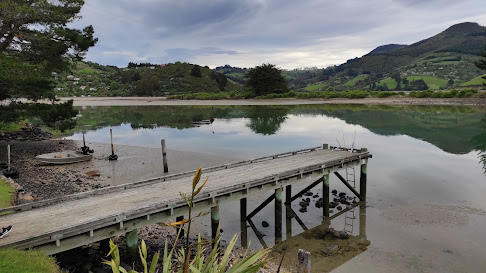
In other parts of the town, the road runs beside the tidal Waikouaiti River.  On a calm day, it is a very picturesque and peaceful place.

The views of the river mouth from this road was quite spectacular on such a calm day. 

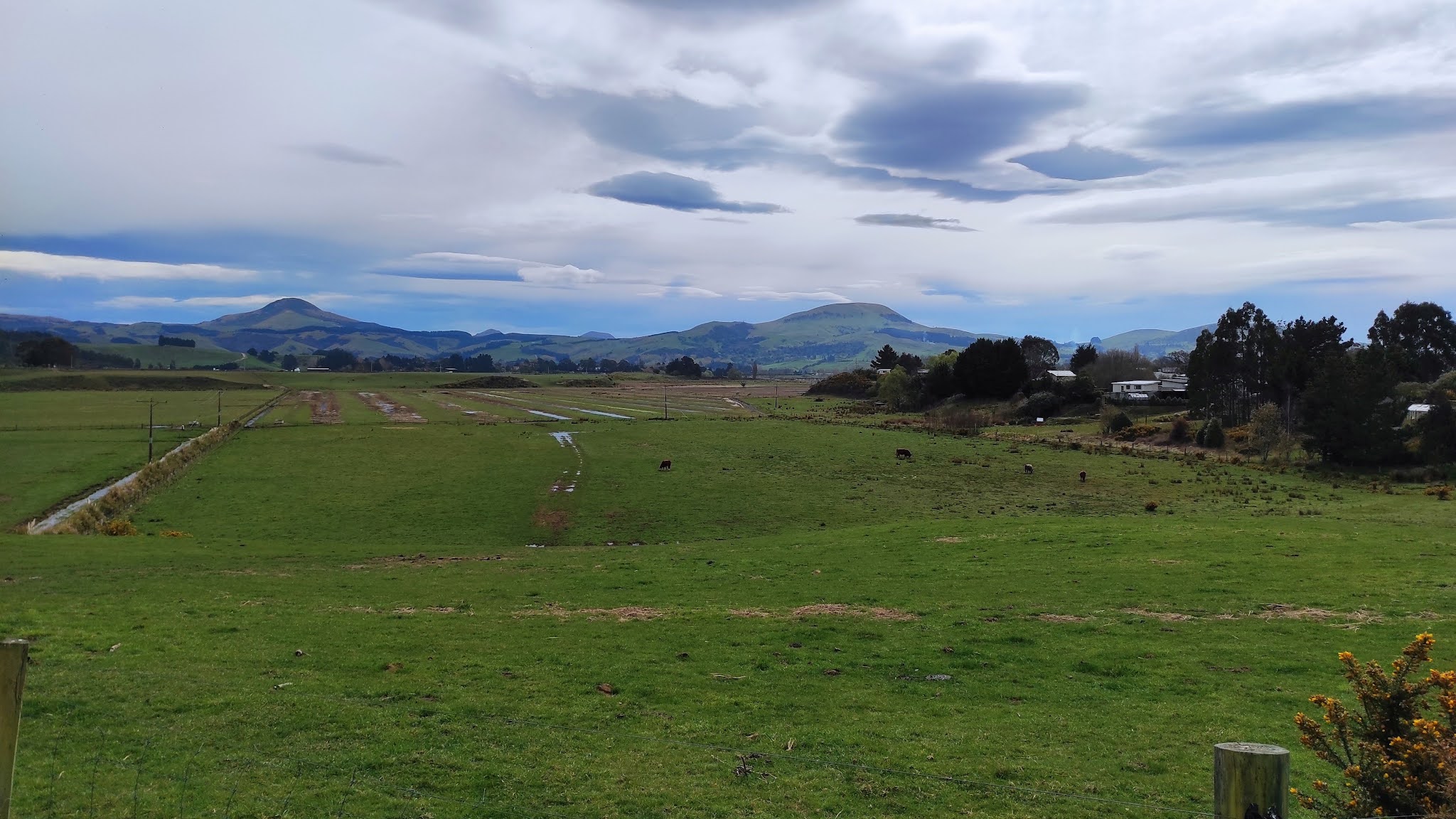
Not all the views were of the beach and river mouth.  Parts of the township looked over farmland with Mt. Watkin in the distance. 

Overall though, most of the houses in Karitane have views of the river mouth. The township is popular with day trippers from Dunedin City and it is easy to see why. 


On my walk today, I walked past these gates at Seacliff reserve which are a war memorial to the fallen soldiers of the Seacliff area. 

 Later in my walk, I walked past these gates in Karitane which are a war memorial to the fallen soldiers of Karitane.

 
At the entrance to Karitane is this cute whale welcoming people to the township.  This whale is everywhere as it has been made into street numbers for the houses. 
 
I saw some unusual sights during my walking today.  I came across this pile of old fishing pots at the end of a street. They look like they have been here for a while.
This boat looked like it wasn't going anywhere anytime soon.  It was almost like it had just been parked on the side of the road and forgotten about by it's owners.
And I don't known when this car was last driven but it's certainly been here for a long time.
This giraffe is very cleverly made out of old junk but it looks quite realistic. Whoever made it has put a lot of thought into it.
During my walk today, I walked past the Karitane public toilets that have wildlife found in the area painted on all sides.

 And lastly, I have included a map of Karitane with the streets that I have walked highlighted in red.


Distance walked:  11.9 km         Walking time  2 hr 12 mins  

Total distance: 740.8 km          Total walking  138 hr 48 mins 

Monday, September 20, 2021

Day Ninety Evansdale & Warrington

My plan was to walk the streets of the townships/suburbs north of Dunedin today and I walked four townships - Evansdale, Warrington, Seacliff and Karitane.  In this blog I will concentrate on the streets I walked in Evansdale and Warrington, and my next blog will cover the streets of Seacliff and Karitane.  I walked 18 streets.

1163. King Street
1164. Jones Road
1165. Bank Road
1166. View Street
1167. Bay Road
1168. Esplanade 
1169. Church Road
1170. Watson Street
1171. Ferguson Street
1172. Park Road
1173. Hill Road
1174. The Terrace
1175. Station Road
1176. The Crescent
1177. Stephenson Street
1178. Couper Street
1179. Perry Street
1180. Porteous Road
 
Today Evansdale was the first stop on my challenge to walk every street in Dunedin.  There is not much at Evansdale apart from farmland, two streets, a handful of houses and a hotel but Evansdale is part of Dunedin which means that I need to walk it's two streets.  One of the streets gives a good view of the State Highway One as it heads up the hill called the Kilmog.

From Evansdale, I moved onto walking the streets of Warrington.  Warrington is a small seaside township within the Dunedin City boundaries.  The streets seem to all lead towards the sea which is not surprising as Warrington has a lovely beach that is popular with families.

Warrington beach is a sandspit and on one side of the beach is Blueskin Bay. I was able to look across the bay to Waitati where I was walking streets yesterday.  Mt. Cargill is the hill in the middle of the picture in thedistance and the city of Dunedin is on the other side of Mt. Cargill.

By walking along the road towards the beach, I came to the Warrington Domain which sits behind the sand dunes of the beach and is a popular place for families during the summer. There is also freedom camping available at the domain. 

After leaving the domain, it was up a small hill which gave me good views of the beach. It is early spring and with the temperature still being a little cold, there was very few people on the beach today.

As I walked away from the beach I had views of the hills surrounding Warrington.  There is also a lot of new houses being built in Warrington. 

The railway line passes through Warrington with part of the township on either side.  It doesn't seem to matter where you live in Warrington as most houses seem to have a view of the sea or Blueskin Bay.
Known locally as the  'Flying Saucer house', this Futuro house was on display at the 1974 Commonwealth Games, it was then bought and moved to it's present site at the entrance to Warrington  in 1975.  Apparently there are 8 Futuro houses in New Zealand and this is the only one that I have seen.
Like the Flying Saucer house, this hedge is a bit of an icon in Warrington.   A loving husband trimmed the words 'I Love Lois' into his macrocarpa hedge in 2002 as a loving gesture to his wife. The tradition has been carried on to this day, nearly 20 years later.
I did not see any interesting letterboxes during my walk in Warrington or Evansdale today but I did see this unique birdhouse that has been carved out of a large tree stump using a chainsaw. 

 And lastly I have included a map of Warrington with the streets that I have walked in red. 

Distance walked:  5.9  km         Walking time  1 hr 2 mins  

Total distance: 728.9 km          Total walking  136 hr 36 mins 

Saturday, June 26, 2021

Day Sixty Eight South Dunedin

With threatening rain clouds,  I decided it was time to walk some of the streets on the flat of South Dunedin.  Today I walked 8 streets.

836. Turakina Street
837. Portsmouth Drive
838. Teviot Street
839. Otaki Street
840. Timaru Street
841. Colston Street
842. Andersons Bay Road
843. Midland Street
 
Part of my walk today took me along Andersons Bay Road which follows the shoreline of the harbour mouth before the land was reclaimed in the 1940's.  All the streets I walked today are on reclaimed land. This is a view looking along Andersons Bay Road, where the shoreline would have been prior to 1940.

I have skirted around parts of the harbour during my walks over recent months and today I walked along Portsmouth Drive which gives one of the best views of the city skyline and harbour.  On a calm day, it is a beautiful place to enjoy the view of Mt Cargill.

And looking the other way towards Waverley which is one of the first suburbs that I walked when I started this journey.  I walked this area back in January and it is good to know that I have walked all the streets that I can see from here.

I was quite excited to see this fur seal sunbathing on the edge of the harbour.  The seal doesn't look at all perturbed to be lying so close to a busy road, and it didn't mind getting it's photo taken. 
 
I walked along Portsmouth Drive which  was opened in 1978 after all the surrounding land was reclaimed.  Prior to the land being reclaimed, it was a causeway that ran along the edge of the harbour from 1912 and was used as access to the southern part of the city in the early days.  From the 1940's to the 1970's the land around here was reclaimed from  dredging the harbour.  The land is quite low lying and it is easy to see that there is no where for the water to go after heavy rain.


At the end of Portsmouth Drive, just before heading down the edge of the harbour is this large 3D map of the peninsula.  It is a great place to stop and see the topography of the peninsula and where the roads and walking tracks are. 

I found it to also be a good place to see how far I need to walk to get to the end of the peninsula.  This sign was also good for letting me know the distance I still need to walk. It looks like I have a 28km walk ahead of me to get to the end of the harbour.

Today I walked past two buildings with art on them.  This one is of a a couple of Tui and the forest.

The other is this penguin and the litter we leave in our wildlife's habitat.


Distance walked:  7.6  km         Walking time   1 hr 20 mins  
 
Total distance: 546 km       Total walking  102 hr 22 mins 

Otago Harbour Cycleway 30 October 2023

With my sister in town, it seemed a shame to waste a calm, sunny day so the two of us hopped on a bike each to enjoy the recently opened 32k...