Showing posts with label lagoon. Show all posts

Saturday, April 15, 2023

#45 of 100 trips for 100 years - Tomahawk Lagoon-Peg 41track 8 April 2023 (by Jade Pettinger)


Ten of us gathered at the clubrooms on Saturday afternoon for what was to be the first OTMC day trip during Easter weekend in at least 50 years. Heartened by the good numbers for a long weekend, we set out for Tomahawk Lagoon ready to conquer the Peg 41 track.
On arrival at Tomahawk Lagoon, we took a few minutes to admire the bird life before setting off. The beginning of the track winds its way through the bush on the edge of the lagoon before a sudden, steep climb out of the bush and into farm paddocks. As soon as we clambered over the rickety stile and emerged onto the expansive grassy paddocks, the views began to open up in front of us. The white sands and glistening blue ocean of Tomahawk and Smails Beach spread out in front of us.
Despite the cool wind, layers were soon being shed as the climb up the Peg 41 track was steady. We fell into a single file line as we skirted the edge of a paddock. This piece required some concentration as the paddock had an electric fence running up the side of it and all it would have taken was a slight misstep to end up electrocuted! Thankfully we were all careful and made it to the top unharmed.
Climbing over another stile, we had now joined onto the Soldiers Monument track that comes up from Highcliff Road. As we got closer to our destination, the wind seemed to increase. Once we arrived at the base of the monument, we soon found it was difficult to stand as the wind buffeted us. Some brave souls ventured up onto the monument, while the other more sensible ones found a perch out of the wind to have a snack.
Those of us who went up onto the monument had our breath taken away by the wind, and had to hang onto any loose clothing (even our glasses) as the wind threatened to take them away. It was a bit of a comedy show watching people try to walk around the monument as they struggled against the wind. The handrail was crushed in a death grip as it felt as if all it would take was one extra-strong gust and we would have been airborne. The view down the Otago Harbour was incredible, with not a cloud in the sky. Standing up there with the wind barrelling through your hair is certainly one way to feel alive.
It’s safe to say we didn’t hang around the top for too long - just long enough to devour some chocolate eggs (well it was Easter!) and take a quick team photo. Our intrepid leader decided that instead of walking back the same way, we would make the trip and loop and head down Centre Road. We headed down the steep track towards Highcliff Road, pleased to be leaving the wind behind as we dropped down below the summit.
It was single file again once we were on Highcliff Road to avoid becoming roadkill as we made the 500m or so journey to Centre Road. The road stretched out in a seemingly endless line in front of us, but as we chit chatted our way downhill we were surprised at how quickly the time went. We lamented that the best views were hidden behind trees or farm paddocks and were unable to be seen from the road.
Before we knew it we were rounding the corner back to Tomahawk Lagoon. We had made good time with a total trip time of around 2 hours, which no doubt would have been longer had the wind not been so strong. Although on the shorter side, it was a perfect way to spend a sunny Saturday afternoon.

by Jade Pettinger

Saturday, December 10, 2022

#14 of 100 trips for 100 years - Hawksbury Lagoon and Waikouaiti Beach 3 December 2022 (by Jade Pettinger)

What had started as a beautiful sunny Saturday morning had turned to some light rain as we 

headed to Woodhaugh Gardens for Trip 014, an impromptu Saturday afternoon trip to 

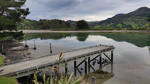
Hawksbury Lagoon and Waikouaiti Beach to make up for the cancelled Routeburn in a Day 

trip. As the clock ticked closer to 1pm, we were starting to think it would just be the three of 

us when Lindsay pulled up. We bundled into the car and headed north, our spirits lifting as 

the weather improved the further out of the city we got. 

Four of us quickly turned into six as just as we locked the car and were heading down the 

track Tina and Laurence turned up. We set off to Hawksbury Lagoon from Scotia Street 

North in Waikouaiti, crossing the unusual land bridge whilst happily chatting away. 

It soon became apparent that Hawksbury Lagoon was a bird watcher's paradise and we were kept thoroughly entertained as we wandered through the lagoon. There was an abundance of Black Swan/Kakīānau, and we were delighted to see some cygnets (baby swans) bobbing around the place. Other highlights included Royal Spoonbill and Plovers, the photographers in the group spent a great deal of time capturing the winning photo for the ‘Flora and Fauna’ category of the photo competition. 

Before long we arrived at the northern end of Waikouaiti Beach and were soon making 

good time along the beach. We were relieved at the lack of wind, which combined with 

the firm sand made for easy walking for the 4½km to the southern end of the beach. 

The next 45 minutes or so passed quickly as we walked along chatting. 

The sun had started to peek through by the time we reached the southern end of Waikouaiti 

Beach, opposite to Karitane. The crazy ones amongst us enjoyed some time paddling in 

the cold sea while the more sensible ones stayed firmly on dry land. Having stood at 

Karitane multiple times looking over the channel to the beach, it was really cool to be on 

the other side. While we were enjoying some jet planes (thanks Lindsay) we saw two 

figures approaching in the distance and soon were joined by Barry and Helen. 

With the thought of another long slog along the beach ahead of us, we decided to be 

adventurous and head back along the beach on the inlet side. This soon turned into quite 

the workout as the sand was incredibly soft and each step took immense effort. The rest 

of the group quickly learnt to follow in the footsteps of the first person which made their

 journey much easier - not so much for me in the front! 

Once it became apparent that the beach was running out and would no longer be a viable 

option, we went bush to try to find our way back to the main beach. Although we all started 

out following Antony, we somehow ended up going our own ways as we battled the head 

high grass. Thankfully we all made it safely to the beach and regrouped for the last few km 

back to the road. 

Having refueled on jet planes and with good company the walk back whizzed by and in no 

time we were at the road. A quick 1km or so up Beach Street to where we left the vehicles 

and we were soon headed back home. It was a really enjoyable Saturday afternoon trip to 

somewhere I hadn’t been before. We covered 11km in just under three hours, slowed down 

a bit by the soft sinky sand at the southern end of the beach but a great afternoon out 

nonetheless. 

written by Jade Pettinger 


Saturday, November 20, 2021

Day 115 Long Beach & Purakanui

While I haven't finished walking the streets in Port Chalmers yet, I headed over the hill from the port to walk the streets in the small suburbs of Long Beach and Purakanui.  I walked 12 streets today.

1549. Beach Road
1550. Mihiwaka Road
1551. Driver Street
1552. Baird Street
1553. Bay Road
1554. Watkins Street
1555. Mopanui Street
1556. Derdan Street
1557. Boundary Street
1558. Ridge Street
1559. Crescent Street
1560. Hill Street

Long Beach is a small coastal settlement within the Dunedin City boundary.  The beach, itself is 2.4km long and is a popular swimming beach as it is seldom affected by large swells or rips. The township of Long Beach is hemmed in between the beach and rocky bluffs or swampy farmland. 

There are around 100 houses in Long Beach with most being crib/holiday homes and the whole area has a lovely peaceful feel as it is one of the few areas that I have walked that doesn't seem to be growing with new houses. 


During my walk around the streets of Long Beach, I walked past the lagoon that is a popular place for children to canoe.  Today it is looking like it is full of water weeds but still very pretty. 

 
After walking the streets of Long Beach, I headed over the hill to walk the streets of Purakanui.  While Long Beach is flat walking, Purakanui is mostly hill walking with narrow and windy streets.

Purakanui is at the head of an inlet that is sheltered making it a good place to kayak.  The road goes down to the waters edge and on a calm day, it is a beautiful place to walk with fantastic views of the the inlet.
 
As I walked around the edge of the inlet, I was rewarded with great views looking towards Mopanui (the hill in the middle of this photo).  On the other side of Mopanui is the Orokonui Ecosanctuary.  The Ecosanctuary is a special piece of land that has been fenced off with a predator fence and has been turned into a giant aviary where the birds can fly in and fly out but while in the sanctuary they are protected and can breed.  

I really enjoyed my walk around the edge of the inlet as the views kept changing and around each turn gave me a chance to stop and see the hidden places that are not obvious at first glance.  This was a beautiful place to be. 
 
As I walked around the corner, I was able to see this historic 140 year old cottage right on the edge of the Purakanui inlet.  I was also able to see other steep streets that I would be walking. 

But before I reached those steeper streets, I had a great walk around the inlet where the views just kept getting better.

 
I couldn't resist taking photos as the view kept changing.  There are a number of boat sheds along the edge of the inlet making for a very picturesque walk. 

 
Eventually though, I had to leave the inlet and walk up the hill.  While the walking became harder, the views gave me a good reason to stop. 
 
While the houses are perched on the side of a hill, they all have amazing views. Some of the houses are quite far up the hill, while others are very close to the waters edge.

One of the streets that I walked down had this sign at the top.  It was quite an appropriate sign as the street was narrow and there was no where to turn a vehicle around.

This is the first time that I have seen this sign.  I didn't see any cats at all during my walk today but there must be at least one in the area.

 
During my challenge to walk every street in Dunedin, I have walked past many seats that are placed in some beautiful spots.

 
I walked past a couple of interesting letterboxes today.  I particularly liked the one with the garden growing on top of it. 

Distance walked:  7.3 km         Walking time  1 hr 22 mins    

Total distance: 949.6  km          Total walking  177 hr 08 mins 

Sunday, September 26, 2021

Day Ninety Three Waikouaiti

Since I had managed to only walk about a third of the streets in Waikouaiti yesterday, I returned today and walked another 13 streets.

1233. Court Street
1234. Malloch Street
1235. Park Street
1236. Pratt Street
1237. Mount Street
1238. Kildare Street
1239. Dame Street
1240. Geelong Street
1241. Collins Street
1242. Bourke Street
1243. Seddon Street
1244. McGregor Street
1245. Reid Street

I started walking the streets near the Waikouaiti School first.  These streets are on a small hill with views looking down to the Hawksbury Lagoon, where I had been walking yesterday.  The township of Waikouaiti has been built around the lagoon. 
 
Looking one way from the top of the small hill is the lagoon and the other is looking out over farmland.  Looking at the map, I believe the hill on the left is Pahatea Durden Hill and the hill on the right is Mt. Baldie. 
 
Just on the edge of the township is the Waikouaiti racecourse. Horse racing has been popular here since 1862 with the most popular races for many years being the New Years Day races, however that has been stopped and there is no longer any horse racing here.
 
The railway line runs beside the race course and divides the township of Waikouaiti in half.  This railway line is the part of the Main Trunk Line which runs the length of the country.  This part of the railway line was completed in the 1870's.
On the other side of the township is State Highway One.  This is the main road that also runs the length of the country.  This piece of road can be very busy but once you step onto the side streets, the township has a much quieter and peaceful feel to it.
 
I walked past the old Bank of New Zealand building.  The building was built in the 1870's and has been left untouched since it's last upgrade in 1927.  It is part of the Waikouaiti Coast Heritage Centre now and is open to the public.  The Cobb and Co. coach outside the Heritage Centre is a replica built by one of the Waikouaiti locals.  The Cobb and Co. stage coaches regularly traveled between the Waikouaiti and Dunedin
Further down the road from the old BNZ building is the old Post Office building.  Built in 1907, the Post Office not only had letters but also telegraph and morse code, and later a small manual telegraph exchange was installed. The Post Office was closed in 1989 and now the building has been turned into a home. 
I didn't see any unusual letterboxes today but I did see these minions made out of old car tires. 

 And lastly I have included the map of Waikouaiti with the streets I have walked highlighted in red.  This shows where the racecose is and how the township has been built around the lagoon.  I still have the streets on the right to walk.

Distance walked:  8 km         Walking time  1 hr 26 mins  

Total distance: 766.2 km          Total walking  143 hr 35 mins 

Saturday, September 25, 2021

Day Ninety Two Waikouaiti

The day was warm and sunny so I headed to Waikouaiti where I battled the wind to complete 15 streets today.

1218. Rockal Street
1219. Kilda Street
1220. Henry Street
1221. Jones Street
1222. Fell Street
1223. Thomas Street
1224. Scotia Street South
1225. Scotia Street West
1226. Scotia Street North
1227. Stewart Street
1228. Matanaka Drive East
1229. Matanaka Drive
1230. Beach Street
1231. Brown Street
1232. Anne Street

I realised that I had missed a couple of streets in Karitane last weekend so I went back to walk them today.  Kilda Street and Rockal Street border Huriawa Pa.  The Pa is a fortified Maori village from the late 18th century.  While there are no buildings at the Pa site, it is an historic site with walking trails throughout the area.  

The views from the road leading to Huriawa Pa climb a small hill which gives fantastic views along the coastline.  Once I had walked the two streets in Karitane, I drove to Waikouaiti where I began walking again.

Waikouaiti is a small township at the northern boundary of Dunedin.  Waikouaiti is a Maori name that means "braided streams" (Wai-koua-iti) or "small bitter waters" (Wai-kawa-iti). Waikouaiti is home to the first farm by European settlers in the Otago region in 1840.  Today, Waikouaiti is still surrounded by farmland. 

Once you walk off from the main road through Waikouaiti, the surrounding streets have a calm peaceful feel to them with very little traffic. 

However one of the downsides of walking the streets of Waikouaiti are the length of the streets.  The streets are in a grid formation with some of the streets being 2km in length.  I feel like I had done a lot of walking today but didn't complete many streets.

To avoid walking on the same roads, I took a 'shortcut' through the Hawksbury Lagoon.  The first settlers in to the area in 1840 drained parts of the lagoon to create farmland however in 1883 the community stopped further drainage and in 1912 the lagoon became a reserve. 

The lagoon is very large and home to a variety of birds and at different times of the year, large numbers of birds use the lagoon as a stopping place during their migration.  Today I only saw black swans. 
 
Once past the lagoon, I walked Beach Street which took me to the Waikouaiti Beach where the ship Magnet arrived with the first European settlers to the area. The beach, itself, is 4km long.  Thankfully I did not need to walk the length of the beach as the street goes only a small part of the distance.

And once I had reached the beach, I had to walk the long straight streets back to the main road.  The photo's don't show it but there was a strong wind today and I was walking into the wind along this street.  At times it felt like I was almost being blown backwards.

Waikouaiti is a town divided by the railway line with Scotia Street being on both sides of the line.  This is why there are three names for Scotia Street, depending on what side of the railway line you are walking.
 
I walked past this peaceful mini wetlands on the edge of Waikouaiti.  I could see pukeko and ducks in the wetlands and it was a beautiful place to stop and rest for a moment.

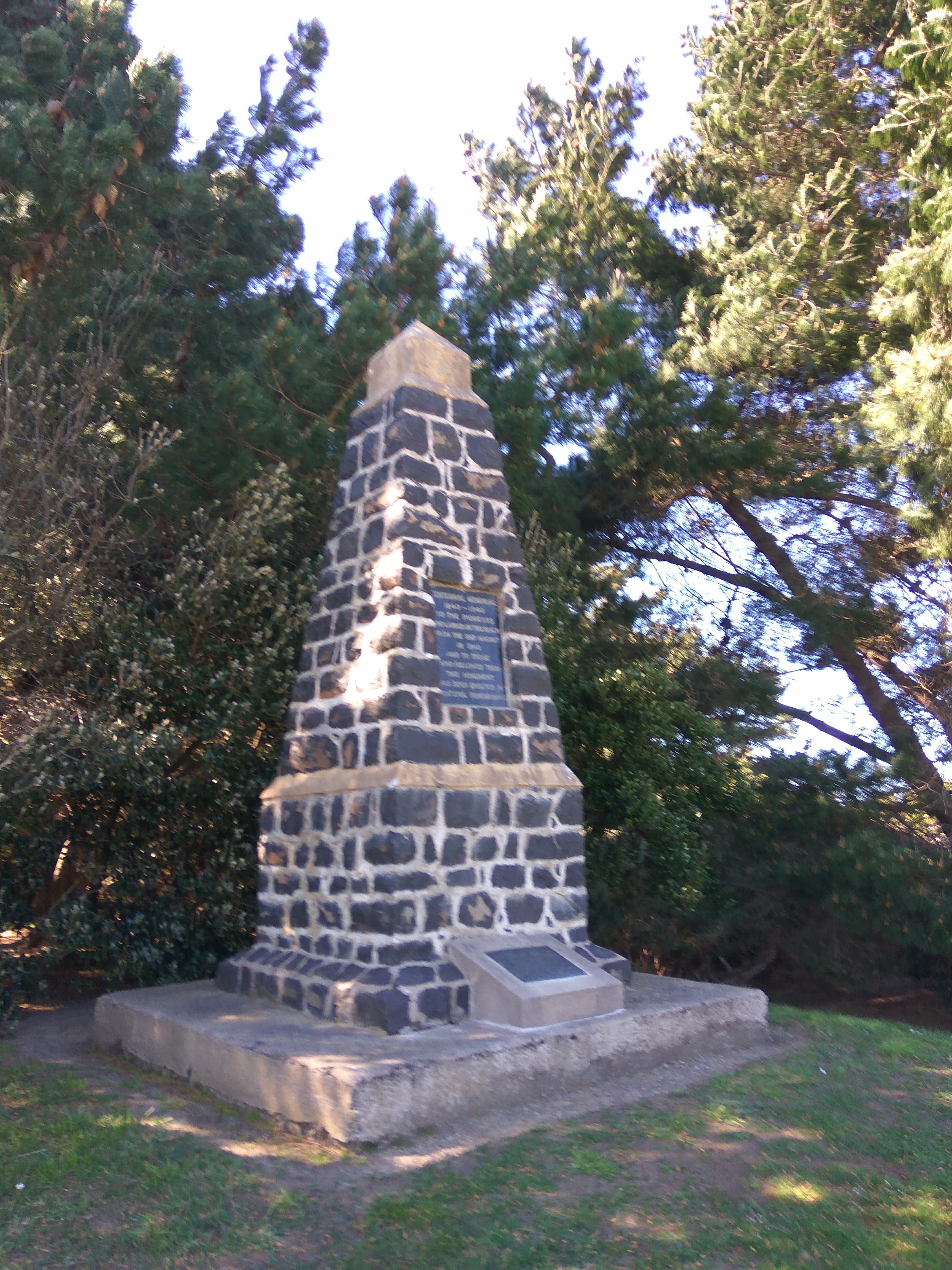
Near the beach, I walked past this monument which is honour the pioneers who arrived on the ship, Magnet, in 1840.

Waikouaiti has it's share of interesting letterboxes and these are some of the ones that I walked past today.  I particularly liked the bagpipe playing letterbox.


Distance walked:  12.9 km         Walking time  2hr 25 mins  

Total distance: 758.2 km          Total walking  142 hr 09 mins 

Otago Harbour Cycleway 30 October 2023

With my sister in town, it seemed a shame to waste a calm, sunny day so the two of us hopped on a bike each to enjoy the recently opened 32k...