Sunday, January 29, 2023

#27 of 100 trips for 100 years - Blackhead to Brighton via Green Island Beach 28 January 2023


Despite heavy rain further north, the day in Dunedin was warm and sunny with only a light breeze which was a good sign for a walk along Green Island Beach.  We arrived at Blackhead to a full carpark and waves crashing onto the sand making it easy to see why this is a popular surfing beach.  The cliffs of Blackhead are basalt columns similar to those we had seen at the Organ Pipes last weekend and the Pyramids two weekends ago.  The Blackhead headland of basalt columns juts out into the sea and there are some interesting rock formations that can accessed by scrambling around the base at very low tide.

Today, though, our mission was to walk along the beach from Blackhead to Brighton and with one and a half hours to low tide there was plenty of beach for the 9 of us to walk along.  The walk of 7km each way was very pleasant in the sun and with a tail wind on the journey to Brighton making for an enjoyable walk where  we saw a sea lion and only a handful of people walking their dogs.  The dogs looked to be having a lot of fun chasing balls and sticks in the water. We passed the Waldronville estuary without even noticing as there was no water flowing down the estuary. 
The further we walked down the beach the more sand was exposed by the retreating tide and there was plenty of opportunity to walk with different people which made the 1.5 hour walk to Brighton pass quickly.  
Once we reached the end of the beach, we found a large rock to sit and replenish the energy with a drink and some snacks in the sun while we contemplated the walk back.  We were all a bit jealous of Laurence and his cinnamon scroll but he wasn't keen to share so we contented ourselves with our own horde of lollies.
The second part of our journey was the return to Blackhead, however this time we had the wind in our faces.  This made for some lovely patterns in the blowing sand and with the tide out we looked to have a massive beach all to ourselves.  The bulk of Blackhead kept beckoning us on and before we knew it, we had passed the Waldronville estuary again and were back in amongst the dog walkers again. 
Once at Blackhead, it was a final scramble over the rocks and up to the cars.  The beautiful weather meant this had been an enjoyable 14km beach walk with great company. 

Tuesday, January 24, 2023

#26 of 100 trips for 100 years - Burns Track /Mountain Road (Track) / Rongomai / Evansdale Glen 22 January 2023


For one reason or another this trip is a repeat of #18 in December with the biggest difference being that the December trip had only three of us, this time the group was much larger with 10 people.  With memories of the mud still in my mind, we began with a walk of a kilometre or two along the Pipeline Track to the Burns Track turn off.  I was pleasantly surprised with how dry this part of track was and had high hopes that other parts of the track would be in a similar condition.  The start of the climb up the Burns Track is always steep and flattens out before a short steep climb to the Rustlers Ridge track junction which is where a compulsory morning tea stop was called. While most of us settled for water there was the one or two who broke out the thermos for a cup of tea.
From the junction we followed the contour around to Swampy Ridge.  The going was reasonably good with only the occasional muddy patch to contend with.  Being at the back was good because I could see where others had gone and could avoid the worst of it.  This is a pleasant part of the Burns Track as the bush thins with more open patches.  Once at Swampy Ridge we turned towards Hightop and this was the section where the mud had been at it's worst during our last time along here in December.  How different things can be a month later as the track is much drier and most of the mud had a thick porridge consistency rather than the ankle deep, wet, sloppy mud from last time making it much easier to avoid the majority of it. 
As we approached Hightop the bush opens out to golden tussock and with all the climbing and mud behind us we were able to relax and enjoy our surroundings more.  I have always enjoyed the tussock tops of the Silver Peaks and while most of the peaks are now covered in scrub, there are still some open tussock tops which are a pleasure to stroll through.  We made the small detour to the top of Hightop where we found a place to sit in the sun amongst the tussock for lunch.  
We had purposely chosen a place that faced West and we were rewarded with panoramic views of the Silver Peaks. In December the tops of the Silver Peaks had been obscured by cloud where as today we could easily see from Pulpit Rock all the way through to The Gap and beyond.  This was the route along Rocky Ridge that we had taken during trip #5 The Three Ridges in November.  One of the things I am enjoying as we complete the 100 trips is seeing how all the tracks and previous trips connect as we walk our through the them.  We could also see Hikarora/Mt Watkin near Waikouaiti which is where trip #36 will be going in March.
All too soon lunch was over and we were back on our feet and retracing our steps to the Hightop track where we were able to look down to our next part of our trip, walking along Mountain Road.  From this vantage point it is easy to see all the tree felling that has happened in the area and the contrast of the harvested pine plantation versus the lush green of the native manuka forest of the Silver Peaks Reserve. 
Finding our way down from Hightop involved some bush bashing as the track is indistinct in places but thanks to some good navigation with Antony in the lead, it wasn't long before we were back on track and rejoining the Green Ridge track which lead us to Mountain Road.  Here we stopped briefly for a team photo before starting the hot 6km walk along Mountain Road to the Rongamai track. 

The roadwalk is always monotonous and felt never ending however with good company the conversations were varied and the distance seemed to fall behind us with very little effort.  It is good with the pine trees gone to be able to see more of our surroundings and also to wonder about the trips the early club members did in the area, often running to Evansdale to catch the last train back to Dunedin. After an hour of road walking we reached the Rongamai track which starts as an old 4WD track before narrowing into a walking track and eventually onto a narrow ridge that then drops steeply to Carey's Creek.Itis here that care needs to be taken to avoid a fast descent, and with lots of trees to hang onto we were soon at the bottom without any mishaps.
The final stretch is a about 3km alongside Carey's Creek where last month had been a sea of lupins and today was more long grass and blackberries.  It is a pleasant walk beside the crystal clear creek and we were able to look behind at the ridge that the Rongamai track comes down.
Eventually we reached Evansdale Glen with the final hurdle being a shallow creek crossing which helped to wash the worst of the mud off our boots.  This had been a trip that covered 19.2km over a variety of terrain in around six and a half hours. 

Monday, January 23, 2023

#25 of 100 trips for 100 years - Bethunes Gully to Mt Cargill and Organ Pipes 21 January 2023

Kapukataumahaka/Mt Cargill has featured in over 150 OTMC trips with the first recorded club trip dating from 1924 so it seemed appropriated to have this as one of the 100 trips.  Despite the relative short distance traveled there is still a significant height gain of around 400m from Bethunes Gully to the top of Kapukataumahaka/Mt Cargill.  Maybe it is the prominence of Mt Cargill on the city skyline, maybe it was the warm, sunny day or maybe people felt like they needed a walk but whatever the reason, a good turnout of 12 people arrived at Bethunes Gully for the start of this shorter 100 trips day walk. 

The wide, gravel track starts from the carpark and follows Lindsay Creek for a short distance before crossing a bridge over the creek.  The track then begins to wind it's way up hill though pine plantation where there are a number of mountain bike trails through the pine trees, however we stuck to the main walking trail and continued past where David Bethune had built a brick kiln and sawmill in the 1870's.  There is very little to see today apart from a stand of large macrocarpa trees.  After leaving the pine plantation and moving into the native bush, we briefly stopped at the first view point of Kapukataumahaka/Mt Cargill.

From here the track continues to wind up through the native bush towards the top of Kapukataumahaka/Mt Cargill.  The track is wide enough for two people to walk side by side and everyone seemed to naturally break into groups of two or three chatting as we climbed higher.  Time and distance seemed to pass very quickly and we reached the junction to the organ pipes where we took the pathway that continued up to the top of Kapukataumahaka/Mt Cargill and the transmitter.  The views of the city, harbour and Blueskin Bay are always spectacular from the top. 
Surprisingly we saw very few people and just about everyone we did see was walking a dog.  This was also a good spot for a break and we took the time to replenish ourselves with a drink and a snack while taking in the city views. Often it can be windy on top of Kapukataumahaka/Mt Cargill but today was reasonably calm with only a slight breeze. 

The next part of our walk saw us returned down all the steps to the Organ Pipe track junction where we followed the track for only a short distance before turning off to climb Buttars Peak.  The city views from Buttars Peak are even more spectacular than those from top of Kapukataumahaka/Mt Cargill.  The rock formations on Buttars Peak are excellent examples of columnar jointed basalt and are easy to scramble over making it well worth a visit.  We had been here a few months earlier on trip #13 The complete Skyline Track.

 We crossed over the top of Buttars Peak and rejoined the Organ Pipes track for a short stroll across the ridge to the Organ Pipes where we took another break to enjoy the views and marvel at the 'pipes'.  No doubt the organ pipes would have been more spectacular during those early club trips, the columnar basalt tors are still an impressive sight. 
This was officially our turn around point and we retraced our steps back along the track to the Kapukataumahaka/Mt Cargill junction and down the main track back to Bethunes Gully.  The downward journey gave us a chance to mix and chat again, this time with different people to what we had walked up the hill with.  All up we walked around 10km in 4 hours. 

Tuesday, January 17, 2023

#24 of 100 trips for 100 years - Victory Beach and Pyramids 15 January 2023 (by Jade Pettinger)

17 of us assembled at the Clubrooms on Sunday morning, all of us keen to make the most of another beautiful summer day and explore Victory Beach. We quickly sorted ourselves into cars and headed down the harbour towards Portobello, admiring the stunning views our city has to offer. Before long we had arrived at our destination! Piling out of the cars we applied sunblock, donned sunhats and tied shoelaces ready to go.
It was just over a kilometre from the carpark to the pyramids, traversing some paddocks on a 4wd track. The track was flat and in a straight line and would have made for a dull walk if it were not for the delightful company. Arriving at the pyramids, it was time for a team photo before heading off to explore the cave at the bottom of the small pyramid. The cave was interesting as we could see clear examples of columnar basalt, the same type of rock as the Organ Pipes.
After consulting with our leader Alan, it was decided that we would take the scenic way to the beach. The loop around the reserve is a bit of a self-guided tour, with numbered markers along the way which tell you some information about the area. We enjoyed learning some facts and observing the work that has been done by the Yellow Eyed Penguin Trust to create a safe habitat for these endangered wildlife. A highlight was seeing some trees that Jade had helped plant at school in 2004, nearly 20 years ago!
After close to an hour of exploring the reserve underneath the beating hot sun, we arrived at the edge of the sand dunes. Making our way down to Victory Beach, we were delighted to see we had the beach to ourselves (minus a few sea lions). The beach was absolutely stunning - crystal clear water that sparkled in the sun and a wide expanse of white sand as far as the eye could see. Some of us took the opportunity to shed our shoes and feel the cool water swirling over our toes, providing some much needed refreshment.
We began our trek to the south end of the beach, keeping our distance from the sea lions dotted around the shoreline sunbathing. One sea lion was a bit curious and came over to see what we were up to, forcing us to make a hasty retreat before he settled down again and we could continue on our mission.
Near the south end of the beach we spotted the remains of the SS Victory, which ran aground in 1861, en route from Port Chalmers to Melbourne. Fortunately no lives were lost due to the proximity of the beach, however as the ship was embedded in 6-7 feet of sand it was unable to be salvaged and thus became the namesake of Victory Beach.
Rounding the end of the beach we reached Papanui Inlet and were pleased to find a sheltered spot out of the wind for lunch. Just as we were settling in, an inquisitive sea lion was spotted playing in the calm waters of the inlet before popping up to have a look at us. Upon deciding we weren’t a threat, the sea lion plopped back in the water and continued his play time - not a bad idea on such a hot day!
Lunch was quickly consumed before we packed up and made our way alongside the inlet, keeping a careful eye on the playful sea lion in case he decided to make another appearance. All was well and we plugged our way through ankle deep sand, admiring the expansive views of Papanui Inlet, Mt. Charles, Harbour Cone and even all the way across the city to Mt. Cargill.
We soon arrived at a farm track, relieved to be trading in the soft sand and the relentless sun for firm ground and some shade provided by the trees. The track was dotted with sheep huddling under any shade they could find. Arriving at the road, we geared ourselves up for the final kilometre or so along the dusty gravel road back to the cars. 

by Jade Pettinger

Wednesday, January 11, 2023

#22 of 100 trips for 100 years - Kaikorai to Whare Flat and return 8 January 2023

In an attempt to find out what it was like for members of the OTC one hundred years ago we decided to walk from Cableways in Kaikorai Valley to Whare Flat and return.  This route would have been one that those early club members did often as Cableways is the end of the cable car line and this would have been their starting place to access tramping areas.  Expecting this trip to be a longer day with no water enroute and a warm, sunny day we didn't expect a large crowd so were pleasantly surprised to have 7 people meet at Cableways.  The first part of the trip was a 300m climb up Taieri Road and along Whare Flat Road.  Being mostly on the sealed footpath, we were able to chat with others during the climb up the hill which seemed to take no time.  Before I knew it, we were at the forestry gates in under an hour.
The early OTC members followed tracks through what is now forestry but would have been native bush down to Whare Flat and that was our intention today.  After entering the forest from the locked gate we took the first right off Laing Road onto a mountain bike trail that took us on an easy 1.9km wander through the pine forest to the Bull Ring.  From the Bull Ring we again took the first right onto  another mountain bike trail which was heading down the hill in the general direction that we wanted to go.  Because the trails are for mountain bikes they were easy to follow and whenever we reached a junction we kept taking the trail that continued to take us down hill until we reached one of the main forestry roads which we followed to Whare Flat.
Once at the locked gate of the forestry roads at Whare Flat we opted to follow the gravel road and over the ford where one of our OTMC drowned during the club marathon 15 years ago.  We stopped for a couple of minutes to remember Trevor before carrying onto the Whare Flat School which was a regular stopping place for 'a brew up' by the early club members 100 years ago.  The school was opened in 1868 and once hosted up to 42 children from all over the Taieri before closing in 1948.  While looking a little overgrown the school building still stands behind it's school gates looking to be in reasonably good condition for having been unused for almost 75 years.
We continued down the Whare Flat Road to the Silver Stream car park which is where there was some discussion about lunch but upon deciding it was a little early we continued through the ford and over the bridge before heading straight up to the Tunnels Track.  The Tunnels Track is a nice meander beside the water race.  Built in the 1870's the water race provided much of the water for a reservoir in Kaikorai Valley for the growing city of Dunedin until the 1960's when it was deemed there were too many problems with subsidence and the weir was no longer maintained.  We passed one of the two tunnels on the water race where one of our team who was happy to get his feet wet, jumped in with a head torch to see how far the tunnel went.  Not being able to see the end it wasn't long before he was back out into the sunshine.

As the water race follows the contour of the hill it is easy walking until the pine plantation is reached then it is a short scramble up out of the bush.  It was here that we elected to have lunch in the shade of the trees.  After lunch we were back onto the forestry roads heading up the hill to Flagstaff.  This time we opted to take Longridge Road which we nicknamed 'the long easy' because it was a constant easy gradient winding it's way up the hill.  We were rewarded for our efforts half way up the hill where the pine trees had been harvested and we had great views of Whare Flat, Taieri Plains and Saddle Hill. 

By now the temperature was rising and it was hot work up the hill on 'the long easy' which felt like it just kept going - and it did for 5km until we reached a junction and could take Laing Road back to the forestry gates where we had entered the forest this morning.  Thankfully Laing Road mostly follows the contour so we were granted a rest from the uphill.  Once at the locked forestry gate we retraced our steps down Whare Flat Road and onto Taieri Road where we were surprised to find an armchair on the footpath. Not wanting to waste an opportunity, one of our team was quick to take a rest before walking further down Taieri Road where we took a compulsory stop at the ice cream shop.  Once replenished with an ice cream it was a fast final 1km to the cars.  

A great effort of 7 hours 45 minutes for the round trip of 30km.  We were left to wonder about those early OTC members who would walk what we had just done just to get to the start of the tramping area and then  go onto to do their tramping trip often returning by candle light.  Our conclusion was that they must have been very fit!

Tuesday, January 10, 2023

#20 of 100 trips - Campbells Road/Bethunes Gully/Watts Road 7 January 2023 (by Jade Pettinger)

After our first attempt at this trip in December last year was postponed due to inclement weather, we had our fingers and toes crossed that the 7th of January would be kinder to us. Heading into the first week of 2023 we had fantastic weather - days on end filled with blue skies and warm temperatures, until… the day before the trip, thunderstorms rumbled across the city, pelting us with heavy rain and once again we thought the trip would be rained off. Waking up on the 7th we anxiously peered out the window and were pleasantly surprised to see the weather had cleared, the trip was on! 

This was a special trip for us as it was in our ‘backyard’, the meeting point was a 2 minute walk down the road at the intersection of Campbells and Pine Hill Road. We meandered down the road and, despite being 20 minutes early, were delighted to see people were already starting to arrive. By the time the trip was ready to depart at 11am, a staggering 22 people had gathered, perhaps an OTMC record for a day trip in early January?


It was a speedy trip up the hill to the end of the paved part of Campbells Road, with groups happily chatting away and catching up on what everyone has been up to over the break. Layers were soon being stripped off as the weather was warmer than expected after yesterday's downpour. One local must have been amazed to see such a tribe walking up the ‘dead end’ road and stopped to find out what we were up to.

With warnings of a bull that was supposedly roaming the paddocks we intended to cross ringing in our ears, we bravely opened the gate and entered the paddock anyway. While this section of the track appeared to be traversing a farmers paddock, we were actually on a Paper Road. These are unformed roads, often on what appears to be private property, however are recognised as legal roads and members of the public have the right to access these without having to gain permission from landowners. We followed the Paper Road (an extension of the formed Campbells Road) through the paddocks, on high alert for any possible sightings of a rogue bull, although to our relief the only livestock we found evidence of were sheep

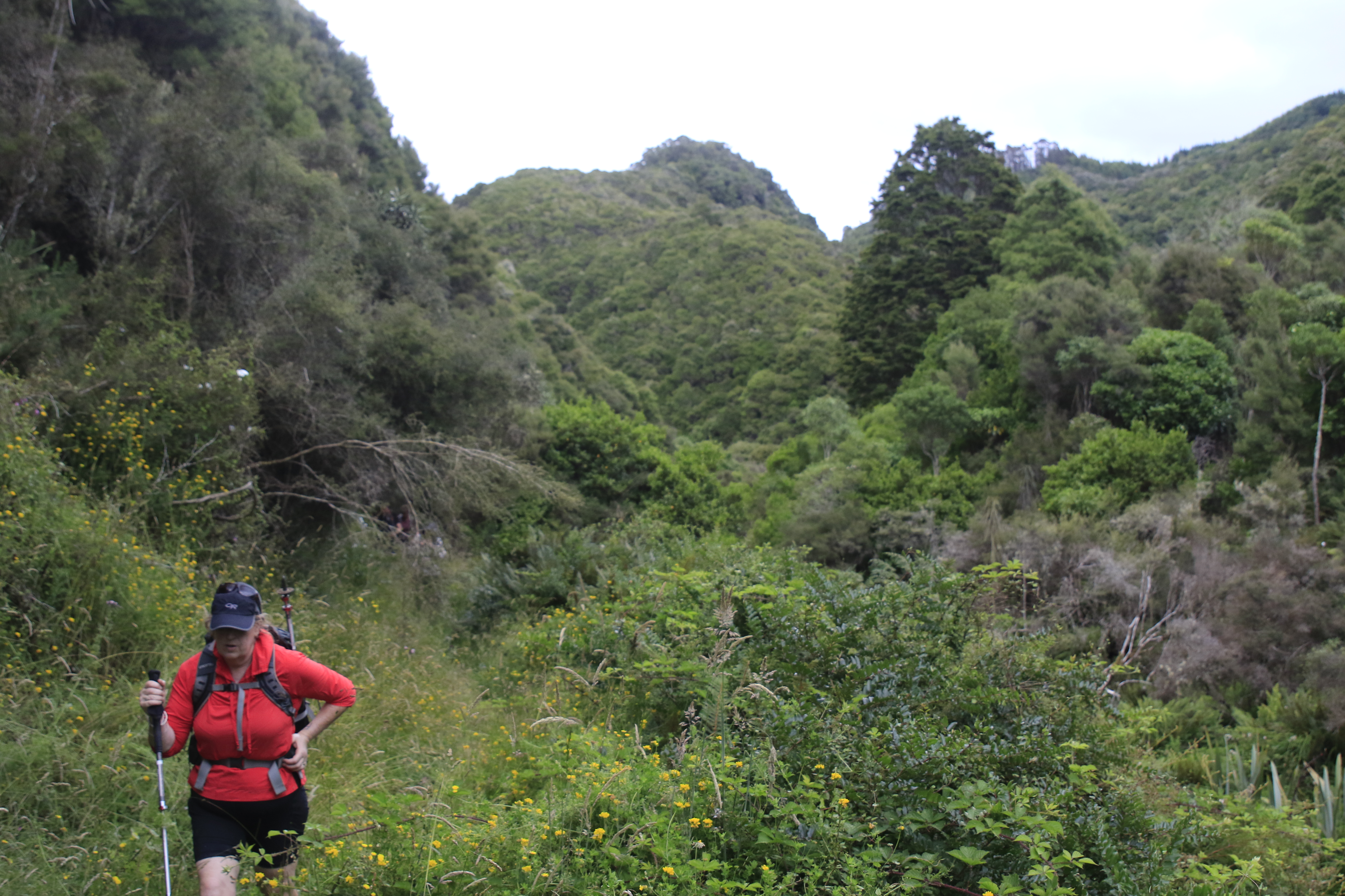
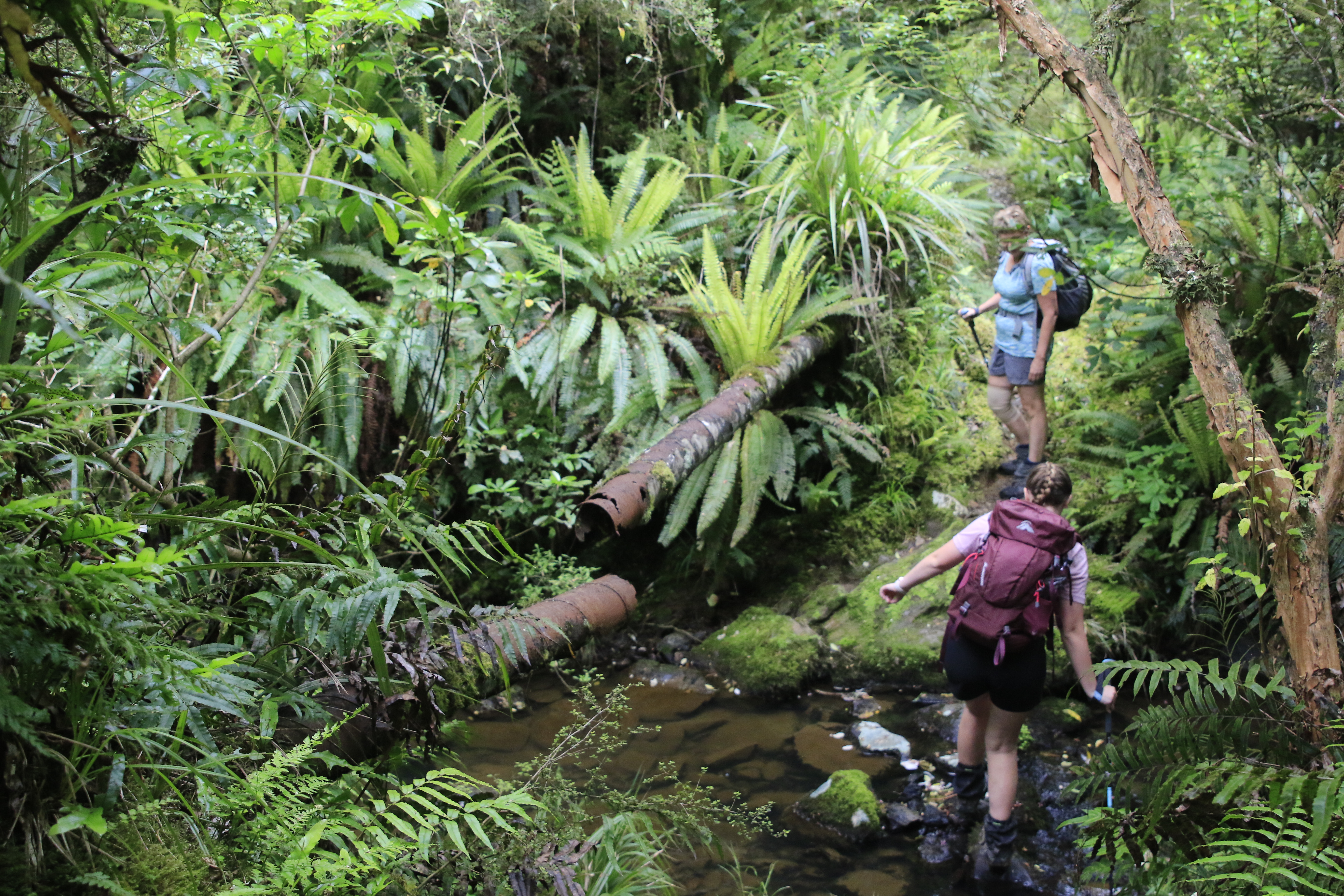
After dodging the muddy bogs of the paddock we arrived at the bush which marked the beginning of the Mount Cargill Scenic Reserve. This section of track was certainly more interesting, however the slippery mud made for slow going. A few of us took a tumble, although thankfully the only wounds were to people's dignities. Being a section of bush that is not commonly visited, we were able to appreciate the true beauty of New Zealand bush. It was so vibrant and lush with rays of sunlight peeking through the thick bush, highlighting the endless shades of green which makes the NZ bush so magical.

Before long we arrived at the junction of the Bethunes Gully - Mount Cargill track and with our tummies starting to rumble for lunch, we set off at a brisk pace down the well-maintained track towards Bethunes Gully. The scenery soon started to change as we made our way through the pine forest and eventually to the open fields of Bethunes Gully. Lunch was quickly consumed, the obligatory team photo taken and packs were back on for the final ascent back up to Pine Hill.
The weather was really starting to heat up as we headed along North Road, happily chatting away in small groups. A quick pit stop was made to rehydrate before the slog up Watts Road. The section walking up the road was steeper than expected, and the speedy pace we had maintained for the rest of the trip was soon replaced as we plodded up the hill. We gained height quickly and by the time we reached the end of the tarseal we had quite a good view down into North East Valley and across to Ōpoho.
The end of the tarseal marked the beginning of another Paper Road, straight up the paddock to join up with Abbeyhill Road in Pine Hill. After negotiating our way up a scrambly bank and over a couple of fences, we were met by some power poles which indicated we were not far from our destination. Sticking to the fence line, it was a straightforward climb up the hill, although thankfully the gradient was not as steep as it had been on the road. We stopped to admire a set of old rugby posts, dreaming of days gone by when games would have been played perched on the side of the hill.
Before we knew it, we were clambering over the stile and onto Abbeyhill Road. A quick head count and it was soon confirmed that all 22 of us had made it safely back up the hill. While the majority of the group made its way back down the hill to the starting point, we said our goodbyes at the end of our street and headed home for a well-deserved cold drink.

Trip #20 ticked off the 100 Trips list, and what a fantastic trip in our backyard it was. The OTC used Campbells Road to access Bethunes Gully in the 1930’s, and it was great to put our own spin on this to create a loop trip in an area not usually frequented by the club but certainly well worth the visit. In total we were away for about 3 ½ hours (including lunch) and walked about 8km. 

Written by Jade Pettinger

Friday, January 6, 2023

Black Gully to Evansdale 4 January 2022 (was #3 of 100 trips)


Following Careys Creek from Black Gully to Evansdale was trip #3 of 100 trips in October 2022 and as I had missed the trip (we were on weekend trip #2 of 100 trips) Three of us decided it was time to walk this track that I'd not completed before.  Starting at Double Hill the track initially winds its way through a tunnel of flowering manuka before dropping a knee jarring 100m downhill to Black Gully. The descent is made slightly easier with a number of steps cut into the bank making for a fast descent over a reasonably short distance.  We made the small detour to Black Gully Dam which was built in 1912 along with 17 km of pipeline to give water to the Seacliff Mental Hospital.  The flow to the hospital was gravity fed and not always successful due to the distance and terrain the pipe traversed.  After a fire at the Seacliff Hospital in 1942 with the loss of 37 lives, it was decided that a more reliable form of water supply was needed.

From the dam the track follows the old pipeline, crossing the stream often.  It is easy to see how difficult the terrain  made it to install and maintain the pipeline around 100 years ago.  There are numerous places that the pipeline is broken and these made the walk along the track more interesting.
The first part of the track is very pleasant walking between the moss and ferns beside Careys Creek.  The creek winds its way around slippery rocks and through numerous deep pools that look perfect for a dip in the clear water.  At this time of the year, the Careys Creek track is good for mushroom enthusiasts with a large variety of fungi to see. Not knowing the names of the mushrooms we saw, all I can say is that we saw  small perfectly round marble sized red fungi, large red and white spotted ones, grey frilly ones, large cream coloured ones and round white doughnut shaped ones.  We passed a number of fallen logs spouting whole cities of fungi.

As the track continues down the valley, the track moves from native bush to open grassy meadows and back into the bush with numerous stream crossings interspersed with the odd patch of pine forest.  After the lush greens of the native bush and bright sunshine of the grassy meadows the pine forest is dark and ominous.  It was good to pass through the pine forest quickly and back into the sunshine again.

From about half way the track drops into the creek and continues along the creek bed, crossing from one side to the other.  Keeping dry feet became impossible and it was refreshing as the water filled our boots and helped to cool us down. The track would climb out of the creek bed for a short distance then drop back in again.
 
There were patches of mud to negotiate, however the numerous creek crossings were good to wash the mud off.  In places the pipeline would disappear while in other parts we needed to continually step over it.  The pipeline often sat on top of the rocky ground like a snake, closely following the creek bed while other times it was raised above the ground.    All the time we continued to follow it down the valley.

Once we reached where the Honeycomb track joined the Careys Creek track the going became easier with less creek crossings and less mud.  We stopped for lunch beside the creek.  While enjoying the coolnes of sitting near the creek on a hot day we saw a couple of freshwater lobsters moving about in the clear water.  It is surprising how small the cracks and holes the lobster can disappear into under the water. Feeling replenished from lunch we continued down the track, in and out of the water for another hour until we reached Evansdale.  All up the trip was around 10km and took 4 hours (including stops). 

Otago Harbour Cycleway 30 October 2023

With my sister in town, it seemed a shame to waste a calm, sunny day so the two of us hopped on a bike each to enjoy the recently opened 32k...