Showing posts with label Dunedin botanic gardens. Show all posts

Sunday, December 18, 2022

#19 of 100 trips - Gardens / Upper Junction / Blanket Bay / return to Dunedin Gardens 17 December 2022

Five intrepid trampers met at the Gardens corner to recreate one of the early tramping trips of the Otago Tramping Club which involved a lot of road walking which, for the early trampers, would have been on narrow, winding gravel roads but for us was on mostly narrow, winding sealed roads and a wide, flat, smooth cycleway.   We were quietly confident that the sea fog would lift by the time we had reached Upper Junction so that we would be able to see the views, little did we realise how wrong we were.  Meeting at the Gardens corner we set off walking up North Road towards Upper Junction.
The first two and a half kilometers has only a mild gradient and the time went quickly as we walked and chatted our way up North East Valley.  Once we reached Normanby the gradient increased and the sea fog seemed to come lower down the hill so that it felt like it wouldn't be long before we walked into it.  It was a nice surprise to meet my father out for his morning walk and we stopped for a brief chat before continuing on.  Only a short distance on the footpath ran out and we were walking along the edge of the road. 
One of the reasons for the early start to the walk was to avoid the traffic on this part of the road and for the most part it worked with only spasmodic traffic. The higher we climbed the thicker the fog became and by keeping well to the side of the road, we didn't disrupt any traffic.  One of the good things about road walking is that the slower pace means that you get time to see things that you'd normally miss when driving past which is exactly what we did - chatting to passing cyclists, listening to the birds, spying bugs in the long grass, watching the sheep and cows (who were watching us), admiring the flowers and our most unusual find was one new, unused boot. 
The higher we climbed the thicker the fog/mist became so that when we reached the highest point at Upper Junction, disappointingly there was no view.  Instead of admiring the view of North East Valley and the city that was hidden to us, we took a small detour to visit the war memorial on the site of the former Upper Junction School that was destroyed by fire in 1945.  There are 17 beech trees planted beside plaques in remembrance of former pupils who were killed during the first world war. This is a particularly poignant war memorial for me as my fathers uncle has a plaque and beech tree planted in his memory here.  John Williams was 17 when he signed up, lying about his age so that he would be accepted into the army and killed at the Somme, aged just 19 years.  It seemed very fitting with the muted light from the  mist swirling around the hundred year old giant macrocarpa trees creating an ethereal atmosphere during our visit of this site.
What goes up must then come down and that is exactly what we did, heading 300 metres down hill on Upper Junction Road, all the way to sea level.  It seemed almost impossible but the mist seemed to grow thicker and we were barely able to see each other at times.  The striking views were non-existent so had to keep an ear open for cars to avoid being hit on the narrow, winding road.
As we dropped lower the mist slowly started to thin until we dropped below it and finally got our first views of the surrounding farmland and down to the harbour. We stopped on a sweeping bend where we could get well off the road for a morning tea break.  Replenishing ourselves with a drink and snack while admiring all that we could see.  With the hills on the opposite side of the harbour and most of the city being shrouded in fog, we were only able to see down to Blanket Bay and Roseneath. 
Knowing that most of the hill was behind us, we continued down the hill where we eventually met up with the main road to Port Chalmers, State Highway 88.  We admired the yet to be completed new cycleway/walkway including the blue surface from a distance. Despite the cycleway looks like it is completed, there are large fences stopping access  so we continued walking along St Leonards Drive.
A lunch stop was called at St Leonards Park where Mandy found a swing to sit while the rest of us opted for the picnic table.  Lindsay arrived with his dog and a box of cherries which he shared while we watched a large ship sail past on it's way to the inner harbour.  By now we were over halfway through our walk and were about to start on the 'easy' part of our walk, along the flat cycle/walkway which runs beside the railway line.  This proved to be more difficult than first thought as the 8km of flat, hard surface made for tired legs and feet.  The fog was lifting with the views of the harbour opening out and we were able to distract each other by seeing who could spot the most interesting sight.  Some of the interesting things we saw were kayakers getting tooted at by the harbour tug for being in the main shipping channel, swimmers jumping off the harbour channel markers, a speedboat jumping the tug boats wake, a grey spoonbill, a few sad, rotting boats, some exercise equipment, lots of walkers and only a handful of cyclists but no trains. 
Once we reached the stadium we turned off the cycle/walkway and continued past the University, skirted around a cricket match in progress and wandered through the student housing until we reached the Water of Leith. We followed the Water of Leith through the Gardens and back to the main gates where we had started 5.5 hours and 21km earlier.

Saturday, August 21, 2021

Day Eighty Liberton

I enjoyed my walk in the sunshine around the streets close to home today.  I walked 20 streets

986. Raleigh Street
987. Hillary Street 
988. Dover Street
989. Lowe Street
990. Tasman Street
991. Tensing Street
992. Egmont Street
993. Allenby Avenue
994. Blundell Street
995. Hislop Street
996. Wilkinson Street
997. Truby King Crescent
998. Pryde Street
999. Croydon Street
1000. Barclay Street
1001. Buccleugh Street
1002. Glencairn Street
1003. Gladstone Road
1004. Forrester Avenue
1005. Newhaven Street
 
 It was a frosty start to the morning and I walked gingerly around the streets that were still in the shade.The first group of streets I walked around are all named after mountains and climbers.  Hillary Street and Tensing Street being the most obvious along with Lowe Street for climbing Mount Everest. Tasman and Egmont are New Zealand mountains and Dover is a mountain in Antarctica.
Many of the streets in Liberton have great views.  Some of the streets have good views of Flagstaff and look towards where I was walking yesterday.
Streets on the other side of the hill have great views looking towards the city.  After stopping to admire the view, I walked down the hill to then walk back up to where I started.
The further down the hill I walked, the views changed to looking towards Opoho and North East Valley.  The road also became very narrow as it grew steeper the nearer I got to the bottom.

The residents of these houses have very steep sections/gardens and very little parking but the views they get are outstanding. These are streets that I have not walked yet.

Of course what goes down must also go up and some of the up was quite steep but as I walked up the hill, I was reward with more great views.   This is looking towards Opoho and are streets that I have not walked yet.

The higher I walked up the hill, the views changed and I was able see over to the Dunedin Botanical Gardens with a glimpse of the harbour and Waverley beyond.

And as I neared the crest of the hill, the view changed back to Flagstaff.  The weather is beautiful and the views have been fantastic today. 

I stopped to have a look at the Dalmore Reserve which has been turned into a community vegetable garden.  The garden is a little overgrown after the winter but it does have great views of the city.
One of the more sad things that I have walked past during my challenge of walking every street in Dunedin is this wooden seat which has a fantastic view of the city.  The seat is dedicated to baby Mae. 
Today I walked past three interesting letterboxes.  One is an ordinary letterbox that is painted like a house while another has used a large piece of interesting wood to cleverly create a letterbox and the third letterbox has been decorated with mosaic tiles.


The ultimate in recycling is this used chain to make the house number on the fence.

The Pine Hill bus stop has been beautifully painted with scenes of the early Pine Hill School. The scenes are taken from old photographs of the school and have been faithfully replicated in the bus stop.


Distance walked:  11.2  km         Walking time  2 hr 10 mins  
 
Total distance: 653.0 km        Total walking  121 hr 52 mins 

Friday, April 16, 2021

Day Fifty Seven North Dunedin

As the nights get darker earlier, I am walking streets closer to home and today I walked part of quite a few streets but only completed 6 streets

706. Titan Street
707. Gore Place
708. Lovelock Avenue
709. Arden Street
710. Sylvan Street
711. Knox Street

I walked around part of the student area which is mainly on the flat so there weren't many views.  One place that I got a great view was at the look out near the Northern Cemetery down to the playing fields near the University and out to the harbour.

I also saw Mount Cargill as the sunset and the clouds turned pink.  I have enjoyed looking out for Mount Cargill as I walk around the city.  As long as you can see Mount Cargill, you will never get lost in Dunedin.

On my walk today I walked past the Willowbank Distillery.   The Willowbank Distillery was opened.  and was the world's southern most distillery and it thrived until 1997 when the factory was sold and closed. The remaining barrels of whiskey were auctioned and are currently being stored in Oamaru.  Today the stone distillery buildings have been converted into student flats. 

On a narrow street hidden among the student flats is the Robert Law Writers Cottage.  The cottage, once owned by writer Robert Law who died in 1992, is run by a trust.  The house is available for writers to come and live in Dunedin  for a limited time rent free so they can concentrate on their writing.


Nicknamed 'the Coronation Street flats' because they look very much like the terraced houses on the British TV show Coronation Street, these flats and many others like them have housed students for many years. 

My walk tonight took me past many of the older Coronation Street type houses.  Parking is at a premium in the student housing area. 


I enjoyed walking Lovelock Avenue which runs through the Dunedin Botanic Gardens.  Lovelock Avenue is named after Jack Lovelock who  was New Zealand's first gold medalist in to win a gold medal in Athletics in the 1936 Berlin Olympic Games.  

Lovelock Avenue winds it's way from the University to Opoho through the upper gardens so the gardens is on both sides of the road. 

On Lovelock Avenue is Lovelock House which was built in 1876 as the residence for the supreme court judge. The house consists of 14 bedrooms and is now used as student accommodation

I have been able to see the Dunedin Botanic Gardens during many of my walks and today I walked right around it.  The Dunedin Botanic Gardens is the oldest botanic gardens in New Zealand, established in 1863 and is the end of the Dunedin town belt.  

 At the entrance to the Northern Cemetery on Lovelock Avenue is the memorial to Thomas Bracken. Thomas Bracken  is an Irish born New Zealand poet who wrote the New Zealand national anthem 'God Defend New Zealand' in 1878.  He is buried in the Northern Cemetery. 

At the lookout near the Northern Cemetery I walked past some huge Australian Gum Trees.  I imagine they were planted around the same time that the cemetery opened in 1872.

I walked past one painted telephone cabinet tonight.  It reminds me of a more psychedelic time. 


Distance walked:  6.1 km      Walking time   1 hr 6 mins    

Total distance: 450.8 km       Total walking  84 hr 46 mins

Saturday, March 6, 2021

Day Thirty Seven Maori Hil

It was an interesting walk today where I walked some wide streets and also some very narrow streets.  Today I walked 12 streets.

474. Cosy Dell Road
475. Kyle Street
476. Ailsa Street
477. Lachlan Avenue
478. Highgate
479. Henry Street
480. Falkland Street
481. Lothian Street
482. Pollock Street
483. Como Street
484. Viewpark Lane
485. Chamberlain Street

I made a slight error in judgement today because I first walked down one of the paths through the town belt as I intended to start further down the hill.  Unfortunately the path I took didn't take me to the street that I thought I was going to start on and instead I ended up being further away than I had planned.  Not that it was much of a problem because I just kept walking until I got to where I was supposed to be and it also meant that I walked a few 'extra' streets.  

One of those extra streets was Kyle Street which was unusual as it was a narrow street through a tunnel of trees. I had no idea where it was taking me.  At the other end of this street was a tennis court and a few houses.  I did wonder why Kyle Street needed yellow no stopping lines as it is clearly not wide enough for anyone to park in. 

My earlier mistake through the town belt meant that I was on the outskirts of the University student flatting area and it was very obvious the difference in the state of the streets to anywhere in the city that I had already walked.  It is a shame that students seem to think that it is OK to just walk away from their rubbish. 


From Lachlan Avenue and Ailsa Street there are good views of the Dunedin Botanic Gardens which is the part with all the large green trees behind the student flats.  The Dunedin Botanic Gardens is the oldest botanic gardens in New Zealand and was established in 1963.  The botanic gardens forms the end of the town belt.

Once I started walking back up the hill, the views started to open out again and I was rewarded with a better view of the Dunedin Botanic Gardens with the University student flats in front,  Opoho behind the gardens and North East Valley to the left.  I have not walked any of these streets yet.

As I mentioned earlier there were some narrow streets that I walked today where cars needed to park half on the footpath.  One of the narrowest that I walked was View Park Lane.  It is so narrow that there is no vehicle access to the street but it has a street sign and the houses have letter boxes which means that I can count it towards my challenge of walking every street in Dunedin

And the next street over from View Park Lane is Chamberlain Street which is very wide and has a great view where as View Park Lane does not have view or a park.  I found these two streets a complete contrast to each other. 

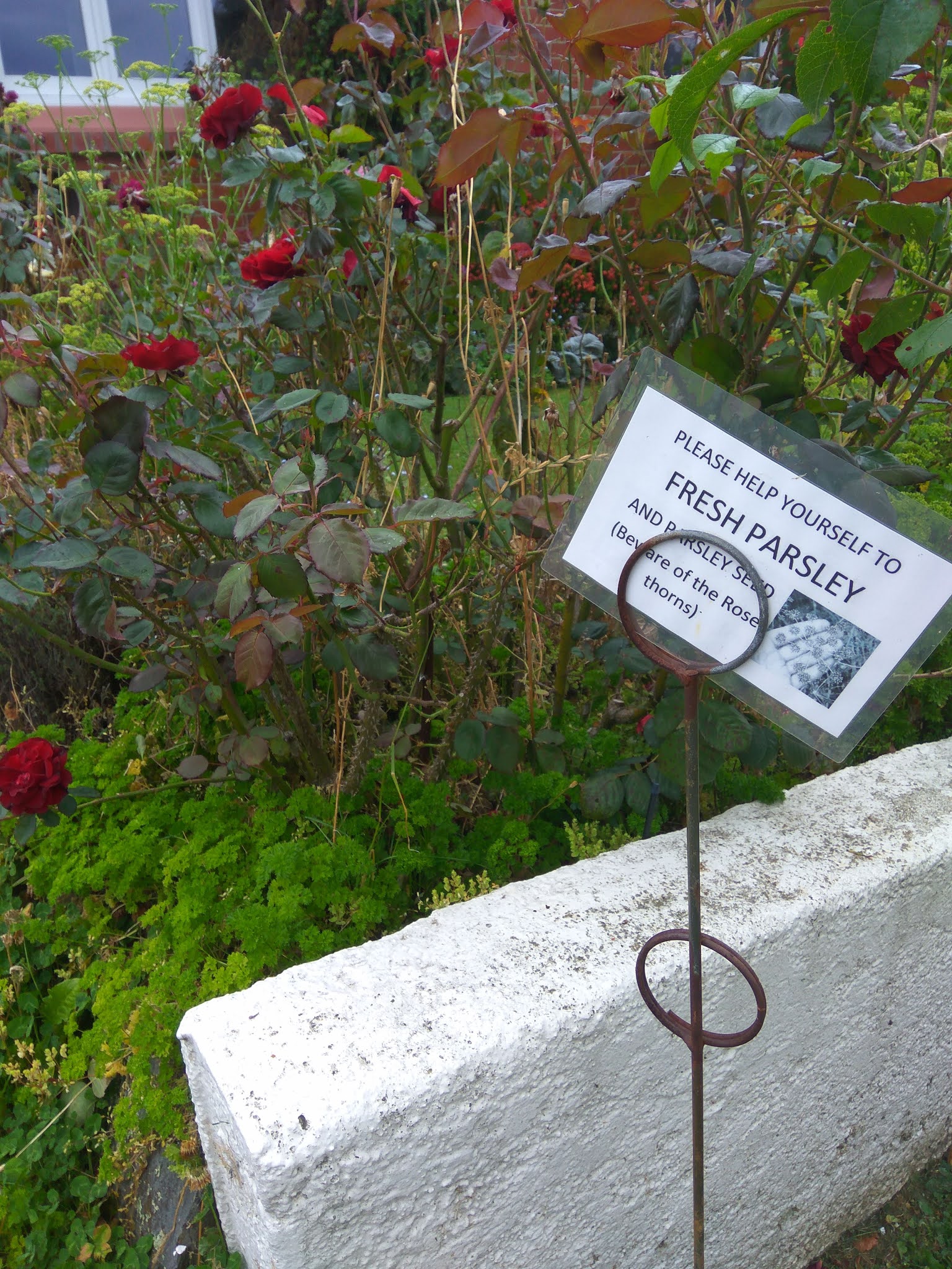
I saw quite a few interesting things on my walk today.  It is always a bonus to find friendly residents sharing the produce from their gardens and there is a lot of parsley hiding among the roses at this house.  They have also placed a seat outside their fence for people to stop and rest on while walking up the hill.  


I have come across some great letterboxes during my walks and this was another one that made me stop and smile. And as I've already mentioned, there were some narrow streets and there were some wide streets and there are also some pretty streets with trees bordering the edge.  I particularly liked these trees as there were lots of leaves for me to kick as I walked up the hill.

Finally I'll share this photo taken in View Park Lane.  It seemed a bit strange to have two street signs in the one street, obviously the houses on one side have a street frontage on Chamberlain Street but does that mean they also have two letterboxes? 


Distance walked:  5.9 km      Walking time  1 hr 14 mins    

Total distance: 309.3 km       Total walking  58 hr 09 mins


Otago Harbour Cycleway 30 October 2023

With my sister in town, it seemed a shame to waste a calm, sunny day so the two of us hopped on a bike each to enjoy the recently opened 32k...