Showing posts with label botanic gardens. Show all posts

Monday, April 3, 2023

#43 of 100 trips for 100 years - Gardens-Cleghorn Street-Signal Hill 2 April 2023


The sun was shining and with warm temperatures 11 people enthusiastically gathered at the Gardens corner for a walk that would take us to the top of Signal Hill/Te Pahuri o te Rangipohika.  The first part of our walk took us along  the relative flat of North East Valley and past Baldwin Street where we dodged a number of tourists intent on getting their photo's of the steepest street in the world.  Once we reached Normanby the gradient increased and the scenery started to change as we left the footpath and began the climb up North Road towards Upper Junction.  The higher we climbed the narrower the road and the more rural the views became. Soon we were passing grassy paddocks with sheep and cows who lazily watched us pass. 
After about 5km of walking we reached a seat with a wonderful view looking back towards the city and it was here that we stopped to regroup before turning onto Cleghorn Street.  It was about this time that the first spots of rain started to fall and with surprise we realised that what had initially looked like a lovely sunny day was turning into something not quite as promising as we'd thought with the top of Signal Hill/Te Pahuri o te Rangipohika now being covered in cloud .  We found a sheltered spot under some large trees where we stopped for a snack and on went our jackets.  The next part of our walk took us through a gate and into a farm paddock where we continued climbing upwards while dodging a few cow pats.  Thankfully the cows kept their distance and didn't show any interest in our antics.
 
The rain really made it's presence felt as we were buffeted by the wind and rain in the open.  We were thankful once we got into the lee of the hill and it was quite pleasant to be able to stop out of the wind and look around.  Unfortunately there wasn't a lot to see other than the inside of a cloud and so we continued climbing up, over a style and past a stand of pine trees to the 393m summit of Signal Hill/Te Pahuri o te Rangipohika.  Quite a good height gain as we had started at just 20m above sea level. 
Sadly being in the fog, we had no view at the top so we didn't linger for long and immediately headed down the more sheltered side of Signal Hill/Te Pahuri o te Rangipohika. The downhill was much easier going and the rain seemed to ease making for more pleasant walking.  We stopped at the Signal Hill Lookout for lunch and were surprised at the how many people drove to the lookout to take photos of  . . . .the inside of a cloud.  After lunch we wandered down the cycle trails that lead down to Logan Park and as we descended we dropped below the cloud giving us the chance to see a little further ahead. 
Stopping to regroup at each intersection we took some of the steeper bike trails to make our progress down much quicker. Once at the bottom of the hill, the rain decided to make it's presence felt again and we sheltered under some trees while the worst of it past. Emerging from the trees, it was a fast walk along the road and through the Gardens back to the Gardens corner 12.2km after we had started - and on one of the wettest day trips so far in the 100 trips.  


Sunday, December 18, 2022

#19 of 100 trips - Gardens / Upper Junction / Blanket Bay / return to Dunedin Gardens 17 December 2022

Five intrepid trampers met at the Gardens corner to recreate one of the early tramping trips of the Otago Tramping Club which involved a lot of road walking which, for the early trampers, would have been on narrow, winding gravel roads but for us was on mostly narrow, winding sealed roads and a wide, flat, smooth cycleway.   We were quietly confident that the sea fog would lift by the time we had reached Upper Junction so that we would be able to see the views, little did we realise how wrong we were.  Meeting at the Gardens corner we set off walking up North Road towards Upper Junction.
The first two and a half kilometers has only a mild gradient and the time went quickly as we walked and chatted our way up North East Valley.  Once we reached Normanby the gradient increased and the sea fog seemed to come lower down the hill so that it felt like it wouldn't be long before we walked into it.  It was a nice surprise to meet my father out for his morning walk and we stopped for a brief chat before continuing on.  Only a short distance on the footpath ran out and we were walking along the edge of the road. 
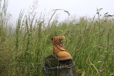
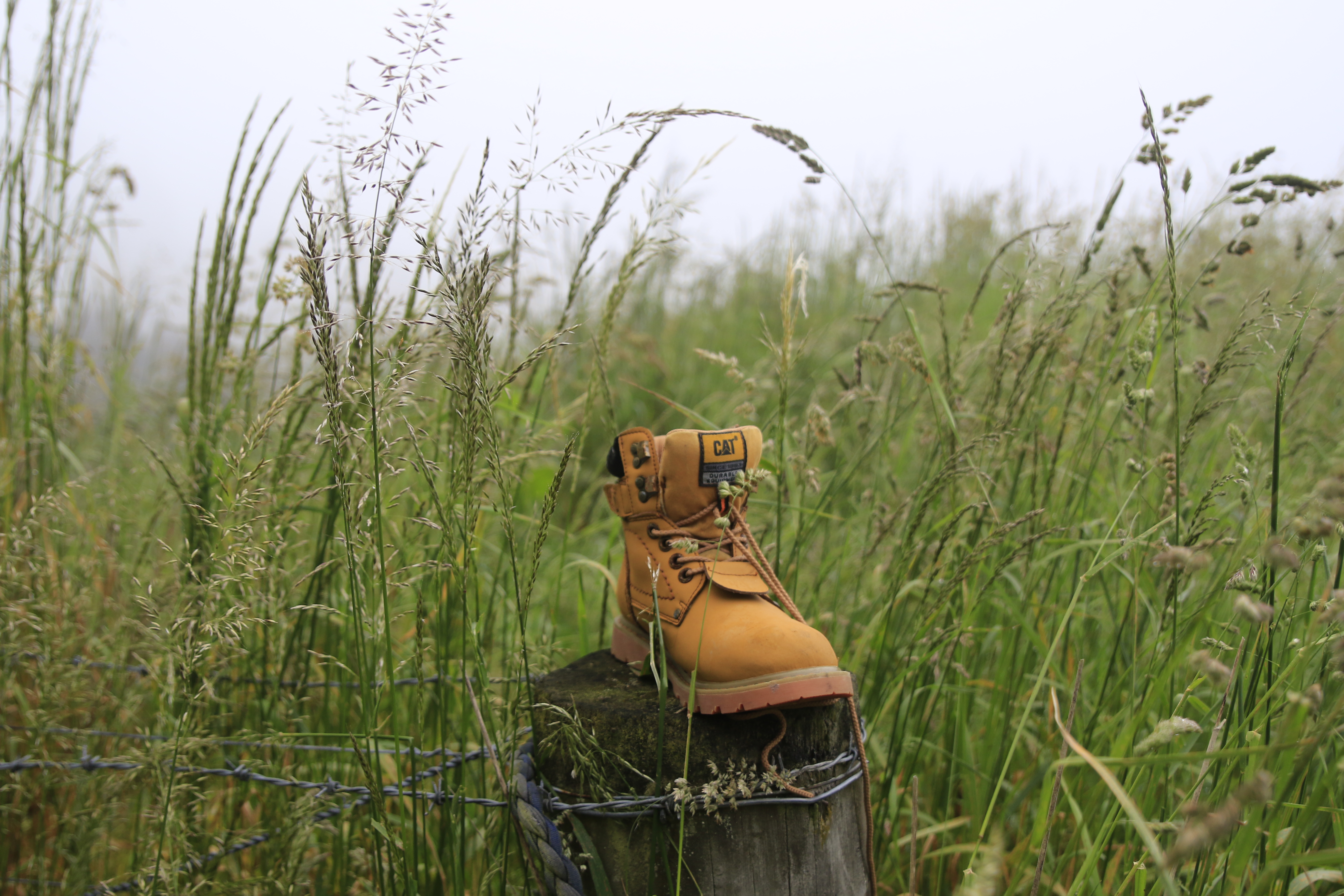
One of the reasons for the early start to the walk was to avoid the traffic on this part of the road and for the most part it worked with only spasmodic traffic. The higher we climbed the thicker the fog became and by keeping well to the side of the road, we didn't disrupt any traffic.  One of the good things about road walking is that the slower pace means that you get time to see things that you'd normally miss when driving past which is exactly what we did - chatting to passing cyclists, listening to the birds, spying bugs in the long grass, watching the sheep and cows (who were watching us), admiring the flowers and our most unusual find was one new, unused boot. 
The higher we climbed the thicker the fog/mist became so that when we reached the highest point at Upper Junction, disappointingly there was no view.  Instead of admiring the view of North East Valley and the city that was hidden to us, we took a small detour to visit the war memorial on the site of the former Upper Junction School that was destroyed by fire in 1945.  There are 17 beech trees planted beside plaques in remembrance of former pupils who were killed during the first world war. This is a particularly poignant war memorial for me as my fathers uncle has a plaque and beech tree planted in his memory here.  John Williams was 17 when he signed up, lying about his age so that he would be accepted into the army and killed at the Somme, aged just 19 years.  It seemed very fitting with the muted light from the  mist swirling around the hundred year old giant macrocarpa trees creating an ethereal atmosphere during our visit of this site.
What goes up must then come down and that is exactly what we did, heading 300 metres down hill on Upper Junction Road, all the way to sea level.  It seemed almost impossible but the mist seemed to grow thicker and we were barely able to see each other at times.  The striking views were non-existent so had to keep an ear open for cars to avoid being hit on the narrow, winding road.
As we dropped lower the mist slowly started to thin until we dropped below it and finally got our first views of the surrounding farmland and down to the harbour. We stopped on a sweeping bend where we could get well off the road for a morning tea break.  Replenishing ourselves with a drink and snack while admiring all that we could see.  With the hills on the opposite side of the harbour and most of the city being shrouded in fog, we were only able to see down to Blanket Bay and Roseneath. 
Knowing that most of the hill was behind us, we continued down the hill where we eventually met up with the main road to Port Chalmers, State Highway 88.  We admired the yet to be completed new cycleway/walkway including the blue surface from a distance. Despite the cycleway looks like it is completed, there are large fences stopping access  so we continued walking along St Leonards Drive.
A lunch stop was called at St Leonards Park where Mandy found a swing to sit while the rest of us opted for the picnic table.  Lindsay arrived with his dog and a box of cherries which he shared while we watched a large ship sail past on it's way to the inner harbour.  By now we were over halfway through our walk and were about to start on the 'easy' part of our walk, along the flat cycle/walkway which runs beside the railway line.  This proved to be more difficult than first thought as the 8km of flat, hard surface made for tired legs and feet.  The fog was lifting with the views of the harbour opening out and we were able to distract each other by seeing who could spot the most interesting sight.  Some of the interesting things we saw were kayakers getting tooted at by the harbour tug for being in the main shipping channel, swimmers jumping off the harbour channel markers, a speedboat jumping the tug boats wake, a grey spoonbill, a few sad, rotting boats, some exercise equipment, lots of walkers and only a handful of cyclists but no trains. 
Once we reached the stadium we turned off the cycle/walkway and continued past the University, skirted around a cricket match in progress and wandered through the student housing until we reached the Water of Leith. We followed the Water of Leith through the Gardens and back to the main gates where we had started 5.5 hours and 21km earlier.

Tuesday, September 7, 2021

Day Eighty Five Opoho

I took advantage of the spring weather and lengthening daylight hours by walking the streets of Opoho today.  I walked 14 streets.

1070. Signal Hill Road
1071. Grandview Crescent
1072. McGregor Street
1073. Colin Street
1074. Evans Street
1075. Warden Street
1076. Torridon Street
1077. Windsor Street
1078. Comely Bank
1079. Hatfield Street
1080. Balmoral Street
1081. Opoho Road
1082. Opoho Loop Road
1083.  Northfield Avenue
 
I started my walk at the top of Opoho at the Signal Hill Lookout.  This is a great place to be able to look over the city and for me, it was a fantastic place to be able to look out and know that I have walked every street that I could see. 

The Signal Hill Lookout also gives good views of the hills surrounding the harbour.  I have also walked every street that I can see on these hills.  There are still some streets further down the harbour that I need to walk but it is very satisfying to know that I have walked everything that I can see from here.

At the lookout is this stone taken from the rock that Edinburgh Castle in Scotland stands on.  Dunedin (Dùn Èideann) is the gaelic name for Edinburgh with many of the early settlers to the city coming from Scotland.  This stone was gifted to the city from Edinburgh in Scotland in 1941 during the city's centenary. 

As I walked down the hill from the lookout, views of the city in different directions opened up and again I have walked every street that I can see.  

The views of the city kept changing as I walked down the hill.  I was able to see city from different angles.  Dunedin is a very pretty city with it's hills and green areas.

It was great to be able to look down to North East Valley and over to Pine Hill.  I have been walking these streets in North East Valley during the last few days.  

 I walked past Tannock Glen today, it is one of Dunedin's hidden gardens.  Since 1975 the Dunedin Rhododendron Group have been planting and maintaining a selection of rare rhododendrons in this magical woodland garden.  It is well worth a visit during any time of year but particularly when the rhododendrons are in flower. 
During my walk today I walked past this lovely stone barn.  There were other stone buildings and fences nearby as well.  All the buildings look to be weatherproof and still in use. 
 
 
I saw different breeds of sheep on my walk today.  One set was most unusual with black and white markings while the other set were the more traditional white. 
 
Today I saw another couple of cute letterboxes. One is a cousin to the red one I saw yesterday and the other has the numbers in words. 

Distance walked:  7.8  km         Walking time  1 hr 31 mins  
 
Total distance: 684.8 km        Total walking  128 hr 23 mins 

Saturday, March 6, 2021

Day Thirty Seven Maori Hil

It was an interesting walk today where I walked some wide streets and also some very narrow streets.  Today I walked 12 streets.

474. Cosy Dell Road
475. Kyle Street
476. Ailsa Street
477. Lachlan Avenue
478. Highgate
479. Henry Street
480. Falkland Street
481. Lothian Street
482. Pollock Street
483. Como Street
484. Viewpark Lane
485. Chamberlain Street

I made a slight error in judgement today because I first walked down one of the paths through the town belt as I intended to start further down the hill.  Unfortunately the path I took didn't take me to the street that I thought I was going to start on and instead I ended up being further away than I had planned.  Not that it was much of a problem because I just kept walking until I got to where I was supposed to be and it also meant that I walked a few 'extra' streets.  

One of those extra streets was Kyle Street which was unusual as it was a narrow street through a tunnel of trees. I had no idea where it was taking me.  At the other end of this street was a tennis court and a few houses.  I did wonder why Kyle Street needed yellow no stopping lines as it is clearly not wide enough for anyone to park in. 

My earlier mistake through the town belt meant that I was on the outskirts of the University student flatting area and it was very obvious the difference in the state of the streets to anywhere in the city that I had already walked.  It is a shame that students seem to think that it is OK to just walk away from their rubbish. 


From Lachlan Avenue and Ailsa Street there are good views of the Dunedin Botanic Gardens which is the part with all the large green trees behind the student flats.  The Dunedin Botanic Gardens is the oldest botanic gardens in New Zealand and was established in 1963.  The botanic gardens forms the end of the town belt.

Once I started walking back up the hill, the views started to open out again and I was rewarded with a better view of the Dunedin Botanic Gardens with the University student flats in front,  Opoho behind the gardens and North East Valley to the left.  I have not walked any of these streets yet.

As I mentioned earlier there were some narrow streets that I walked today where cars needed to park half on the footpath.  One of the narrowest that I walked was View Park Lane.  It is so narrow that there is no vehicle access to the street but it has a street sign and the houses have letter boxes which means that I can count it towards my challenge of walking every street in Dunedin

And the next street over from View Park Lane is Chamberlain Street which is very wide and has a great view where as View Park Lane does not have view or a park.  I found these two streets a complete contrast to each other. 

I saw quite a few interesting things on my walk today.  It is always a bonus to find friendly residents sharing the produce from their gardens and there is a lot of parsley hiding among the roses at this house.  They have also placed a seat outside their fence for people to stop and rest on while walking up the hill.  


I have come across some great letterboxes during my walks and this was another one that made me stop and smile. And as I've already mentioned, there were some narrow streets and there were some wide streets and there are also some pretty streets with trees bordering the edge.  I particularly liked these trees as there were lots of leaves for me to kick as I walked up the hill.

Finally I'll share this photo taken in View Park Lane.  It seemed a bit strange to have two street signs in the one street, obviously the houses on one side have a street frontage on Chamberlain Street but does that mean they also have two letterboxes? 


Distance walked:  5.9 km      Walking time  1 hr 14 mins    

Total distance: 309.3 km       Total walking  58 hr 09 mins


Otago Harbour Cycleway 30 October 2023

With my sister in town, it seemed a shame to waste a calm, sunny day so the two of us hopped on a bike each to enjoy the recently opened 32k...