Showing posts with label school. Show all posts

Sunday, November 21, 2021

Day 116 Port Chalmers & Careys Bay

Today was a longer walk as I combined finishing the streets in Port Chalmers with walking the streets in Careys Bay.  I walked 22 streets today

1561. Bernicia Street
1562. Bellevue Place
1563. Fox Street
1564. Meridan Street
1565. Harrington Street
1566. Laing Street
1567. Burns Street
1568. Daly Street
1569. Mount Street
1570. Church Street
1571. Ajax Road
1572. Borlases Street
1573. Blueskin Road
1574. Kohi Place
1575. William Street
1576. Coombe Hay Terrace
1577. Harbour Terrace
1578. Cemetery Road
1579. Willmott Street
1580. Slant Street
1581. Henry Street
1582. Macandrew Road
 
My walk today took me over the top of the hill at Port Chalmers, although I did have to walk up and down the hill a couple of times as I walked each street completely.  
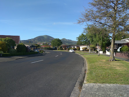
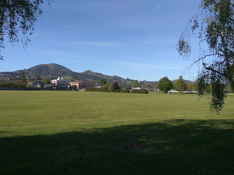
The houses on the streets that I was walking today were positioned on the hill so that they looked either towards the harbour or towards Mt Cargill.  Today the harbour was calm with great reflections of harbour cone. 
Mt. Cargill has dominated the view in many parts of the city that I have walked although I haven't seen it from this angle before.  Mt. Cargill has the transmitter on it with Buttars Peak beside it and Mt Holmes further along.
 
Port Otago is obvious from most streets in Port Chalmers.  I have been able to see the crane gantries and ships or hear the noises from the port during my walk of the streets.

Having seen the Iona Church from most parts of Port Chalmers, this is as close as I got to walking past it.  Built from Port Chalmers Blue Stone and Oamaru Stone, Iona Church was built in 1872 and is still used for services today.

After walking past Iona Church, I continued walking up the hill behind Port Chalmers.  This was a great place to be able to see the streets that I have been walking.  It is always a good feeling looking back and knowing that I have walked every street that I can see.

As I walked further up the hill, I crossed the railway line.  I have been around this railway line many times during my challenge to walk every street.  From here I had beautiful views looking down the harbour towards the city and closer are the houses of Roseneath.

Eventually I walked all the way to the Robert Scott Memorial Lookout.  The views from the look out are fantastic and I was able to see most of Port Chalmers, both Goat and Quarantine Island in the middle of the harbour and harbour cone on the peninsula behind. 

I was also able to look down onto the port with two container ships.  It was fascinating to watch the gantries and straddle carriers moving about, lifting and loading containers.  From this height everything looks small, however I remember how big and high the rows of containers were when I was walking down near them.

 
Built in 1913, the Scott Memorial commemorates the ill-fated Scott expedition that left Port Chalmers for Antarctica on 19 November 1910

Also at the site of the Scott Memorial is this large iron anchor from an unknown sailing ship that often got caught in local fisher nets, it was hauled ashore in 1978.

From the lookout, I took a track past the Port Chalmers cemetery to Careys Bay which is the next bay around from Port Chalmers.  The streets of Careys Bay are steep and the houses are nestled amongst native bush.

Most of the houses in Careys Bay have a view of the marina and habour.  Today the habour was calm with no wind and it was a beautiful place to be walking. 

 
Careys Bay is also close to Port Otago.  It was easy to see from this angle how much the port dominates the area with the containers stacked high.

Once down from walking the streets on the hill, it was nice to be beside the sea and watch the boats bobbing on the harbour while I walked back along the road around the bottom of the hill.

 
One of the lovely old buildings I walked past today is the Chick's Hotel beside Port Otago.  Built in 1876, Chicks operated as a hotel and more recently a music venue until it closed in 2016. 

The Careys Bay Hotel was another historic hotel that I walked past today.  Built in 1874 from Port Chalmers Blue Stone, the hotel has been continuously serving alcohol and today is a popular seafood restaurant particularly during weekends.
Another historic building that I walked past was the old Port Chalmers School.  There has been a school at Port Chalmers since 1856 on various sites.  This school building has been turned into a home.
 
I walked past the memorial to where the local Ngāi Tahu sold the Otago block to the New Zealand Company in 1844.

I have often driven past this large tree that has grown beside the road.  The footpath goes around the tree and it is obviously a notable tree but there was no plaque or sign to say why. 
 
The bus stop at Port Chalmers is painted to match the suburb with a boat, the harbour and Mt. Cargill as the main features. 

I walked past three interesting letterboxes today.  The house shaped letterbox was similar in shape to the house that it belonged to and the castle letterbox looked nothing like the house that it belonged to.  I thought the anchor letterbox was very appropriate for the home it belonged to - near the sea.


And finally, below is the map of the streets that I have walked in Port Chalmers and Careys Bay as well as Sawyers Bay and Roseneath. 
 
 Distance walked:  10.9 km         Walking time  2 hr 3 mins    

Total distance: 960.5  km          Total walking  179 hr 11 mins 

Saturday, November 6, 2021

Day 110 Mosgiel

My plan today was that if I have a longer walk, I would be able  to finish walking the streets of Mosgiel.  I walked 27 streets today.

1470. High Street
1471. Green Street
1472. Victoria Street
1473. Wickliffe Street
1474. Tudor Lane
1475. Kent Place
1476. Windsor Place
1477. Haggart Alexander Drive
1478. Balmoral Avenue
1479. Owhiro Avenue
1480. Glenimire Close
1481. Tuwhare Lane
1482. Beech Street
1483. Cedar Crescent
1484. Oak Place
1485. Elmwood Drive
1486. Ash Place
1487 Cornish Lane
1488. Doon Street
1489. Spey Street
1490. Dunbar Place
1491. Gretna Place
1492. Arran Street
1493. Lomond Place
1494. Kelso Place
1495. Glenbrook Drive
1496. Glenleigh Place

I have become used to seeing Saddle Hill from this angle and today is the last day of walking streets that I will Saddle Hill from this angle as my goal for the day is to finish walking the streets of Mosgiel. 

I walked a mixture of streets of long, straight streets and shorter, curved streets.  The long, straight streets were wide and tended to have older houses

While the shorter, curved streets had newer houses and tended to have more trees and grass verges. 

 
Most of the streets I walked today had a view of Saddle Hill.  I have enjoyed seeing Saddle Hill, occasionally it has been covered in cloud although mostly, like today, I have had an excellent view of it.

 
Some of the newer subdivisions have a view of the Chain Hills and have lots of landscaping on the surrounding streets which makes them very enjoyable streets to walk though.

I walked past a number of playgrounds and sports fields today.  Mosgiel has a lot of playgrounds and sports fields and it has been great when I have come across these open, green spaces as it has given me the opportunity to see something other than streets and houses.  

Today I walked past Taieri College.  Taieri College started in 1871 when it was known as Mosgiel District High School and by 1882, there were over 170 students at the high school. In 2004, the high school merged with Mosgiel Intermediate to become Taieri College and now has over 1200 students. This year is the schools 150th anniversary.

 
I walked past some interesting letterboxes today.  I really liked the one painted with New Zealand's native birds and I thought the one with the 'person' leaning on the letterbox was clever.

 And finally, after 10 days and 93.5km of walking, I have completed walking the streets of Mosgiel.

 Distance walked:  13.2 km         Walking time  2 hr 16 mins  

Total distance: 911.4  km          Total walking  170 hr 01 mins 

Tuesday, October 26, 2021

Day 104 Mosgiel

 Today I was back walking the streets of Mosgiel where I walked 11 streets.

1382. Park Street
1383. Bishop Verdon Close
1384. Laing Street
1385. Cargill Street
1386. Church Street
1387. Glasgow Street
1388. Irvine Street
1389. Argyle Street
1390. Lanark Street
1391. Montrose Street
1392. Berwick Street
 
Like yesterday, the streets I walked today are long, straight and flat.  Today there was cloud/fog covering most of Saddle Hill. 
Whichever direction I walked today, the views were pretty much the same.  Walking the flat can become monotonous as each street starts to look the same and I need to concentrate to make sure that I don't miss any streets. 

I walked all of Church Street today and in Church Street is this impressive Presbyterian Church dating back to 1912, which I am guessing the street is named after.  It looks like there have been some modern touches added with the glass front.

Also in Church Street is the St Mary's School.  Originally founded in 1892, the catholic school was held in the church until 1912 when this building was available and the school with around 50 students moved in.  In the 1950's the roll had grown and a new school was built nearby.

Another interesting building that I walked past is the old fire station that has been turned into a theatre and is home to the Taieri Dramatic Society. Founded in 1949, the Taieri Dramatic Society held two shows a year in the Mosgiel Coronation Hall until it purchased the old fire station in 1989 and now has it's own home.

I walked past this tanawha painted on the side of a building.  Maori legend has it that Saddle Hill is the remains of the tanawha Matamata which was the guardian of a Maori chief and warrior who lived in a village beside the Otago Harbour.You can see that the back and head of the tanawha are in the shape of Saddle Hill.
 I also walked past this wall that is a beautifully painted ANZAC memorial.  The painting is very large as the soldiers are painted in life size. 
I have not seen many interesting letterboxes lately so I was very pleased to see this fun All Blacks letterbox during my walk today.
This map shows the streets I have walked in red.  It is easy to see how many streets in Mosgiel I have walked compared to the streets that I still need to walk.
Distance walked:  8.5 km         Walking time  1 hr 30 mins   
 
Total distance: 859.5  km          Total walking  160 hr 50 mins 

Saturday, August 21, 2021

Day Eighty Liberton

I enjoyed my walk in the sunshine around the streets close to home today.  I walked 20 streets

986. Raleigh Street
987. Hillary Street 
988. Dover Street
989. Lowe Street
990. Tasman Street
991. Tensing Street
992. Egmont Street
993. Allenby Avenue
994. Blundell Street
995. Hislop Street
996. Wilkinson Street
997. Truby King Crescent
998. Pryde Street
999. Croydon Street
1000. Barclay Street
1001. Buccleugh Street
1002. Glencairn Street
1003. Gladstone Road
1004. Forrester Avenue
1005. Newhaven Street
 
 It was a frosty start to the morning and I walked gingerly around the streets that were still in the shade.The first group of streets I walked around are all named after mountains and climbers.  Hillary Street and Tensing Street being the most obvious along with Lowe Street for climbing Mount Everest. Tasman and Egmont are New Zealand mountains and Dover is a mountain in Antarctica.
Many of the streets in Liberton have great views.  Some of the streets have good views of Flagstaff and look towards where I was walking yesterday.
Streets on the other side of the hill have great views looking towards the city.  After stopping to admire the view, I walked down the hill to then walk back up to where I started.
The further down the hill I walked, the views changed to looking towards Opoho and North East Valley.  The road also became very narrow as it grew steeper the nearer I got to the bottom.

The residents of these houses have very steep sections/gardens and very little parking but the views they get are outstanding. These are streets that I have not walked yet.

Of course what goes down must also go up and some of the up was quite steep but as I walked up the hill, I was reward with more great views.   This is looking towards Opoho and are streets that I have not walked yet.

The higher I walked up the hill, the views changed and I was able see over to the Dunedin Botanical Gardens with a glimpse of the harbour and Waverley beyond.

And as I neared the crest of the hill, the view changed back to Flagstaff.  The weather is beautiful and the views have been fantastic today. 

I stopped to have a look at the Dalmore Reserve which has been turned into a community vegetable garden.  The garden is a little overgrown after the winter but it does have great views of the city.
One of the more sad things that I have walked past during my challenge of walking every street in Dunedin is this wooden seat which has a fantastic view of the city.  The seat is dedicated to baby Mae. 
Today I walked past three interesting letterboxes.  One is an ordinary letterbox that is painted like a house while another has used a large piece of interesting wood to cleverly create a letterbox and the third letterbox has been decorated with mosaic tiles.


The ultimate in recycling is this used chain to make the house number on the fence.

The Pine Hill bus stop has been beautifully painted with scenes of the early Pine Hill School. The scenes are taken from old photographs of the school and have been faithfully replicated in the bus stop.


Distance walked:  11.2  km         Walking time  2 hr 10 mins  
 
Total distance: 653.0 km        Total walking  121 hr 52 mins 

Otago Harbour Cycleway 30 October 2023

With my sister in town, it seemed a shame to waste a calm, sunny day so the two of us hopped on a bike each to enjoy the recently opened 32k...