Showing posts with label motorway. Show all posts

Sunday, November 7, 2021

Day 111 Kinmont Park

The sun was shining and the temperatures were very warm as I walked the streets in Kinmont Park today where I walked 16 streets.

1497. Riccarton Road East
1498. Cuddie Close
1499. Elizabeth Avenue
1500. Orchard Gove
1501. Jaffray Drive
1502. Fairmile Drive
1503. Braeside
1504. Clyde Street
1505. Leith Street
1506. Gebbie Street
1507. Kinmont Crescent
1508. Quarry Road
1509. Woodland Avenue
1510. Boundary Road
1511. Dee Street
1512. Tweed Street

The weather was shaping up to be quite hot so I was out walking early in the morning to beat the heat.  I walked the few streets in East Taieri before walking the streets in Kinmont Park.
It was in East Taieri that I had one of my last views of Saddle Hill before moving onto other areas of Dunedin that I haven't walked. 

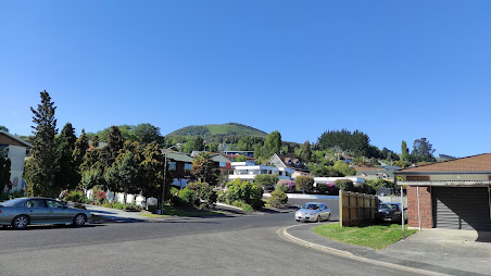
Kinmont Park is on a hill that overlooks part of Mosgiel and it was here, that I was finally able to see over Mosgiel where I have been walking for the last 10 days. After the flat streets of Mosgiel, it was great to be walking on the hills again.

 
 As I walked around the streets in Kinmont Park, I was rewarded with a view in another direction, looking towards East Taieri and Maungatua.

And then I was at the bottom of the hill, looking back up to where I had been walking.  Kinmont Park is on the lower slopes of Saddle Hill and I was able to see the rounded back of Saddle Hill at the top.  

My next destination was to the streets below the Mosgiel sign.  Each letter  of the Mosgiel sign is 3m tall and was put up by the local Rotary club in1987.  The sign is visible by the traffic as it travels past on State Highway 1.

Before reaching the Mosgiel sign, I walked the bridge over State Highway 1.  This is the main road that travels the length of the country and, at times, can be very busy.  Early on a Sunday morning is not one of those busy times.

From the bridge over the motorway I was able to see all the streets that I had walked in Kinmont Park. 

Once over the bridge, I walked a street that bordered an area where I had walked a few days ago where there is a subdivision with new houses being built.
 
Then all I had to do was cross the bridge again and walk up the hill,taking a street that was on the edge of the suburb with houses on one side and peaceful green fields with sheep on the other. 

An interesting part  of my walk today was along the street at the base of the hill that the Mosgiel sign is on.  Sometimes called Mollywood after the famous Hollywood sign, the sign has been here for 35 years and is lit up at night.

I walked past two letterboxes of interest today.  I really liked the tall house letterbox and I thought the number 7 was great too.
Distance walked:  12.2 km         Walking time  2 hr 12 mins   
 
Total distance: 923.6  km          Total walking  172 hr 13 mins 

Friday, August 20, 2021

Day Seventy Nine Pine Hill

New Zealand is in Lockdown  Alert Level 4 which is our highest level of restrictions due to an outbreak of Covid 19 in the community. It means that I am only allowed to exercise locally.  I have not walked the streets close to home as I had thought if NZ was to go into Lockdown, then I would be able to continue my walking the streets of Dunedin.  Today I walked 3 streets

983. Pine Hill Road
984. Maxwellton Street
985. Patmos Avenue

I started my walk by walking up the hill towards Mt Cargill from my home.  It only takes about 10 minutes walking to reach farmland and the views of the city really start to open up. It was a good feeling looking at this view knowing that I have walked every street that I could see. 

As I walked around the hill  I was rewarded with a view of Pine Hill which is where I live.  I still need to walk these streets but with Lockdown, these will be the next streets that I will be walking. 

 As I started walking down the hill to Leith Valley I crossed over a bridge that goes over the Northern Motorway.  This is State Highway One and is the main road to get into the city from the North.  Normally this is a very busy road but as we are in Lockdown and the only travel allowed is for essential services (e.g. food and medicine) there was very little traffic. 

On my walk I caught a glimpse of the magnificent house built by Dunedin's first bishop.  This house is huge and was built in the 1880's by the the first Bishop of Dunedin who lived here for 50 years and raised a family of five children.
At the entrance to the property once owned by the first Bishop is the gatehouse which is, itself, a beautiful home.  The gatehouse is much smaller that the main house.

Spring is definitely in the air and it was wonderful to walk past these trees covered in beautiful blossom.  I have walked past these trees before back in April when they were losing their leaves.  

 
And finally I walked back up the hill towards home by walking up Pine Hill Road, and over the bridge over George Street which is the main street of Dunedin.  As it is Lockdown, the streets are very quiet with no traffic today. 

It might seem a strange photo but this fence is a new fence, only a few weeks old,  that replaced a very old fence that ran up the side of the road.  This is a much nicer and safer fence.  

 
Looking over the side of the fence part, I could see that road has been built up with most of the road not actually on the ground but suspended on a bridge. 

On my walk today I walked past a number of these traps which are part of the Halo Project.  The Halo Project maintains a number of predator traps to protect the native wildlife.  There are a variety of traps for possum, stoats and rats around the fringes of the city that are regularly checked by volunteers

To show that half my walk was past farmland on the edge of the city, here are some of the farm animals that I walked past today.


I walked past this lovely stone fence built from the stones that the farmer cleared from his paddocks.  This is a very old style way of making a fence but this fence is only a few years old.

I walked past these two letterboxes.  One is painted with a kereru (NZ wood pigeon) and the other is shaped like a man going walkabout.

Lastly is this painted telephone cabinet that I walked past today. 


Distance walked:  10.4  km         Walking time  1 hr 55 mins  
 
Total distance: 641.8 km        Total walking  119 hr 42 mins 

Sunday, August 1, 2021

Day Seventy Six Sunnyvale

 I was back finishing walking the streets around Abbotsford and also Sunnyvale.  I walked 23 streets today.

939. Teigmouth Street
940. Totness Street
941. Torquay Street 
942. Exeter Street
943. North Taieri Road
944. McKinlay Road
945. Lambert Street
946. Hyslop Street
947. Freeman Close
948. Abbeyfield Close
949. Will Street
950. Thomson Street
951. Pottinger Street
952. Watson Street
953. Sunnyvale Lane
954. Abbotsford Road
955. Abbotts Hill Road
956. Waldron Crescent
957. Severn Street
958. Tate Crescent
959. Grand Vista Drive
960. Reeves Street
961. Miller Street

The first part of my walk today was to finish streets that I had walked part of yesterday.  Of course these streets all involved walking either up or down a hill.  The good thing about walking hills are the views and, like yesterday, I was able to look over at the streets of Green Island which I have already walked.

 Also like yesterday, Saddle Hill dominated the view.  From this angle it is hard to see why the hill is called Saddle Hill but once I reach the streets of Mosgiel, the shape of the hill will look more like a saddle. 

I was pleased to be able to look down onto the newer part of Abbotsford where I would be walking late in the morning, once I had finished the streets on the hill.  

Another area that I would be walking once I had finished the streets on the hill were the streets of Sunnyvale which behind the sports field. 

As I walked closer to Sunnyvale, I could hear the noise of the traffic on the motorway.  I could also look across the motorway to see streets that I have not walked yet.  

The houses in this area get a good view of the surrounding hills and down onto the streets of Sunnyvale.  I have now walked all the streets in the foreground of this picture.  

I was happy to find four interesting letterboxes today.  Three of them are very solid, metal letterboxes and the forth letterbox has been made interesting by the owners. 


And something else that I spotted that I thought was interesting was both of these gates that are not connected to a fence. Other than holding up the letterbox, I am not sure what the purpose of having a gate that you can walk around.

Distance walked:  12.2  km         Walking time  2 hr 14 mins  
 
Total distance: 616.1 km       Total walking  115 hr 5 mins 

Friday, January 29, 2021

Day Twenty Lookout Point

 It's been a couple of days since I've been able to walk and today I dodged the showers for a short walk to finish off the area between Caversham and Lookout Point.  Today I walked 5 streets.

240. Burnett Street
241. Caversham Valley Road
242. Sidey Street
243. Cole Street
244. Caversham Place

Today I walked one of the scarier streets, walking Caversham Valley Road which is also part of the Southern Motorway and is on the edge of two lanes of traffic.  It is a very busy piece of road and I was glad when I reached  the top of the hill and could turn off onto quieter streets. 


It was good to walk over the bridge at Lookout Point and look down onto the traffic and over the city.  As this is the main road heading South towards Mosgiel and the southern suburbs, it always has a lot of traffic and at certain times of the day, both lanes can be clogged with traffic.


After crossing the bridge, I took a slight detour on Mornington Road to see the Lookout Point Fire Station which was built in 1956 and is right on the side of the motorway. 

After crossing back over the bridge it was nice to get off the busy road and onto the quieter suburban streets.  I enjoyed the gentle gradient and views of South Road and Sidey Street.  

On my walk today I noticed how wall reinforcement methods have changed over time.  First I walked past this nice older concrete wall before coming across the more modern reinforced wall of the bridge.  


I also came across the plaque commemorating the completion of the over bridge in 2015 and in Cole Street there are is this sign beside some lettuce and silverbeet plants.  A lovely gesture by some generous residents. 


Distance walked: 4.2 km  Walking time  53 mins    

Total distance: 167.8 km       Total walking  30 hr 59 mins


Otago Harbour Cycleway 30 October 2023

With my sister in town, it seemed a shame to waste a calm, sunny day so the two of us hopped on a bike each to enjoy the recently opened 32k...