Sunday, January 31, 2021

Day Twenty One (part two) Middlemarch

 After walking through Hyde, I drove 27km down the road to Middlemarch where I walked 18 streets.

247. Snow Avenue
248. Conway Street
249. Mold Street
250. Olive Avenue
251. Garthmyl Road
252. Tawe Street
253. Cardigan Street
254. Clywd Street
255. Brecon Street
256. Milford Street
257. Swansea Street
258. Browns Road
259. Aberfon Street
260. Bank Street
261. Kirk Street
262. Nottage Street
263. South Road
264. West Street

I confess that there are some streets in Middlemarch that I did not walk all of the street because it was not safe.  I walked to the edge of the town and as far as the 100km speed sign and with no footpath, I felt it was not safe to continue further.  

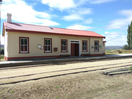
I started my walk at the Middlemarch Railway Station.  The station was opened in 1891 and was part of the Otago Central Railway line.  In 1990, the station and rail line from Middlemarch to Dunedin was taken over by the Taieri Gorge Railway and used for sightseeing train trips up the Taieri Gorge.  Now the train no longer travels as far as Middlemarch and the station is not used anymore.  

At the Middlemarch Railway Station is this 133 year old steam engine which was withdrawn from service and dumped in the Clutha River in 1932 to protect the Roxburgh Branch line from erosion.  In 1992 the remains of the steam engine were discovered.  They were eventually recovered  it is slowly under going restoration. 


Where Olive Street joins Tawe Street is the start (or finish, depending on which way you cycle) of the Central Otago Rail Trail which is a 150km cycle track that follows the old railway line to Clyde.  Built in the 1990's after the railway line was closed the Rail Trail is popular with cyclists.  
 
While Middlemarch is part of Dunedin City it is 80km from Dunedin with a population of around 150 people and lies at the base of the Rock and Pillar Range.   It is good walking the streets of Middlemarch as the streets are flat.  One of the streets I walked, Brecon Street started as a normal sealed street and then soon turned into a dirt road then back into a sealed road.  The views of the Rock and Pillar Range from this (and most) streets  in Middlemarch are stunning. 

 
Walking the streets of Middlemarch, I saw a number of older churches and one of these is St Chad's Anglican Church, which is 'famous' for having the first church bell sound on the Strath Taieri in 1901.  It is also quite unique because surrounding the church is a beautiful old stone wall and incorporated in the wall is a comfortable stone seat which I took the opportunity to rest in the shade.
 
On my walk around Middlemarch I saw a couple of interesting things, one is these beautiful stone arches beside the railway line. The other is this mural on the side of a building that is a map of the Strath Taieri and Middlemarch area. 


Distance walked:  9.4 km  Walking time  1 hr 46 mins    

Total distance: 183.4 km       Total walking  33 hr 53 mins
 

Saturday, January 30, 2021

Day Twenty One (part one) Hyde

 Dunedin is the world's fifth largest city in geographical size and the largest in New Zealand.  Dunedin might be big in land size but it is not the largest in population with around 120,000 people.  Dunedin is sparsely populated with a lot of farmland.  Today I decided to go as far from urban Dunedin as I could which meant I started my walk in Hyde, 107 km from the central business district of Dunedin. Today I walked 2 street in Hyde

245. Eton Street
246. Newtown Road

Hyde was originally called Eight Mile and was a gold rush town in the 1860's with up to 16 pubs, now it is a small town with a handful of residents and is the stopping place for cyclists on the Otago Central Rail Trail.  Hyde only has one main street and it was an interesting walk as this is the first gravel foot path I have walked on.  There are also some interesting things to see, things that I would not have seen had I driven through including this old horse drawn plough on the side of the gravel footpath 


There was, reputably, up to 16 pubs in Hyde and there must also have been a number of churches as well.  Today I could find only 2 remaining churches with both looking like are not used for services anymore. 


There is also the old Hyde school, complete with school bell.  Hyde School dates back to 1869 and was closed in 1999. The school buildings and land have been turned into accommodation for those cycling the rail trail. 

A prominent feature of Hyde is the war memorial with one of original hotels, the Otago Central Hotel behind it.  It is a good place to stop, rest and remember. 
 

 After walking the main road of Hyde, I followed part of the rail trail for 2 km to the old Hyde Railway Station.  It is a well maintained building, built in1894,  with old rail wagons and working points.  This is where I walked the second street in Hyde - Newtown Street which goes from the railway station to the highway.

Inside the station itself, there are information panels and part of the station has been refurbished to resemble what the inside of the station would have looked like when it was a working station in the early 1900's.  The station was once very busy transporting Hyde clay to the pottery works in Christchurch and Auckland. 


 After walking back along the Otago Rail Trail I drove 27 km's down the road to Middlemarch where I continued my goal of walking every street in Dunedin - including all the streets of Middlemarch as it is also part of Dunedin City.   

Distance walked: 6.2 km  Walking time  1 hr 8 mins    

Total distance: 174 km       Total walking  32 hr 07 mins

Friday, January 29, 2021

Day Twenty Lookout Point

 It's been a couple of days since I've been able to walk and today I dodged the showers for a short walk to finish off the area between Caversham and Lookout Point.  Today I walked 5 streets.

240. Burnett Street
241. Caversham Valley Road
242. Sidey Street
243. Cole Street
244. Caversham Place

Today I walked one of the scarier streets, walking Caversham Valley Road which is also part of the Southern Motorway and is on the edge of two lanes of traffic.  It is a very busy piece of road and I was glad when I reached  the top of the hill and could turn off onto quieter streets. 


It was good to walk over the bridge at Lookout Point and look down onto the traffic and over the city.  As this is the main road heading South towards Mosgiel and the southern suburbs, it always has a lot of traffic and at certain times of the day, both lanes can be clogged with traffic.


After crossing the bridge, I took a slight detour on Mornington Road to see the Lookout Point Fire Station which was built in 1956 and is right on the side of the motorway. 

After crossing back over the bridge it was nice to get off the busy road and onto the quieter suburban streets.  I enjoyed the gentle gradient and views of South Road and Sidey Street.  

On my walk today I noticed how wall reinforcement methods have changed over time.  First I walked past this nice older concrete wall before coming across the more modern reinforced wall of the bridge.  


I also came across the plaque commemorating the completion of the over bridge in 2015 and in Cole Street there are is this sign beside some lettuce and silverbeet plants.  A lovely gesture by some generous residents. 


Distance walked: 4.2 km  Walking time  53 mins    

Total distance: 167.8 km       Total walking  30 hr 59 mins


Tuesday, January 26, 2021

Day Nineteen Calton Hill

 It was extremely hot walking today as the temperature rose over 30C.  Today I walked 10 streets.

230. Cuba Street
231. Nottingham Crescent
232. Ryehill Street
233. Waimea Avenue
234. Pladda Street\
235. Columba Avenue
236. Panmure Avenue
237. Mariner Street
238. Milford Avenue
239. Riselaw Road 

I started my walk having to walk up and around Cuba Street and Nottingham Crescent.  It was nice to be rewarded with views of the city from Nottingham Crescent so early in my walk.
 
And I had the bonus of looking across to Corstorphine and see the streets that I had walked yesterday.  It was nice to be able to trace the route I had taken yesterday.  

I also walked along the short part of South Road that is above the motorway on ramp.  This part of the road runs beside the motorway.  It was quite unnerving when a big truck zoomed past with only a concrete barrier separating me from the traffic.  

Then it was up a set of steep steps which took me to Columba Avenue.  Here I ended up walking a complete circle to ensure that I walked the entire street.  There were some good views from Columba Avenue looking towards Concord which is where I will be heading soon.  


Then I got to complete Riselaw Road and headed down Sidey Street.  Sidey Street has great views looking towards Corstorphine and St Clair.  I spent some time here as it was really good knowing that I had walked nearly all the streets that I could see. 

Today I saw two interesting things on my walk.  One was this neat home made letterbox and the other was this boat parked on the side of the road. The boat going no where gave me a good giggle.  


Distance walked: 6.9 km  Walking time 1 hr  25 mins    

Total distance: 163.6 km       Total walking  30 hr 06 mins


Monday, January 25, 2021

Day Eighteen Corstorphine

 The weather was starting to change with cloud coming in so the views today were not as clear as previous walks.  Today I walked 17 streets.

213. Corstorphine Road
214. Traquair Street
215. Crammond Avenue
216. Middleton Road
217. Stenhope Crescent
218. Avondale Street
219. May Street
220. Westgate
221. Hilltop Crescent
222.  Hillhead Road
223. St Clair Close
224. Bruntsfield Place
225.  Dovecote Avenue
226. Clermiston Avenue
227. Summertime Avenue
228. Gilmerton Street
229. Milburn Street

I thought the easiest thing to do was to start today's walk by going uphill so that I could finish with a downhill. Today I started by walking up Corstorphine Road.  There are a number of side streets off Corstorphine Road and these gave me a break from the uphill.  One of these side streets, Crammond Avenue gave me good views of the city.  

Corstorphine Road is not so steep once past Crammond Avenue and I made my way round to Middleton Road then further up the hill to Stenhope Crescent.  I was surprised at how far these streets went and how many houses there are in Stenhope Crescent and the streets that lead off it.  The views form Stenhope Crescent are also worth stopping for a look.  
 
 
From here it was time to turn around and start heading back down the hill.  After walking through Westgate I was onto Hillhead Road.  I had walked part of Hillhead Road on an earlier walk and today I got to walk right to the end.  After passing the houses, Hillhead Road changes into a more rural area.  
 
The end of Hillhead Road is marked on the map as having access to Tunnel Beach but in reality it does not.


From here it was back along Hillhead Road and continue walking the streets of Corstorphine, making my way back to where I started.  I found Corstorphine interesting walking as there are a number of pathways connecting the streets which meant that I only needed to walk one way on some of cul-de-sac streets.  

During my walk today I noticed a few interesting things. One was this cute letterbox.  It is such a happy looking letter box that it made me smile.  Another is the large anchor outside the club rooms of the Otago Underwater Club on the corner of Crammond Avenue and Corstorphine Road


 I was a bit disappointed that the sun was not shining today as I would like to have seen this sun dial in Westgate working.


I really liked this bus stop that I passed today.  Thomas Sidey was a politician who was first elected to government in the Caversham electorate then the Dunedin South Electorate until 1928.  He lived in the family home of Corstorphine House until his death in 1933.  


Distance walked: 11.6 km     Walking time 2 hr  09 mins    

Total distance: 156.7 km       Total walking  28 hr 41 mins


Sunday, January 24, 2021

Day Seventeen Kew

 After looking at the map for yesterday's walk I realised that I had missed a street altogether.  Winston Place comes off Seaview Terrace and does not have a street sign so I had thought it was a private street when I walked past yesterday.  Looking at the street map, I can see that it is a public street and today I corrected my mistake and walked Winston Place before starting the rest of my walk.  

 I enjoyed walking today and concentrated on the streets of Kew.  Today I walked 19 streets

194.Winston Place
195. Forbury Road
196. Fenton Crescent
197. Allandale Road
198. Coney Hill Road
199. Easther Crescent
200. Pencarrow Street
201. Rutherford Street
202. David Street
203. Hazel Avenue
204. Playfair Street
205. Murray Street
206. Embo Street
207. Skibo Street
208. Dornoch Street
209. Lockerbie Street
210. Marewa Street
211. Bangor Terrace
212. Rainton Road
 
One of the first streets I headed up was Fenton Crescent which has access to Francis Hodgkinson Retirement Village.  From Fenton Crescent it is easy to see all the stabilization work that has been done on the hillside and how close to the edge of the cliff the buildings are.  It is also the first street that I have walked that has seats to stop and rest while on the way up the hill.  
 
 I continued on along Forbury Road and did a detour up Allandale Road to Coney Hill Road where I stopped to look at the view over St Kilda and St Clair streets, which I have already walked.


Then it was back down the hill to Forbury Road and along to the steps connecting Forbury Road to Easther Crescent which climb up the hill beside the Francis Hodgkinson Retirement Village.  The retirement village has a prominent position on the hill and is seen from most parts of the city.  The village residents have a fantastic view looking over South Dunedin.  I was happy to have a rest here after walking up the Forbury to Easther Crescent steps. 


From here it was up and down the hill a couple of times as I tried not to miss any streets. After walking down the hill to complete another part of Easther Crescent, I walked along the flat to walk the streets around the Caversham shopping area before heading up Playfair Street and turning off onto Murray Street.  From here the streets wind around and up the hill towards Middleton Road, where I finished yesterday.  All the streets in this area have amazing views.   

From Embo Street the view changes from the city to look towards Balaclava and Maryhill showing me an area that I have not walked yet.  I love how green Dunedin is with all the trees and bush. 

Today I noticed a few interesting things on my walk.  One is this Braeside stone in the wall on the corner of Allandale Road and Coney Hill Road.  I could find anything to tell me what it was for but I am assuming it is the name of the house behind the stone wall.  Sadly I could not see the house as it is well screened from the street. The other interesting thing I noticed was this 'lift' that could be used to transport a person or items up the hill to the house.  I am guessing it is not used anymore as the lift is old and looks to be overgrown through disuse.  

 
I also stopped to admire the Caversham Presbyterian Church with it's spire and beautiful stone work.  It is sad to note that it is no longer in use due to needing earthquake strengthening. 


Distance walked: 11.8 km     Walking time 2 hr  15 mins    

Total distance: 145.1 km       Total walking  26 hr 30 mins


Otago Harbour Cycleway 30 October 2023

With my sister in town, it seemed a shame to waste a calm, sunny day so the two of us hopped on a bike each to enjoy the recently opened 32k...