Showing posts with label rail trail. Show all posts

Saturday, July 31, 2021

Day Seventy Five Abbotsford

 It's been a couple of weeks since I was walking the streets and today I walked 22 streets around Abbotsford.

917. Armstrong Lane
918. Boomer Street
919. Crimp Street
920. Kane Street
921. Harrison Street
922. Christie Street
923. Penrich Street
924. Mitchell Street
925. Percy Street
926. Edward Street
927. Mathew Street
928. John Street
929. Lethaby Street
930. Dall Street
931. Binnie Street
932. Runciman Street
933. Paterson Street
934. Shulma Stret
935. Shipka Street
936. Exmouth Street
937. Unsworth Street
938. Neill Street

Not long after starting my walk today, I walked over the bridge that crosses the Kaikorai Stream.  I have walked beside and over this stream before when I walked the streets of Kaikorai Valley and near Frasers Gully.  

The first part of my walk took me around the streets that border the area where the 1979 Abbotsford slip happened.  Today the area has been transformed into sports fields but prior to August 1979 the area was streets and houses.  Over a period of several months cracks were appearing in the ground and burst water pipes were continually being repaired with most residents voluntarily leaving their homes.  In late July 1979 there was heavy rain which increased the size of the cracks substantially and on 8 August, the hillside slipped away, taking 69 homes with it.  Today the area is peaceful with sports fields.


It must have been a very uncertain time for many people living in Abbotsford, including those living on Christie Street as the houses on one side of Christie Street slipped away and the other side was 'safe'.  This photo is of Christie Street with houses on the right and the land on the left now used for sports fields and animal grazing. 

As Abbotsford is a hilly suburb, there were some good views on my walk today and I was able to look down on the streets that I would be walking later on during my walk.  Saddle Hill dominated a lot of the views today.  

I was also able to look over towards Green Island where I had been walking a couple of weeks ago.  It is good to know that I don't have to walk these streets as I have already done so.  

The railway line runs through Abbotsford and I walked along (and over) the railway line for part of my walk today.  A cycle way is being built beside the railway line. 


In Abbotsford today, I walked past a playground with two names.  This playground is called the Matthew Street playground but in the 1970's it was called the Penrich Playground. 


 I was also able to look down on the playground from above while walking the streets on the hill above the playground.

There was piece of public art that I walked past today, this little girl losing her balloons painted on a fence. 

I saw a couple of interesting letterbox today.  This cow letterbox was near animals grazing and while there were no cows nearby, there were sheep on the other side of the road. And the other letterbox is bright and cheerful with daffodils

 
Distance walked:  11.4  km         Walking time  2 hr 6 mins  
 
Total distance: 603.9 km       Total walking  112 hr 51 mins 

Sunday, January 31, 2021

Day Twenty One (part two) Middlemarch

 After walking through Hyde, I drove 27km down the road to Middlemarch where I walked 18 streets.

247. Snow Avenue
248. Conway Street
249. Mold Street
250. Olive Avenue
251. Garthmyl Road
252. Tawe Street
253. Cardigan Street
254. Clywd Street
255. Brecon Street
256. Milford Street
257. Swansea Street
258. Browns Road
259. Aberfon Street
260. Bank Street
261. Kirk Street
262. Nottage Street
263. South Road
264. West Street

I confess that there are some streets in Middlemarch that I did not walk all of the street because it was not safe.  I walked to the edge of the town and as far as the 100km speed sign and with no footpath, I felt it was not safe to continue further.  

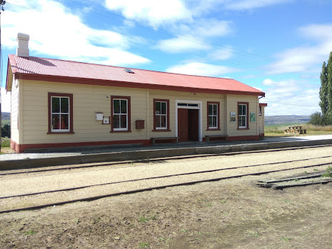
I started my walk at the Middlemarch Railway Station.  The station was opened in 1891 and was part of the Otago Central Railway line.  In 1990, the station and rail line from Middlemarch to Dunedin was taken over by the Taieri Gorge Railway and used for sightseeing train trips up the Taieri Gorge.  Now the train no longer travels as far as Middlemarch and the station is not used anymore.  

At the Middlemarch Railway Station is this 133 year old steam engine which was withdrawn from service and dumped in the Clutha River in 1932 to protect the Roxburgh Branch line from erosion.  In 1992 the remains of the steam engine were discovered.  They were eventually recovered  it is slowly under going restoration. 


Where Olive Street joins Tawe Street is the start (or finish, depending on which way you cycle) of the Central Otago Rail Trail which is a 150km cycle track that follows the old railway line to Clyde.  Built in the 1990's after the railway line was closed the Rail Trail is popular with cyclists.  
 
While Middlemarch is part of Dunedin City it is 80km from Dunedin with a population of around 150 people and lies at the base of the Rock and Pillar Range.   It is good walking the streets of Middlemarch as the streets are flat.  One of the streets I walked, Brecon Street started as a normal sealed street and then soon turned into a dirt road then back into a sealed road.  The views of the Rock and Pillar Range from this (and most) streets  in Middlemarch are stunning. 

 
Walking the streets of Middlemarch, I saw a number of older churches and one of these is St Chad's Anglican Church, which is 'famous' for having the first church bell sound on the Strath Taieri in 1901.  It is also quite unique because surrounding the church is a beautiful old stone wall and incorporated in the wall is a comfortable stone seat which I took the opportunity to rest in the shade.
 
On my walk around Middlemarch I saw a couple of interesting things, one is these beautiful stone arches beside the railway line. The other is this mural on the side of a building that is a map of the Strath Taieri and Middlemarch area. 


Distance walked:  9.4 km  Walking time  1 hr 46 mins    

Total distance: 183.4 km       Total walking  33 hr 53 mins
 

Saturday, January 30, 2021

Day Twenty One (part one) Hyde

 Dunedin is the world's fifth largest city in geographical size and the largest in New Zealand.  Dunedin might be big in land size but it is not the largest in population with around 120,000 people.  Dunedin is sparsely populated with a lot of farmland.  Today I decided to go as far from urban Dunedin as I could which meant I started my walk in Hyde, 107 km from the central business district of Dunedin. Today I walked 2 street in Hyde

245. Eton Street
246. Newtown Road

Hyde was originally called Eight Mile and was a gold rush town in the 1860's with up to 16 pubs, now it is a small town with a handful of residents and is the stopping place for cyclists on the Otago Central Rail Trail.  Hyde only has one main street and it was an interesting walk as this is the first gravel foot path I have walked on.  There are also some interesting things to see, things that I would not have seen had I driven through including this old horse drawn plough on the side of the gravel footpath 


There was, reputably, up to 16 pubs in Hyde and there must also have been a number of churches as well.  Today I could find only 2 remaining churches with both looking like are not used for services anymore. 


There is also the old Hyde school, complete with school bell.  Hyde School dates back to 1869 and was closed in 1999. The school buildings and land have been turned into accommodation for those cycling the rail trail. 

A prominent feature of Hyde is the war memorial with one of original hotels, the Otago Central Hotel behind it.  It is a good place to stop, rest and remember. 
 

 After walking the main road of Hyde, I followed part of the rail trail for 2 km to the old Hyde Railway Station.  It is a well maintained building, built in1894,  with old rail wagons and working points.  This is where I walked the second street in Hyde - Newtown Street which goes from the railway station to the highway.

Inside the station itself, there are information panels and part of the station has been refurbished to resemble what the inside of the station would have looked like when it was a working station in the early 1900's.  The station was once very busy transporting Hyde clay to the pottery works in Christchurch and Auckland. 


 After walking back along the Otago Rail Trail I drove 27 km's down the road to Middlemarch where I continued my goal of walking every street in Dunedin - including all the streets of Middlemarch as it is also part of Dunedin City.   

Distance walked: 6.2 km  Walking time  1 hr 8 mins    

Total distance: 174 km       Total walking  32 hr 07 mins

Otago Harbour Cycleway 30 October 2023

With my sister in town, it seemed a shame to waste a calm, sunny day so the two of us hopped on a bike each to enjoy the recently opened 32k...