Showing posts with label playground. Show all posts

Saturday, July 31, 2021

Day Seventy Five Abbotsford

 It's been a couple of weeks since I was walking the streets and today I walked 22 streets around Abbotsford.

917. Armstrong Lane
918. Boomer Street
919. Crimp Street
920. Kane Street
921. Harrison Street
922. Christie Street
923. Penrich Street
924. Mitchell Street
925. Percy Street
926. Edward Street
927. Mathew Street
928. John Street
929. Lethaby Street
930. Dall Street
931. Binnie Street
932. Runciman Street
933. Paterson Street
934. Shulma Stret
935. Shipka Street
936. Exmouth Street
937. Unsworth Street
938. Neill Street

Not long after starting my walk today, I walked over the bridge that crosses the Kaikorai Stream.  I have walked beside and over this stream before when I walked the streets of Kaikorai Valley and near Frasers Gully.  

The first part of my walk took me around the streets that border the area where the 1979 Abbotsford slip happened.  Today the area has been transformed into sports fields but prior to August 1979 the area was streets and houses.  Over a period of several months cracks were appearing in the ground and burst water pipes were continually being repaired with most residents voluntarily leaving their homes.  In late July 1979 there was heavy rain which increased the size of the cracks substantially and on 8 August, the hillside slipped away, taking 69 homes with it.  Today the area is peaceful with sports fields.


It must have been a very uncertain time for many people living in Abbotsford, including those living on Christie Street as the houses on one side of Christie Street slipped away and the other side was 'safe'.  This photo is of Christie Street with houses on the right and the land on the left now used for sports fields and animal grazing. 

As Abbotsford is a hilly suburb, there were some good views on my walk today and I was able to look down on the streets that I would be walking later on during my walk.  Saddle Hill dominated a lot of the views today.  

I was also able to look over towards Green Island where I had been walking a couple of weeks ago.  It is good to know that I don't have to walk these streets as I have already done so.  

The railway line runs through Abbotsford and I walked along (and over) the railway line for part of my walk today.  A cycle way is being built beside the railway line. 


In Abbotsford today, I walked past a playground with two names.  This playground is called the Matthew Street playground but in the 1970's it was called the Penrich Playground. 


 I was also able to look down on the playground from above while walking the streets on the hill above the playground.

There was piece of public art that I walked past today, this little girl losing her balloons painted on a fence. 

I saw a couple of interesting letterbox today.  This cow letterbox was near animals grazing and while there were no cows nearby, there were sheep on the other side of the road. And the other letterbox is bright and cheerful with daffodils

 
Distance walked:  11.4  km         Walking time  2 hr 6 mins  
 
Total distance: 603.9 km       Total walking  112 hr 51 mins 

Saturday, April 10, 2021

Day Fifty Five Concord

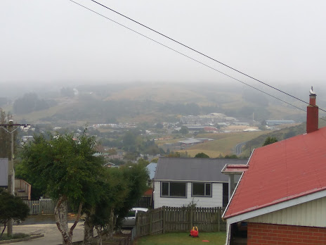
 Despite being a bit misty and rain threatening, I decided to walk some more streets today.  The views are not as good as they could have been because of the mist. I walked 12 streets today.

682. Orr Street
683. Craig Hendry Street
684. Morris Street
685. Davies Street
686. Mulford Street
687. Bell Crescent
688. Roy Crescent
689. Thoreau Street
690. Samson Road
691. Morton Street
692. Mary Street
693. Stevenson Road

Today I decided to avoid the busy city streets that I have been walking the past week and headed off to walk streets in Concord, at the other end of town. I started in Orr Street and walked up Stevenson Road to where it joins Corstorphine Road. This is where I had finished walking on Day Eighteen of my challenge. Stevenson Road is a bit unusual in that it has houses on one side and, despite being in the city, has paddocks on the other side. 

The large area of paddocks divides Corstorphine and Concord and has a 'for sale' sign so one day it might become a new subdivision for housing.  At the moment it is a nice break between the houses and the residents get a nice outlook. 

After turning off Stevenson Road, I walked part of Mulford Street and then onto Craig Hendry Street which has a large triangle of open grass at the end.  The residents of Craig Hendry Street have a good view looking over towards Corstorphine (in the mist)

If the weather had been better, the views would have been better. Despite the mist, I could still see down the hill to Kaikorai Valley where I had been walking on Day Twenty Seven of my challenge. 

I followed Mulford Street from the top of the hill down to the bottom and was rewarded with good views looking down to the Southern Motorway. Being early Saturday morning, the motorway wasn't very busy but I imagine there would be a lot of traffic noise at times. 

Rounding the corner from Mulford Street to Morton Street gives a good view of the motorway as it comes down the hill from Lookout Point.  It is a good place to see where the open farmland divides the two housing areas of Corstorphine and Concord.

As I walked back up the hill to Orr Street, where I had started my walk, I walked past the Emerson Street Reserve.  It is a large playground and sports fields surrounded by houses and it gave me a chance to look over the streets that I had walked this morning. 

There were a couple of interesting things I saw on my walk today.  The first is the Shaky Lane street sign.  It's not a legal DCC street sign but is one that the residents of the lane have put there themselves.  I am not sure why it is called Shaky Lane.  The other is the 'Beware of the Dog' sign on the letterbox, it's a neat twist on the usual beware of the dog sign. It gave me a good chuckle as I walked past. 


I walked past one painted telephone cabinet today.  It has the word 'compassion' under the cow and sheep and is not far from the Burnside Freezing Works which opened in 1883. It was one the major industrial establishments in the Green Island/Concord area until it closed in 2008. 


Distance walked:  9.8 km      Walking time   1 hr 50 mins    

Total distance: 435.8 km       Total walking  82 hr 06 mins 


Friday, February 5, 2021

Day Twenty Four Maryhill

 I am walking my way around the top of the hill and today I walked 12 streets.

288. Warwick Street
289. Wills Street
290. Renfrew Street
291. Lancefield Street
292. Oakwood Avenue
293. Bridger Street
294. Benhar Street
295. Scoular Street
296. Forbes Street
297. Mornington Road
298. Blackford Street
299. Neatherby Street

I started my walk by keeping to the top of the hill and walking Warwick Street which looks out towards Corstorphine and streets that I have walked.  Then I walked around to Oakwood Avenue which also has some very good views over the city and again I have walked most of the streets that I could see from here. 

It wasn't all on the flat as I had to walk down Lancefield Street to meet up with a street I had walked yesterday, Sydney Street.  Lancefield is a very steep, narrow street that has an interesting 'passing bay' part way up.  While the residents of Lancefield Street have a couple of very sharp corners to negotiate they are rewarded with fantastic views.  


The rest of my walk was mainly on the flatter streets along the top of the hill, with the exception of Mornington Road which I walked all the way to the Lookout Point fire station.  Mornington Road is not overly steep and it does have some semi rural views looking towards Saddle Hill.  

One of the interesting things I saw on my walk today are these neat conifer trees that have been pruned to the shape of an O.  The owner of these trees has gone to a lot of trouble to keep them well trimmed.  

On my walks I like to look out for interesting letterboxes and today I saw this 'tardis' type letter box painted in the same colours as it's house and this yellow car letter box which is very cute.  


And finally there is this bus stop beside the Raglan Street playground that is painted to fit in with it's surroundings.  

Distance walked:  7.3 km      Walking time  1 hr 26 mins    

Total distance: 200.3 km       Total walking  37 hr 10 mins


Otago Harbour Cycleway 30 October 2023

With my sister in town, it seemed a shame to waste a calm, sunny day so the two of us hopped on a bike each to enjoy the recently opened 32k...