Saturday, March 20, 2021

Day Forty Wakari

 Today I enjoyed my walk up and down the hill.  I walked 17 streets

519. Beresford Street
520. Farley Street
521. Pennant Street
522. Hastings Street
523. Gilmore Street
524. Cromwell Street
525. Broomlea Street
526. Oliver Street
527. Berwick Street
528. Ethel Street
529. Edgar Street
530. Mount Street
531. Foresbank Avenue
532. Greenhill Avenue
533. Crichton Street
534. Prospect Bank
535. Shetland Street

The first street I walked up was Beresford Street.  It took me most of the way up the hill, completing the side streets and having a rest near the top.  The view looking back down Beresford Street does not show how steep it felt when walking up. 

As I walked along Hastings Street I was able to stop and look back over parts of Dunedin that I have already walked.  It is good to think that every thing I could see from here I have already walked.


After walking most of the way up the hill, I headed back down to the bottom to complete some for streets.  I had a good view of the church in Kaikorai Valley as I walked my way around the streets towards the church.  There has been a church here since 1868 although the one standing today is the third church built in 1906 on the same site as the others before it.  

After walking past the church, I was walking back up the hill on Taieri Road. I turned off Taieri Road onto more side streets.  The walking was easy as I walked back and forth along the flat streets on the top of the hill.  The views looking out over the city are great looking as far as the harbour and the hills of the peninsula.

There was a number of things that I noticed on my walk today.  The first was this address sign for Hastings Drive which is a private driveway off Hastings Street.  And there is this very happy Otago letterbox. 


There is also this hedge that I walked around and did not notice how it had been cut until I stopped to look back at it. Someone has put quite a bit of thought and effort into cutting it. 

And finally I stopped for a look at this bus stop.  I am enjoying all the painted bus stops that I have found on my walks. I really like how they are painted to represent the communities that they are in and this one has Mount Cargill on the back wall.  You can see Mount Cargill from almost anywhere in the greater Dunedin area and I've often thought that you can never lost in Dunedin if you can see Mount Cargill.


Distance walked:  9.3 km      Walking time  1 hr 49 mins    

Total distance: 336.5 km       Total walking  63 hr 19 mins

Saturday, March 13, 2021

Day Thirty Nine Wakari

 Today I had another lovely, sunny day for walking the streets. I walked 21 streets and today is a milestone with having walked over 500 streets. 

498. Munro Street
499. Butler Street
500. Burt Street
501. Rosebank Avenue
502. Chapman Street
503. Cohen Place
504. Craighall Crescent
505. Dale Street
506. Kinsman Street
507. Mardale Street
508. Font Street
509. Wright Street
510. Walton Street
511. School Street
512. Tyne Street
513. Oban Street
514. Dunblane Street
515. Sargood Street
516. Wales Street
517. Fairfax Street
518. McMillan Street

I started my walk by going downhill then straight back up which seemed to be the theme of my walking today - down then up, back down then up again.  I walked down Lynn Street past the sports fields of Balmacewan Intermediate and then up the hill after the sports fields.

Once past Balmacewan Intermediate I was able to connect back up with Balmacewan Road where I had been walking yesterday, then it was back down Lynn Street and I was able to look back at streets I had walked recently. 

One of the benefits of walking on the hills is the views.   I am always happy to stop and look back to where I have come from (past the round about) and also to see all the streets that I still have to walk (everything behind the round about). 

I was able to join up some streets onto Kaikorai Valley Road where I had finished walking a couple of weeks ago.I have walked everything on the left of Kaikorai Valley Road but I have not walked any of the streets on the right.

Once I was onto walking Tyne Street I was able to look over to Wakari and see some of the streets I had walked earlier today but most of what I could see are streets that I have not been to yet. I also enjoyed the view of Flagstaff again.  Flagstaff is the hill behind the houses. 

The area I walked today has a number of quiet green spaces that are worth exploring further.  I passed the community garden which I will need to visit another time and the Kaikorai Reserve which has been developed into a lagoon/wetlands area.  Again I didn't have the time to stop and explore further but I will be making a return visit soon. 


I also passed the Craighall Crescent Recreation Reserve hidden on Craighall Crescent which is one of over a hundred reserves within the Dunedin City boundary.

Today I walked past Columba College which is a high school established in 1915 by the Presbyterian Church as a boarding and day school for girls.  Parts of the school date back to it's start with impressive stone buildings.


Distance walked:  10.8 km      Walking time  2 hr 2 mins    

Total distance: 327.2 km       Total walking  61 hr 30 mins

Friday, March 12, 2021

Day Thirty Eight Balmacewan

The weather and life have stopped me from getting out walking for a week and I was pleased to have blue sky today.  I walked 12 streets today

486. Dudley Place
487. Stonelaw Terrace
488. Brownville Crescent
489. Spylaw Street
490. Passmore Crescent
491. Grater Street
492. Sim Street
493. Prestwick Street
494. Pilkington Street
495. Cannington Road
496. Cairnhill Street
497. Braeview Crescent

I started by walking along Cannington Road towards Prospect Park.  It was good to get glimpses of Pine Hill from between the houses and I was really enjoying walking the streets again. 


Prestwick Street is a good street to walk along as it has great views looking towards Wakari.  I have walked none of the streets that I could see. 

I walked down (and back up) part of Balmacewan Road.  There are good views of Flagstaff (the hill in the background) from Balmacewan Road.  Flagstaff is a popular walking area and has some of the best views of the city. 

Balmacewan Road is unusual in that it dissects the Balmacewan Golf Course (at the bottom of the hill in the photo above).  Golfers need to stop playing, pick up their golf ball and clubs to cross the road to and continue playing. 

After Balmacewan Road, I walked along Pilkington Street past John McGlashan College, a state intergrated high school for boys.  John McGlashan College was opened in 1918 and is named after John McGlashan who was a Presbyterian lawyer, politician  and educationalist.  

Part of the school borders Cannington Road where I could see sports teams practicing on the school fields. 

The last street I walked today was Braeview Crescent and I was rewarded with fantastic views looking down to Leith Valley and over to Pine Hill where I am looking forward to walking more streets.

There were a few interesting parts of my walk today.  The first is this 'public art' on the side of a garage.  I am enjoying discovering all these hidden paintings around the city. 

Braeview Crescent is a hidden gem of a street with houses on both ends and in the middle is a narrow, winding street with trees closing in. 

There are gaps in the trees of Braewview Crescent and it is easy to see how the town belt curls around Ross Creek, under Pine Hill and finishing at the Dunedin Botanical Gardens.  Dunedin is very green looking from this part of the city.

Distance walked:  7.1 km      Walking time  1 hr 19 mins    

Total distance: 316.4 km       Total walking  59 hr 28 mins


Saturday, March 6, 2021

Day Thirty Seven Maori Hil

It was an interesting walk today where I walked some wide streets and also some very narrow streets.  Today I walked 12 streets.

474. Cosy Dell Road
475. Kyle Street
476. Ailsa Street
477. Lachlan Avenue
478. Highgate
479. Henry Street
480. Falkland Street
481. Lothian Street
482. Pollock Street
483. Como Street
484. Viewpark Lane
485. Chamberlain Street

I made a slight error in judgement today because I first walked down one of the paths through the town belt as I intended to start further down the hill.  Unfortunately the path I took didn't take me to the street that I thought I was going to start on and instead I ended up being further away than I had planned.  Not that it was much of a problem because I just kept walking until I got to where I was supposed to be and it also meant that I walked a few 'extra' streets.  

One of those extra streets was Kyle Street which was unusual as it was a narrow street through a tunnel of trees. I had no idea where it was taking me.  At the other end of this street was a tennis court and a few houses.  I did wonder why Kyle Street needed yellow no stopping lines as it is clearly not wide enough for anyone to park in. 

My earlier mistake through the town belt meant that I was on the outskirts of the University student flatting area and it was very obvious the difference in the state of the streets to anywhere in the city that I had already walked.  It is a shame that students seem to think that it is OK to just walk away from their rubbish. 


From Lachlan Avenue and Ailsa Street there are good views of the Dunedin Botanic Gardens which is the part with all the large green trees behind the student flats.  The Dunedin Botanic Gardens is the oldest botanic gardens in New Zealand and was established in 1963.  The botanic gardens forms the end of the town belt.

Once I started walking back up the hill, the views started to open out again and I was rewarded with a better view of the Dunedin Botanic Gardens with the University student flats in front,  Opoho behind the gardens and North East Valley to the left.  I have not walked any of these streets yet.

As I mentioned earlier there were some narrow streets that I walked today where cars needed to park half on the footpath.  One of the narrowest that I walked was View Park Lane.  It is so narrow that there is no vehicle access to the street but it has a street sign and the houses have letter boxes which means that I can count it towards my challenge of walking every street in Dunedin

And the next street over from View Park Lane is Chamberlain Street which is very wide and has a great view where as View Park Lane does not have view or a park.  I found these two streets a complete contrast to each other. 

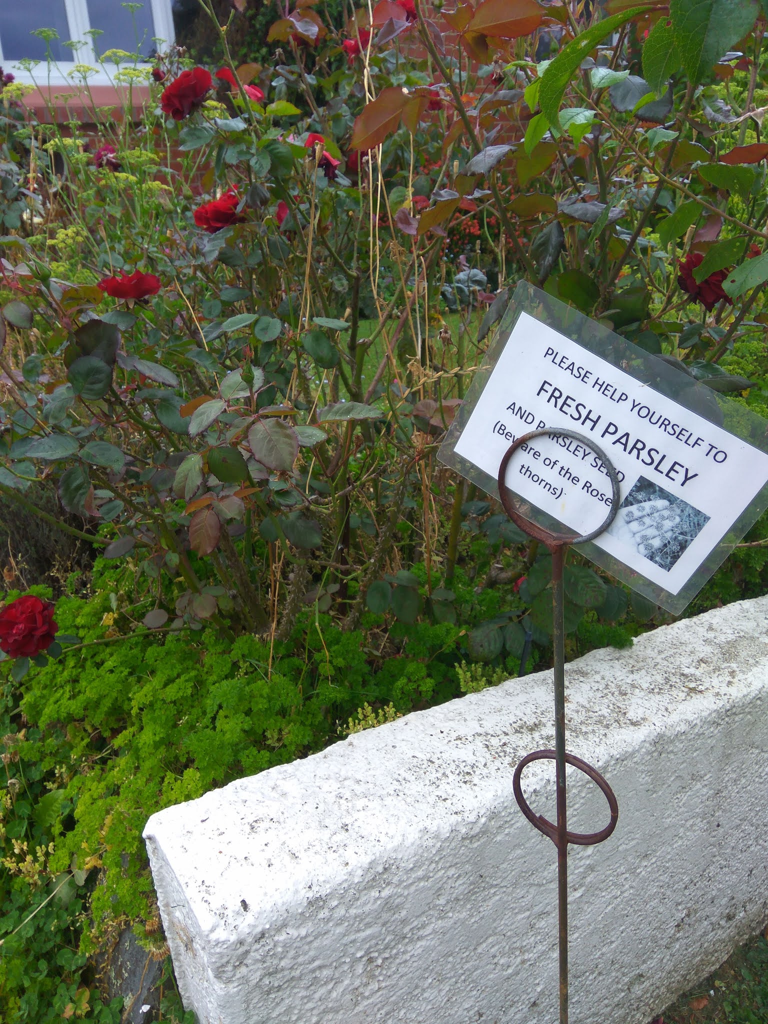
I saw quite a few interesting things on my walk today.  It is always a bonus to find friendly residents sharing the produce from their gardens and there is a lot of parsley hiding among the roses at this house.  They have also placed a seat outside their fence for people to stop and rest on while walking up the hill.  


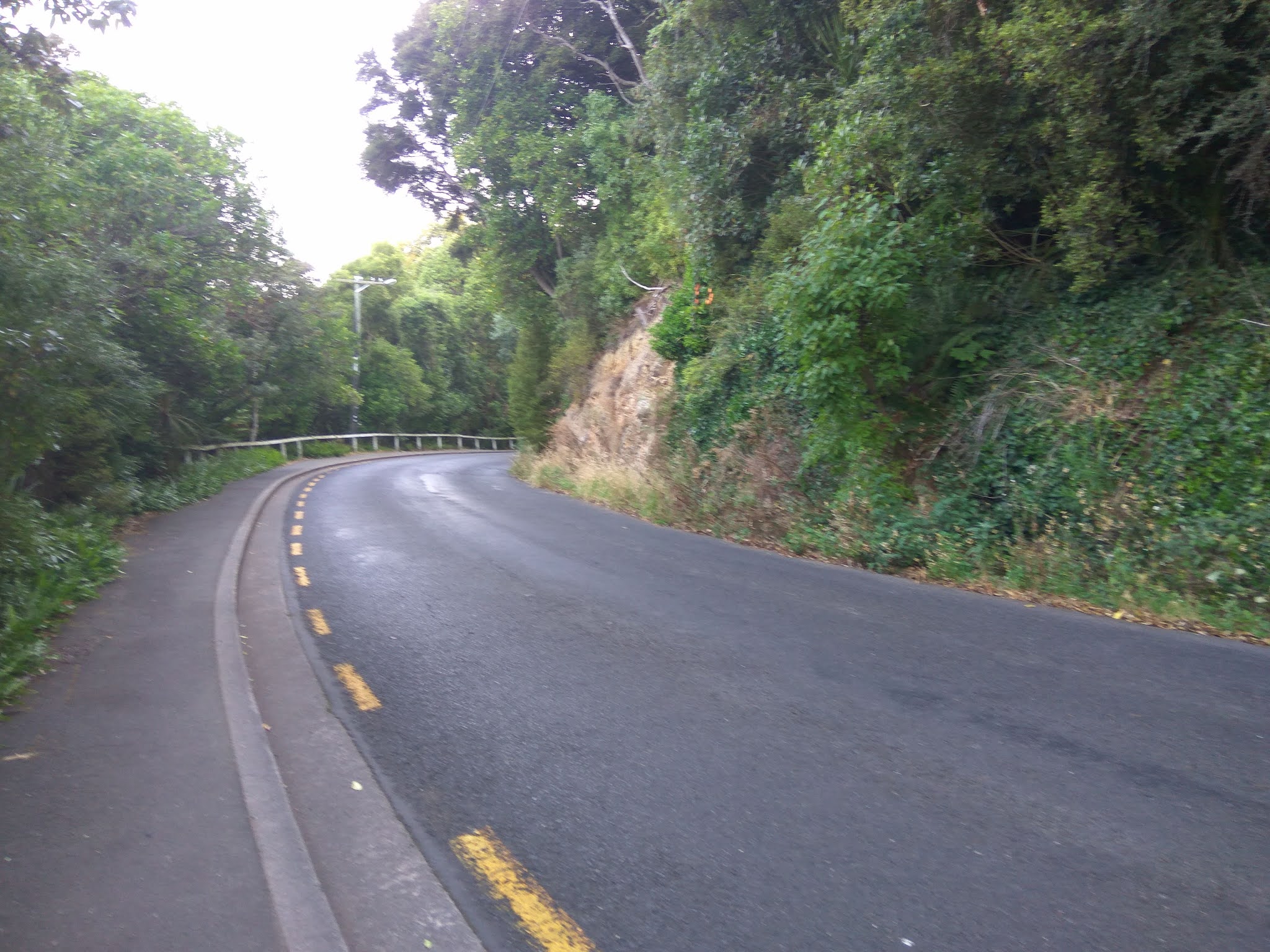
I have come across some great letterboxes during my walks and this was another one that made me stop and smile. And as I've already mentioned, there were some narrow streets and there were some wide streets and there are also some pretty streets with trees bordering the edge.  I particularly liked these trees as there were lots of leaves for me to kick as I walked up the hill.

Finally I'll share this photo taken in View Park Lane.  It seemed a bit strange to have two street signs in the one street, obviously the houses on one side have a street frontage on Chamberlain Street but does that mean they also have two letterboxes? 


Distance walked:  5.9 km      Walking time  1 hr 14 mins    

Total distance: 309.3 km       Total walking  58 hr 09 mins


Thursday, March 4, 2021

Day Thirty Six Maori Hill

 I enjoyed my walk winding around the streets of Maori Hill and I walked 12 streets today.

462. Claremont Street
463. Maheno Street
464. Hamel Street
465. Lynwood Avenue
466. Wallace Street
467. Newington Avenue
468. Burwood Avenue
469. Grendon Street
470. Brent Street
471. Baxter Street
472. Tolcarne Avenue
473. Drivers Road 
 
Today I continued to walk the streets skirting the edge of the town belt and joining onto Highgate.  This meant some hills to walk up and down but not as steep as my last walk.  The views from Maheno Street were worth a stop.  

I have really enjoyed walking around the town belt area as the streets are much quieter and it is hard to believe that I am in the middle of the city.  Newington Avenue is one of those quiet, green streets.  

Tolcarne Street is a street with a seat overlooking an uninterrupted view of the city.  I spent quite a bit of time here looking at the wonderful view of the city with the town belt in the foreground. 

The final street I walked today was Drivers Road which crosses the town belt. I walked down to where Drivers Road joined Queens Drive then I walked back up to Highgate.  Drivers Road can be very busy with traffic at times but today it was reasonably quiet.  

 I saw a couple of interesting things I saw today, one was this neat painting of two animals on a residential fence

I walked past this lovely gate on Drivers Road.  Behind the gate is a large house built in 1935.  

On my walk today I passed the Highgate Presbyterian Church.  Like so many older buildings and in particular, churches, the Highgate Church is closed to the public including church meetings due to safety questions around the building's structure. 


Distance walked:  6.6 km      Walking time  1 hr 14 mins    

Total distance: 303.4 km       Total walking  56 hr 55 mins


Tuesday, March 2, 2021

Day Thirty Five Roslyn

 Today I had a good workout by walking some steep streets in Roslyn.  I walked 9 streets. 

453. Selkirk Street
454. Littlebourne Road
455. Melrose Street
456. Avon Street
457. Tweed Street
458. Fifield Street
459. Garfield Avenue
460. Pacific Street
461. Merlin Street

The first street I walked was down the hill on Selkirk Street and onto Littlebourne Road whose residents get a good view of the harbour.  It was great to realise that I had walked all the streets that I could see on the other side of the harbour. 

From Littlebourne Road, I followed the streets that skirted around the edge of the town belt where I had walked a couple of days ago.  These streets are quite steep and I had to walk up and down them but they also have some great views  looking towards the end of the harbour. .

One of the benefits of walking on the hills are the fantastic views and I am enjoying seeing Dunedin from different angles as I move around the city. 

 Of course what goes down must also go up and Pacific Street was one of the streets I walked up.  It is a particularly steep street with steps and a hand rail on both sides.  I was very glad to get to the top. 

Something interesting I saw on my walk today was this neat police phone box letter box.  It is quite large and would hold a lot of mail.

And lastly this is the map showing where I have walked so far in my challenge to walk every street in Dunedin.  I have walked all the streets coloured in red. 

Distance walked:  5.6 km      Walking time  1 hr 05 mins    

Total distance: 296.8 km       Total walking  55 hr 41 mins

Otago Harbour Cycleway 30 October 2023

With my sister in town, it seemed a shame to waste a calm, sunny day so the two of us hopped on a bike each to enjoy the recently opened 32k...