Friday, November 12, 2021

Day 112 Sawyers Bay

My intention tonight was to walk most of Sawyers Bay and as it was such a nice night for walking, I kept walking until I had walked all of the streets in Sawyers Bay.  I walked 19 streets.

1513. Brick Hill Road
1514. Bells Road
1515. Stevenson Avenue
1516. Hall Road
1517. Springdon Avenue
1518. Delphic Street
1519. Kaira Street
1520. Fairview Terrace
1521. Tewsley Street
1522. Hugh Street
1523. Glendermid Close
1524. Mill Street
1525. Blackman Avenue
1526. Reservoir Road
1527. Constant Street
1528. Station Road
1529. Rohais Place
1530. Duke Street
1531. Freyberg Avenue

I started my walk by walking up Brick Hill Road.  This part of the street had slipped away after heavy rain in July 2018.  The road was closed for a number of months for extensive repairs. 

I enjoyed the rural views as I walked up the hill towards the houses at the top.  At one stage I watched a sheep in the paddock chase a rabbit for a short distance.

I was rewarded for my effort of walking up the hill, with some great views looking towards Port Chalmers where I will be walking next. 

These houses have some great views and I can imagine the residents would have been very happy when the large trees were cut down in front of their homes.  It has certainly opened the view up.

Sawyers Bay has hills on three sides which gives it a nice rural view.  There is a walking track that heads up the hill to the Organ Pipes and Mt Cargill. 

 Sawyers Bay is a nice mix of rural farmland and houses.  Sawyers Bay has a variety of views from farmland, harbour and hills.  It is a very pretty suburb.

I walked past this private cemetery in amongst the houses of Sawyers Bay.  The head stone is for the McDermid family.  Originally from Glasgow, Hugh McDermid and his wife settled in Sawyers Bay in 1849 and set up a sawmill.  Hugh went on to help set up the Port Chalmers School and Port Chalmers Presbyterian Church. 

I saw only one interesting letterbox during my walk today and it was extremely well done.  I really liked this tractor letterbox. 

 The map below shows Sawyers Bay and where I have walked is highlighted in red.
 
 
Distance walked:  9.1 km         Walking time  1 hr 45 mins   
 
Total distance: 932.7  km          Total walking  173 hr 58 mins 

Sunday, November 7, 2021

Day 111 Kinmont Park

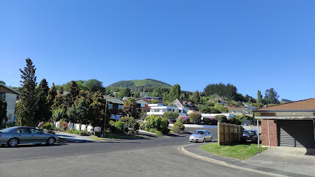
The sun was shining and the temperatures were very warm as I walked the streets in Kinmont Park today where I walked 16 streets.

1497. Riccarton Road East
1498. Cuddie Close
1499. Elizabeth Avenue
1500. Orchard Gove
1501. Jaffray Drive
1502. Fairmile Drive
1503. Braeside
1504. Clyde Street
1505. Leith Street
1506. Gebbie Street
1507. Kinmont Crescent
1508. Quarry Road
1509. Woodland Avenue
1510. Boundary Road
1511. Dee Street
1512. Tweed Street

The weather was shaping up to be quite hot so I was out walking early in the morning to beat the heat.  I walked the few streets in East Taieri before walking the streets in Kinmont Park.
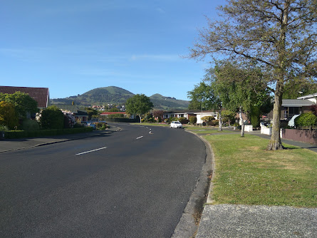
It was in East Taieri that I had one of my last views of Saddle Hill before moving onto other areas of Dunedin that I haven't walked. 

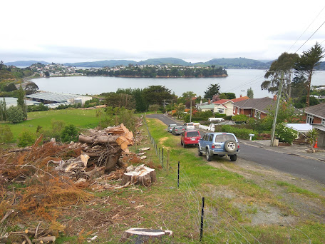
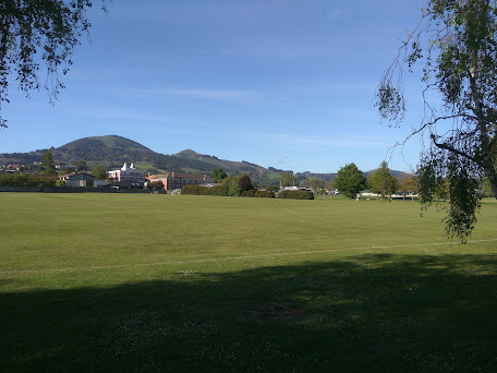
Kinmont Park is on a hill that overlooks part of Mosgiel and it was here, that I was finally able to see over Mosgiel where I have been walking for the last 10 days. After the flat streets of Mosgiel, it was great to be walking on the hills again.

 
 As I walked around the streets in Kinmont Park, I was rewarded with a view in another direction, looking towards East Taieri and Maungatua.

And then I was at the bottom of the hill, looking back up to where I had been walking.  Kinmont Park is on the lower slopes of Saddle Hill and I was able to see the rounded back of Saddle Hill at the top.  

My next destination was to the streets below the Mosgiel sign.  Each letter  of the Mosgiel sign is 3m tall and was put up by the local Rotary club in1987.  The sign is visible by the traffic as it travels past on State Highway 1.

Before reaching the Mosgiel sign, I walked the bridge over State Highway 1.  This is the main road that travels the length of the country and, at times, can be very busy.  Early on a Sunday morning is not one of those busy times.

From the bridge over the motorway I was able to see all the streets that I had walked in Kinmont Park. 

Once over the bridge, I walked a street that bordered an area where I had walked a few days ago where there is a subdivision with new houses being built.
 
Then all I had to do was cross the bridge again and walk up the hill,taking a street that was on the edge of the suburb with houses on one side and peaceful green fields with sheep on the other. 

An interesting part  of my walk today was along the street at the base of the hill that the Mosgiel sign is on.  Sometimes called Mollywood after the famous Hollywood sign, the sign has been here for 35 years and is lit up at night.

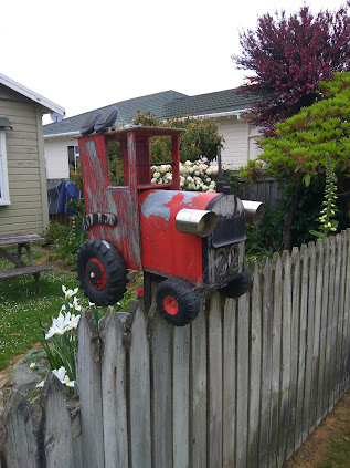
I walked past two letterboxes of interest today.  I really liked the tall house letterbox and I thought the number 7 was great too.
Distance walked:  12.2 km         Walking time  2 hr 12 mins   
 
Total distance: 923.6  km          Total walking  172 hr 13 mins 

Saturday, November 6, 2021

Day 110 Mosgiel

My plan today was that if I have a longer walk, I would be able  to finish walking the streets of Mosgiel.  I walked 27 streets today.

1470. High Street
1471. Green Street
1472. Victoria Street
1473. Wickliffe Street
1474. Tudor Lane
1475. Kent Place
1476. Windsor Place
1477. Haggart Alexander Drive
1478. Balmoral Avenue
1479. Owhiro Avenue
1480. Glenimire Close
1481. Tuwhare Lane
1482. Beech Street
1483. Cedar Crescent
1484. Oak Place
1485. Elmwood Drive
1486. Ash Place
1487 Cornish Lane
1488. Doon Street
1489. Spey Street
1490. Dunbar Place
1491. Gretna Place
1492. Arran Street
1493. Lomond Place
1494. Kelso Place
1495. Glenbrook Drive
1496. Glenleigh Place

I have become used to seeing Saddle Hill from this angle and today is the last day of walking streets that I will Saddle Hill from this angle as my goal for the day is to finish walking the streets of Mosgiel. 

I walked a mixture of streets of long, straight streets and shorter, curved streets.  The long, straight streets were wide and tended to have older houses

While the shorter, curved streets had newer houses and tended to have more trees and grass verges. 

 
Most of the streets I walked today had a view of Saddle Hill.  I have enjoyed seeing Saddle Hill, occasionally it has been covered in cloud although mostly, like today, I have had an excellent view of it.

 
Some of the newer subdivisions have a view of the Chain Hills and have lots of landscaping on the surrounding streets which makes them very enjoyable streets to walk though.

I walked past a number of playgrounds and sports fields today.  Mosgiel has a lot of playgrounds and sports fields and it has been great when I have come across these open, green spaces as it has given me the opportunity to see something other than streets and houses.  

Today I walked past Taieri College.  Taieri College started in 1871 when it was known as Mosgiel District High School and by 1882, there were over 170 students at the high school. In 2004, the high school merged with Mosgiel Intermediate to become Taieri College and now has over 1200 students. This year is the schools 150th anniversary.

 
I walked past some interesting letterboxes today.  I really liked the one painted with New Zealand's native birds and I thought the one with the 'person' leaning on the letterbox was clever.

 And finally, after 10 days and 93.5km of walking, I have completed walking the streets of Mosgiel.

 Distance walked:  13.2 km         Walking time  2 hr 16 mins  

Total distance: 911.4  km          Total walking  170 hr 01 mins 

Friday, November 5, 2021

Day 109 Highland Park

 Another day that I am walking streets in Mosgiel and I walked 14 streets today.

1456. Factory Road
1457. Wingatui Road
1458. Ben Lomand Drive
1459. Dundee Road
1460. Kinloch Place
1461. Ayshire Drive
1462. Windermere Drive
1463. Carnoustie Lane
1464. Thornley Park Avenue
1465. Lochinvar Street
1466. Smiley Place
1467. Carrick Place
1468. Stratton Way
1469. Armadale Street

I started my walk today on one of the long, straight roads that borders the edge of Mosgiel.  On one side is farmland and the other is densely built houses.    
Then I was into walking the streets of another new area of Mosgiel.  The township of Mosgiel has certainly grown over the last few years as farmland has been subdivided and new houses built.
The new streets are nicely planted with trees and grass verges.  This area of Mosgiel has large houses built on small sections with all the lawns nicely mowed.

There are some lovely green spaces built into the new areas and I have enjoyed walking in this part of Mosgiel.

One thing I noticed about the houses in this new area of Mosgiel.  The letterboxes are solidly built and have been built from the same materials as the houses. 


This map shows the streets I have walked in Mosgiel highlighted in red.  There is a part in the middle that I will be walking next.

Distance walked:  7.4 km         Walking time  1 hr 20 mins   
 
Total distance: 898.2  km          Total walking  167 hr 45 mins 

Thursday, November 4, 2021

Day 108 Mosgiel

 Today I was walking in a part of Mosgiel with newer houses and I walked 13 streets

1443. Thames Street
1444. Severn Street
1445. Centre Street
1446. Silver Springs Boulevard
1447. Anderton Crescent
1448. Marjorie Lane
1449. Melley Mews
1450. Showgate Crescent
1451. Copperfield Close
1452. Didham Drive
1453. Caledonia Drive
1454. Cavan Place
1455. Rutherford Road

Back in Mosgiel and I was walking some of the straight streets again.  One thing that I have noticed about the streets that I have been walking lately is that they have been wide with plenty of parking.
And when I walked through the area with new houses, the streets were shorter and curved more with Saddle Hill dominating the view.

The streets in the newer part of Mosgiel are pretty with plenty of green trees and grass.  It is a much more interesting area to walk in than the long, straight streets of that I have been walking over the last few days.

 
I walked over Silver Stream which I have been walking near for a few days now.  Part of Mosgiel runs along beside Silver Stream with a walkway running between the houses and the stream.
Looking the other way, Silver Stream looks peaceful as it emerges from the trees.  Silver Stream runs for 30km  from the southern slopes of the Silver Peaks.
Bordering on the edge of Mosgiel is the Taieri Aerodrome which was once the most southerly Royal New Zealand Air Force flying station during World War II and is now home to the Otago Aero Club.  The Otago Aero Club is the oldest aero club in New Zealand, dating back to 1927.  The Aerodrome is also the home base for the Otago Rescue Helicopter.
Some of the cul-de-sacs in this area are planted with trees and have tables where the residents can meet up in the evenings.
 
I walked past this unusual letterbox today.  It is quite apt being beside a private street called Aviation Lane and very close to the Taieri Aerodrome.


Distance walked:  7.5 km         Walking time  1 hr 19 mins   
 
Total distance: 890.8  km          Total walking  166 hr 25 mins 
 

Otago Harbour Cycleway 30 October 2023

With my sister in town, it seemed a shame to waste a calm, sunny day so the two of us hopped on a bike each to enjoy the recently opened 32k...