Saturday, October 16, 2021

Day Ninety Eight Allanton, Momona & Outram

Today I decided to walk the streets of another three suburbs on the outskirts of the city.  I walked 29 streets today.

1297. Peel Street
1298. Ralston Street
1299. Grey Street
1300. Bardsey Street
1301. Precelly Street
1302. Ramsey Street
1303. Snowdon Street
1304. Caernarvon Street
1305. Hay Street
1306. Douglas Street
1307. Stack Street
1308. Castleton Street
1309. Ward Street
1310. Trigg Street
1311. Trent Street
1312. Holyhead Street
1313. Mountfort Street
1314. Franks Place
1315. Bidston Street
1316. Orme Street
1317. Railway Lane
1318. Bell Street
1319. Beaumaris Street
1320. Formby Street
1321. Rodeo Place
1322. Three Kings Court
1323. Lynas Street
1324. Skerries Street
1325. Hoylake Street

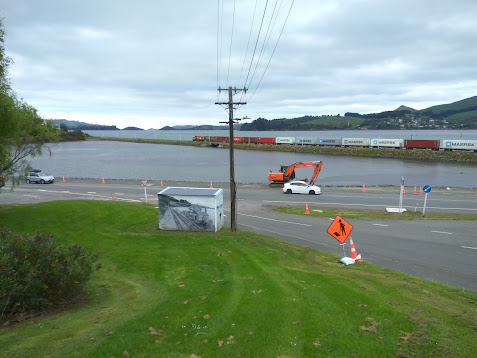
I started walking the streets in Allanton today which is a small township at the turnoff to the Dunedin Airport from State Highway One. I was surprised at the number of small hills that I walked up and down in Allanton

 
I have driven past Allanton many times but I had never walked it's streets before today and I found it be a pretty township with lots of green trees and shrubs. 
While there are quite a few houses in Allanton, there are paddocks alongside most houses which seem to have a few sheep or other farm animals. 
After walking the streets in Allanton, I moved onto the streets of Momona.  Momona is a small township on the edge of the Dunedin Airport and built on airport land.  There are three streets in Momona and they are all named after RNZAF airmen who received the Victoria Cross

The streets of Outram are wide, straight and flat with the hill of Maungatua behind it.  The name Maungatua is Maori and means 'Hill of the Spirits'.  

There is a lot of flat farmland surrounding Outram and the township is growing with new streets and new houses being built.  Today I walked a number of these new streets.
 
The streets of Outram run in a grid and I found that I needed to keep track of which streets that I had walked or I would miss completing some of them.  With the township being flat about the only hill I could see was Maungatua which dominated the view South.   

As Outram is close to the Taieri River, along one side runs the floodbank which protects the township when the river floods. Built around 1986, access to the floodbank is from the ends of some of the streets.
While there is no vehicle access on the floodbank, there is a walking track that is a popular walk, taking in farmland on one side and houses on the other. 

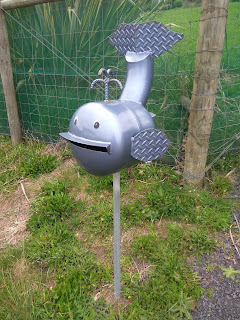
I walked past some interesting letterboxes today.  My favourite of the day is the Minion which is as large as a child. 


I saw quite few different animals during my walk today.  Apart from disturbing lots of dogs, I saw horses, sheep, a goat, pigs and two alpacas.


Distance walked:  14.5 km         Walking time  2 hr 47 mins   
 
Total distance: 810.8 km          Total walking  152 hr 07 mins 

Friday, October 15, 2021

Day Ninety Seven St Leonards

The weather has kept me from walking over the past week or so but I was able to get back out again today.  I walked 11 streets.

1286. Kea Street
1287. Finch Street
1288. Burkes Drive
1289. Moa Street
1290. Kaka Road
1291. Korimako Street
1292. Kiwi Street
1293. Huia Street
1294. Gannet Lane
1295. Hawk Lane
1296. Harrier Road

Tonight I walked along the road from Maia to St Leonards which used to be the main road to Port Chalmers.  Built in the 1860's this road connected Port Chalmers to Dunedin.
 
The railway line between Dunedin and Port Chalmers was built in the 1870's and as the township of Port Chalmers grew the faster harbourside road was built in 1965.
As I walked along the side of the harbour, I was rewarded with fantastic views looking across to the hills of the peninsula and Macandrew Bay
 
A lot of the houses in St Leonards are rewarded with great views looking down the mouth of the harbour and Harbour Cone which is the triangle shaped hill on the right. 
My walk tonight wasn't just along the flat as there are a number of steep streets in St Leonards that I walked up.  My reward for walking up the steep streets was getting a good view of Harbour Cone and the hills of peninsula as I walked back down.
During my walk tonight, I saw a train on it's way to Port Chalmers.  There has been a cycle/walkway has been built along the side of the railway line.  

Along the side of the Burkes Drive are the Halo Project traps.  I have walked past these traps in other parts of the city and each time I am reminded of what a great job these traps and the people who check them are doing to protect in helping to make predator free. 

Distance walked:  7.1 km         Walking time  1 hr 24 mins   
 
Total distance: 796.3 km          Total walking  149 hr 20 mins 

Sunday, October 3, 2021

Day Ninety Six Waldronville

Since I had finished walking the streets of Waikouaiti yesterday,  I headed south to walk the streets of Waldronville.  I walked 13 streets today.

1273. Craddock Place
1274. Friendship Drive
1275. Viscount Road
1276. Vulcan Road
1277. Lancaster Lane
1278. Delta Drive
1279. Valiant Road
1280. Vampire Road
1281. Dakota Place
1282. Canberra Place
1283. Wavy Knowes Drive
1284. Brighton Road Waldronville Section
1285. Kilmanock Close

Waldronville is close to where I was walking a few weeks ago when I walked the streets of Green Island.  The streets of Waldronville all run off on the left of the main road through the suburb. Waldronville is close to the sea and I could hear the waves during my walk of the streets today.

The streets of Waldronville are not the most interesting streets to walk as they are flat and laid out in a grid.  This meant that I needed to walk a lot of the streets twice in order to ensure I didn't miss any sections.

There are some walkways through to the beach behind the suburb.  This gives the residents easy access to the beach and good exercise areas for dog walkers and mountain bikers. 

The last street I walked was Wavy Knowes Drive which is on a small hill overlooking the Island Park Golf Course and Kaikorai Lagoon.
 
Most of the streets of Waldronville were built in the 1950's and are named after World War 2 fighter aircraft.  This is shown in a playground located off Delta Drive where a replica of a plane has been combined into the playground equipment

 
I walked past some interesting letter boxes today.  I am guessing the snorkeling and whale letterboxes are because Waldronville is close to the sea and the cow because some of the houses have a rural outlook.

The other interesting thing I noticed about the letterboxes are that all the letterboxes in Lancaster Lane all have the same letterboxes.  This street is a new subdivision that has been built on the old Waldronville School site.

One of the bus stops that I walked past today was painted with World War 2 fighter plane scenes which reflects the street names. 

 And below is a map of the streets of Waldronville that I walked today.  The streets that I walked are highlighted in red.

 
Distance walked:  7.9 km         Walking time  1 hr 29 mins   
 
Total distance: 789.2 km          Total walking  147 hr 56 mins 

Saturday, October 2, 2021

Day Ninety Five Waikouaiti

Today I headed back to finish walking the streets of Waikouaiti and I walked 18 streets.

1255. Inverary Street
1256. Nairn Street
1257. Dumbarton Street
1258. Haddington Street
1259. Inverness Street
1260. Greenlaw Street
1261. Matanaka Road
1262. Rothesay Street
1263. Cromarty Street
1264. Perth Street
1265. Clackmann Street
1266. Cupar Street
1267. Forfar Street
1268. Edinburgh Street
1269. Glasgow Street
1270. Gill Street
1271. Victoria Street
1272. Main Road

In Waikouaiti today, I was walking the streets on the other side of the lagoon and race course.  These streets are more rural and are similar to other streets in Waikouaiti as some are long and straight.
These roads skirt around the furthest edge of the Hawksbury Lagoon.  This is the lagoon that I had been walking on the other side during last weekend's walk. 
 
As happened last weekend I eventually walked all the way to the beach.  This beach is 4km in length and is the landing place of  'The Magnet' in 1840 . 

There were only a few people at the beach today and I was lucky to see this horse being exercised on the beach by it's jockey.
 
I walked past the golf club at Waikouaiti.  This is a small golf course with only 9 holes and was started in 1935. Because the course has a sand based surface, golf can be played all year round, regardless of the weather. 
 
After the golf course, I walked past the race course.  I had seen the race course from a different angle last weekend and I remember coming here with my family when I was a child.  The race course no longer has any meetings and is looking run down, especially the grandstand.
One of the last things I walked under while on my way back to where I started is this war memorial arch built over the footpath by Post Office Creek.  This memorial has 41 names on it of people from the area who did not come home from war. 
 
On my walk today, I walked past another entrance to the Hawksbury Lagoon.  I have enjoyed seeing the lagoon from different angles and I would like to come back and explore it further.
I was surprised to walk past this sheep and her lambs as the sheep had literally given birth to the two lambs minutes before I arrived.  I watched as the lambs stood for the first time and then took their first steps to their mother for feeding.
 
Walking on the rural side of town today, I walked past many animals.  A lot of houses had horses and sheep with a few cows and the odd pig as well.  These friendly horses were grazing on the side of the road.
 
And lastly, I have included the map of the streets that I have walked in Waikouaiti.  The streets that I completed today are on the right near the racecourse and towards the beach.  The other streets I walked over two days last weekend.

Distance walked:  9.8 km         Walking time  1 hr 49 mins   
 
Total distance: 781.3 km          Total walking  146 hr 27 mins 

Friday, October 1, 2021

Day Ninety Four Maia

With daylight savings and spring, the days are getting longer which means I can walk more in the evening.  Today I walked 9 streets.

1246. Manapouri Street
1247. Ascog Road
1248. Ravensbourne Road
1249. Rotoiti Street
1250. Fern Road
1251. Isabel Street
1252. Babsie Road
1253. Jesse Street
1254. De Lacy Street

As I was walking in the evening, after work today, I headed back to Ravensbourne where I had been walking last week and walked the streets of the neighbouring suburb of Maia. The streets in Maia are just as steep as Ravensbourne. 
 
And as I have seen throughout my walking the streets of Dunedin, walking the streets on the hills means great views. The residents of these houses get great views looking across the harbour to the hills of the peninsula.
 
After walking the steep streets to the bottom, I chose to walk up the streets that wound their way up the hill.  It was still the same height gain but it was much easier walking, although the streets are still very narrow.
 
At the top, I came across a new street which is part of a new subdivision.  The houses that are being built in this new street are all going to have fantastic views looking up the harbour. 
 
Having already walked down the hill and back up, I then walked down Jesse Street which must rival Baldwin Street for the steepest street title. Jesse Street is only one way for down hill traffic.
 
And once at the bottom, I had to walk back up the hill (for the second time tonight).  Like the last time, I walked up a street that was less steep and wound it's way up the hill. 

 
The painted bus stop at Maia is painted with a harbour view and native birds often seen in the area.


Distance walked:  5.3 km         Walking time  1 hr 3 mins   
 
Total distance: 771.5 km          Total walking  144 hr 38 mins 

Otago Harbour Cycleway 30 October 2023

With my sister in town, it seemed a shame to waste a calm, sunny day so the two of us hopped on a bike each to enjoy the recently opened 32k...