Saturday, June 5, 2021

Day Sixty Four Green Island

 Today was a lovely warm winters day, perfect to be out walking the streets again and I walked 10 streets today.

781. Irmo Street
782. Bideford Street
783. Orange Street
784. Price Street
785. Owen Street
786. Kaler Street
787. Koremata Street
788. Winifred Street
789. Prosser Street
790. Shanks Street
 
 I started my walk on the side of the Southern Motorway which is a good place for an early morning view looking towards Saddle Hill and Green Island, which is where my walk was taking me today. 

As I walked down the hill towards Green Island, I skirted around the edge of Concord where I had been walking a few weeks ago.  It is quite satisfying knowing that I have already walked all the streets on the hill. It is also interesting to have paddocks with sheep and cows in the city, on the edge of the motorway.

Once I reached the bottom of the hill, I was walking along Main South Road and up all the side streets.  The traffic noise is quite noticeable down in the valley. I was able to look back up the hill to where I had started my walk.

I walked some very short streets with only a few houses and others that are longer and steeper.  Koremata  Street is one of the longer streets and has a good view looking towards farmland on the hill opposite and Flagstaff in the distance.  I had been walking the streets at the base of Flagstaff only a few days ago.

Owen Street was one of the steeper streets and it had a short street off it that finished because the hill was too steep for it to carry on and there is a gap between Kaler Street and Shanks Street, at the bottom which is good for me as I got to count them as two separate streets.

One of the more unusual things I saw today on my walk was Spongebob Squarepants up a tree.  I don't know how Spongebob got to the top of the tree but he is looking very happy. 


I walked past a couple of interesting letterbox on my walk. One is this speedy looking bee and the other is an old milk urn.

And finally there is this great library.  I have passed quite a few Lilliput Library's during my walking every street but this is the first large size one I have come across.  There were quite a few books in the library.


Distance walked:  8  km         Walking time   1 hr 35 mins     
 
Total distance: 512.1 km       Total walking  95 hr 50 mins


Sunday, May 23, 2021

Day Sixty Three Kensington

For a number of reasons, it's been a few weeks since I have been able to get out walking so I was very happy today to be able to walk 9 streets. 

772. Ardmore Drive
773. Grosvenor Street
774. Phillips Street
775. Percy Street
776. Wain Street
777. Orari Street
778. Strathallan Street
779. Kensington Street
780. Bridgman Street

Being late Autumn, the sun rises later and I was rewarded with a beautiful start to my walk when I completed the streets around the Oval.  

I had last walked around part of the Oval back in early April so it was nice to be able to walk the remaining streets to complete the circuit.  The Oval was frosty with mist rising from the cold ground during my early morning walk. 

Today I was walking the semi-industrial streets on the flat of South Dunedin so there weren't many views so I was happy to walk the streets that were connected to the harbour.  This morning the harbour was calm with  Flagstaff and Mount Cargill looming in the background. 

While there were not many views on my walk today, there was still lots to see. One of the more iconic things I have walked past on my walks is Victor, the VW beetle up the pole outside the Bridgman Street Panelbeaters.  Victor has been up the pole since 1965. 

Another point of interest on my walk today was the Molars.  Located on Portsmouth Drive, the molars have been in place since 2010 and are inspired by the Dental School and are supposed to represent the teeth at the back of the (harbour) mouth. The molars are about 6 feet high and made out of Oamaru stone. 


One of the benefits of walking early in the morning when the sun rises is having the time to notice the beauty around me.  This tree on the edge of the Oval is particularly photogenic with the rising sun shining behind it. 
 
I also walked past a couple of interesting buildings.  One of the older buildings that I walked past is the Mayfair Theatre.  Originally called the King Edward Picture Theatre it was opened in 1914 and is the oldest surviving purpose built theatre in Dunedin and the third oldest in New Zealand.  Modernised in 1934 and renamed the Mayfair Theatre it was gifted to the community in 2014.  It continues to operate as a theatre for live performances to this day. 

Near the Mayfair Theatre is the Hillside Workshops which have operated from this site since 1875 and over the years, it has made steam engines, wagons and rail carriages.  Employing over 800 people in the 1920's it is now a shadow of it's former self  with most work carried out here, being locomotive and wagon maintenance.  

And finally for the buildings, I walked past this building on the corner of Hillside Road and King Edward Street.  It caught my eye because it has a lovely restored facade but it looks like part of the building is missing.

On the final street that I walked today, I walked past this interesting fence that has been made using power poles that still have their arms and insulators attached. 

Distance walked:  6.4 km      Walking time   1 hr 9 mins     
 
Total distance: 504.1 km       Total walking  94 hr 15 mins

Sunday, May 2, 2021

Day Sixty Two Glenleith

Today I enjoyed walking in the quieter streets with all the autumn colours.  I walked 11 streets

761. Malvern Street
762. Harden Street
763. Islay Street
764. Andail Street
765. Fulton Road
766. Glenmore Street
767. Glenholm Street
768. Tanner Road
769. Garden Place
770. Hadley Close
771. Leithton Close
 
 My walk today started beside the Water of Leith.  It is a picturesque river surrounded by trees with a lot of bird life.  While I didn't see many of the birds, I could hear them often.
 

Malvern Street crosses the Leith a couple of times with houses on one side and the Water of Leith on the other side.  Malvern Street took me to the bottom of Flagstaff (the hill at the end of the street in the picture below).  I have been able to see Flagstaff from many parts of the city and have slowly been walking my way towards it. 

It was nice to walk up the hill as the views started to open up and I was able look towards the Northern Motorway and bush surrounding the northern end of Dunedin. 

Once I reached the top of the hill, I was able to follow the streets along the top of the ridge.  There were openings between the houses which gave me great views looking towards Pine Hill and the hills of Opoho in the background. 

Being on the top of the ridge also gave me a good view looking the other way at Flagstaff.  There is a popular walking track to the top of Flagstaff that starts just around the corner in the photo. 

And the final views I had for the day before walking down the hill, back to the Water of Leith, were looking towards the houses at the top of Pine Hill.  I have not walked the streets that I can see from here.

 
The last part of Tanner Road is a narrow, winding road that is only one way for downhill traffic.  It is quite picturesque at this time of year but I am pleased it is only one way because it is so narrow. 
On my walk today I passed this painted telephone cabinet.  The cabinet sits beside the Water of Leith and fits into it's surroundings beautifully as it is painted to represent the Water of Leith both in and above the water.  I have seen many painted telephone cabinets on during my walking every street in Dunedin and this is one of my favourite so far. 

Just across the road from the telephone cabinet is this bus stop that is painted with the birds of the area.  I heard the call of the Tui (as painted on the bus shelter) during my walk today.

One of the more unusual streets that I have walked is Andail Street.  Many years ago, part of the road slipped away and has never been fixed.  I am guessing that since Andail Street is a short street and the slip is after the last house the council thought the cost of repair wasn't worth it.  You can drive into both ends but the section that has slipped is only a walking track.

Today I walked past Craigieburn was a farm settled in 1860 by the Rankins whose daughter, Elizabeth Rankin lived on the site until her death in 1949 at the age of 93.  The farm is of significance due to having the Ross Creek Reservoir and untouched native bush.  The property with the resevior and bush was purchased for the people of Dunedin after the death of Elizabeth Rankin. 

I walked past two letterboxes worthy of a mention today.  Bothlook like they represent the kea with one being a painted letterbox and the other is metal representation. 


Distance walked:  8.6 km      Walking time   1 hr 38 mins     
 
Total distance: 497.6 km       Total walking  93 hr 06 mins

Saturday, May 1, 2021

Day Sixy One North Dunedin

I enjoyed the lovely sunny, Autumn morning today by finishing walking around the Unversity and student housing area.   I walked 13 streets

748. Butts Road
749. Logan Park Drive
750. Anzac Avenue
751. Minerva Street
752. Parry Street West
753. Forth Street
754. Leithbank
755. Union Street East
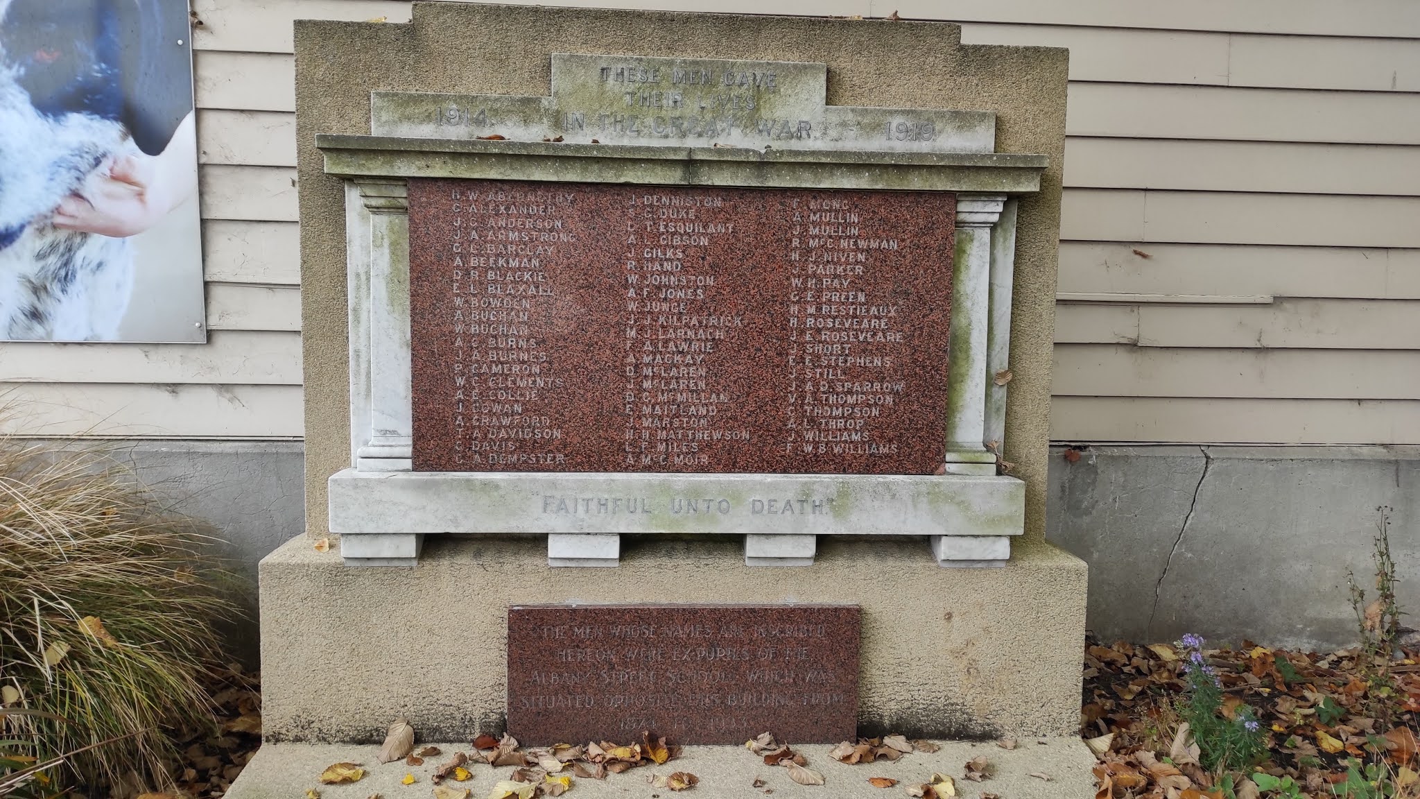
756. St David Street
757. Harbour Terrace
758. Agnew Street
759. Clyde Street
760. Trent Avenue
 
I started walking along Butts Road which runs around the outside of the University Oval.  Butts Road runs around the base of the hill that circled Lake Logan.  In 1913 reclamation of the lake began and the land became the site for the 1925 South Seas Exhibition.  The road today has large trees and is quite picturesque in the spring and autumn.  
 
The University Oval is a series of sports grounds including the Caledonian track and field grounds, Otago Cricket test cricket ground,Otago Rugby Football training grounds, hockey turf, soccer fields and tennis courts.  Once owned by the University of Otago the fields are now owned by the Dunedin City Council.  

As I continued walking around the Unversity Oval, I was able to get some good views looking  towards Flagstaff with local teams practicing on the sports fields.  Being next the Unversity, there are student flats almost on the edge of the fields.

 I walked up St David Street which gave me a good view looking back down to the University Oval.  This was a good place to see how big the University Oval is and how many sports fields there are.

I walked over the Water of Leith a couple of times today.  The part of the Leith that flows through the University is a lovely peaceful place.  I saw a number of ducks enjoying the water today.

As I walked around the Unversity Oval and then towards the Unversity of Otago, I was able to get a closer view of Flagstaff.  It is also easy to see the town belt in this picture where the green trees split the houses on the closer hills.

Today on my walk I passed Logan Park High School.  The school was opened in 1975 after the closure of King Edward Technical College in Stuart Street.  The high school is set in a lovely wooded valley with easy access to the University Oval and Caledonian track and field grounds.  


As I mentioned earlier, after Lake Logan was filled in, the land was used for the South Seas Exhibition.    The South Seas Exhibition was a world fair held in Dunedin from November 1925-May 1926. The exhibition was very popular with over 3 million visitors, considering there were only 1.25 million people in all of New Zealand at the time.  This building is all that is left of the great exhibition halls and was the exhibitions art gallery. 
This building gives no hint of the grandeur of the South Seas Exhibition as shown in the picture below. 
Another building of note that I walked past today is the Forsyth Barr Stadium.  Built in 2011, the stadium is the world's only permanently covered stadium to have a natural turf playing field.  The stadium is predominately a rugby stadium but is also a popular concert stadium.

The stadium is next to the University of Otago and the University partly funded the stadium so they can have use of the facilities. 

Near the stadium, I walked past the Logan Point quarry.  Quarrying began at this site in 1880 and a lot of the rock was used to fill in Lake Logan.  Today the rock is used to make concrete.  

While there is very little to see from the outside, the hill has been eaten away and is presently 60m below sea level.  It floods during heavy rain but is usually dry and is still being quarried today.

One of the historical buildings that I walked past today is the Gregg's factory in Forth Street. The factory has operated on the same site since 1925 and the original building (on the left) is dwarfed by the newer part of the factory. 

During my walk of the streets, I came across this plaque in the footpath.  It commemorates the first women's refuge in Dunedin which was opened in 1976 and is also the second refuge to operate in New Zealand. 

Distance walked:  12.1 km      Walking time   2 hr 9 mins     
 
Total distance: 489.1 km       Total walking  91 hr 28 mins

Sunday, April 25, 2021

Day Sixty North Dunedin

 Today was a longer walk around the streets surrounding the central city and University.  I walked 21 streets today. 

727. Albion Lane
728. Cumberland Street
729. Malcolm Street
730. Walsh Street
731. Emily Siedeberg Place
732. Claredon Street
733. Gowland Street
734. Castle Street 
735. Bow Lane
736. St Andrew Street
737. St Andrew Street Extension
738. Hanover Street
739. Frederick Street
740. Vire Street
741. Grange Street
742. Leith Street
743. Hyde Street
744. Ethel Benjamin Place
745. Ethel McMillan Place
746. Albion Street
747. Riego Street

Today I carried  on walking along the flat so there aren't many views to see but there continues to be many places and buildings of interest.  The first building of note that I walked past today was the Dunedin  Hospital.  The hospital has been on it's current site for more than 150 years with the first patient being admitted in 1866. Over the years the hospital has grown and this is one of the 'newer' building additions to the hospital, this ward block was built in 1983.

The Dunedin Hospital is set to move with the demolition of the Cadbury chocolate factory a few blocks south.  The new hospital is expected to cost more than 1.4 billion dollars and take 10 years to build I walked past the site of the new hospital today and can see where the demolition of the Cadbury chocolate factory has begun . 

Across the road from the current Dunedin Hospital is the Dunedin Medical School which was built in 1927.  The first fully trained doctor graduated from the Dunedin Medical School in 1887 and it was not until 1896 that the first woman doctor graduated.

 
The first woman to graduate from the Dunedin Medical School was Emily Siedeberg.  Emily faced hostile opposition when she enrolled at the medical school and went on to become the first female medical practitioner in New Zealand.   Today I walked the street named after her.  Emily Siedeberg Place is a small street between the University of Otago and the Dunedin Hospital.  There is a plaque in the footpath of the street to commerate Emily Siedeberg. 

Next to the medical school is the Otago University's pathology department and is home for the preventive medicine, pathology and bacteriology departments. This lovely art deco building was opened in 1948.

Next to the Dunedin Hospital is the old Queen Mary Maternity Hospital which opened in 1937 and closed in 1990 when it was amalgamated with the Dunedin Hospital.  Today it is a residential college for students studying at the University of Otago

Near the Dunedin Hospital, is the University of Otago School of Dentistry.  Founded in 1907, this is the only School of Dentistry in New Zealand and is ranked within the top 15 dental schools in the world.  Dunedin citizens are able to receive low cost dental treatment by trainee dentists at the dental school.

Today's walk has taken me past many buildings of significance and the last one that I will share is the Central Dunedin Fire Station.  Built in 1931, it originally housed the firemen and their families as well as the engines and equipment.  While the fire station is still in use today, the firemen no longer live or sleep at the fire station. 

Today I walked along part of Anzac Avenue which seemed very appropriate as today is Anzac day.  Anzac (Australia New Zealand Armed Corps)  is the day that we remember all the soldiers who did not come home from war.  Anzac Avenue was built on reclaimed land in 1925 and planted with elm trees. 

 I was pleased to walk past this hidden Anzac memorial today.  Hidden under a tree on the University of Otago art department grounds, this memorial is for all the men who were ex-pupils that gave their lives in the Great War of 1914-1919

I have already mentioned walking Emily Siedeberg Place which is a street named to commemorate the first New Zealand female doctor.  There are two other streets that I walked today that are named for other notable females.  One is Ethel Benjamin Place, named after Ethel Benjamin who is the first woman to qualify as a lawyer in New Zealand.  Ethel enrolled at the University of Otago in 1893 not knowing if she would be able to practice law once she graduated as women were not allowed into the legal profession at that time.  Ethel received top marks and in 1897 was admitted as a barrister of the Supreme Court of New Zealand

Ethel McMillan Place is the other street I walked that commemorates a notable female.  Ethel McMillan graduated from the University of Otago in 1926 and she was the first female to be elected to the Dunedin City Council where she served for 30 years.  Ethel went on to become the first woman elected to  New Zealand parliament where she served for 25 years. 

As I continue my walk around the streets surrounding the CBD, I come across more public art with these painted buildings.  


 Distance walked:  13.1 km      Walking time   2 hr 11 mins    

Total distance: 477 km       Total walking  89 hr 19 mins 
 

Otago Harbour Cycleway 30 October 2023

With my sister in town, it seemed a shame to waste a calm, sunny day so the two of us hopped on a bike each to enjoy the recently opened 32k...