The day was warm and sunny so I headed to Waikouaiti where I battled the wind to complete 15 streets today.
1218. Rockal Street
1219. Kilda Street
1220. Henry Street
1221. Jones Street
1222. Fell Street
1223. Thomas Street
1224. Scotia Street South
1225. Scotia Street West
1226. Scotia Street North
1227. Stewart Street
1228. Matanaka Drive East
1229. Matanaka Drive
1230. Beach Street
1231. Brown Street
1232. Anne Street
I realised that I had missed a couple of streets in Karitane last weekend so I went back to walk them today. Kilda Street and Rockal Street border Huriawa Pa. The Pa is a fortified Maori village from the late 18th century. While there are no buildings at the Pa site, it is an historic site with walking trails throughout the area.
The views from the road leading to Huriawa Pa climb a small hill which gives fantastic views along the coastline. Once I had walked the two streets in Karitane, I drove to Waikouaiti where I began walking again.
Waikouaiti is a small township at the northern boundary of Dunedin. Waikouaiti is a Maori name that means "braided streams" (Wai-koua-iti) or "small bitter waters" (Wai-kawa-iti). Waikouaiti is home to the first farm by European settlers in the Otago region in 1840. Today, Waikouaiti is still surrounded by farmland.
Once you walk off from the main road through Waikouaiti, the surrounding streets have a calm peaceful feel to them with very little traffic.
However one of the downsides of walking the streets of Waikouaiti are the length of the streets. The streets are in a grid formation with some of the streets being 2km in length. I feel like I had done a lot of walking today but didn't complete many streets.
To avoid walking on the same roads, I took a 'shortcut' through the Hawksbury Lagoon. The first settlers in to the area in 1840 drained parts of the lagoon to create farmland however in 1883 the community stopped further drainage and in 1912 the lagoon became a reserve.
The lagoon is very large and home to a variety of birds and at different times of the year, large numbers of birds use the lagoon as a stopping place during their migration. Today I only saw black swans.
Once past the lagoon, I walked Beach Street which took me to the Waikouaiti Beach where the ship Magnet arrived with the first European settlers to the area. The beach, itself, is 4km long. Thankfully I did not need to walk the length of the beach as the street goes only a small part of the distance.
And once I had reached the beach, I had to walk the long straight streets back to the main road. The photo's don't show it but there was a strong wind today and I was walking into the wind along this street. At times it felt like I was almost being blown backwards.
Waikouaiti is a town divided by the railway line with Scotia Street being on both sides of the line. This is why there are three names for Scotia Street, depending on what side of the railway line you are walking.
I walked past this peaceful mini wetlands on the edge of Waikouaiti. I could see pukeko and ducks in the wetlands and it was a beautiful place to stop and rest for a moment.
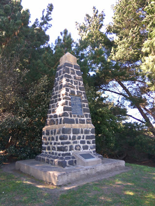
Near the beach, I walked past this monument which is honour the pioneers who arrived on the ship, Magnet, in 1840.
Waikouaiti has it's share of interesting letterboxes and these are some of the ones that I walked past today. I particularly liked the bagpipe playing letterbox.
Distance walked: 12.9 km Walking time 2hr 25 mins
Total distance: 758.2 km
Total walking 142 hr 09 mins


