Friday, October 22, 2021

Day 101 Roseneath

 I enjoyed my walk exploring the streets of Roseneath tonight.  I walked 9 streets tonight.

1343. Reeves Street
1344. District Road
1345. Downes Road
1346. Prospect Row
1347. Clyde Street
1348. Shandon Street
1349. Cove Street
1350. Fraser Street
1351. Kilgour Street

The suburb of Roseneath is on a promontory hill jutting into the Otago Harbour with great views in all directions.  I started my walk by looking towards Sawyers Bay and Port Chalmers.  Both suburbs that I have not walked yet.

And then as I walked further around the streets of Roseneath, I was able to look down the harbour towards the city.

Another view opened up as I continued walking around the streets.  I was rewarded with a great view across the harbour to the triangle shape of harbour cone and the hills of the peninsula.

On the forth side of Roseneath, I had a good view looking over farmland towards Mihiwaka which was covered in cloud. 
Some of the houses have the waters of the harbour across the road with great views looking at Port Chalmers. 

The railway line runs through a tunnel under Roseneath and I was lucky enough to see a train on the line heading towards the tunnel while I was standing here.

 I saw two interesting letterboxes during my walk in Roseneath.  I think the wonky triangle letterbox is supposed to represent a wave as it is outside a house which is across the road from the harbour while the tree letterbox is large and solid looking


The map below shows the streets in Roseneath that I walked tonight.

Distance walked:  3.0 km         Walking time  38 mins   
 
Total distance: 825.7 km          Total walking  155 hr 01 mins 

Monday, October 18, 2021

Day One Hundred West Harbour

Time for an evening walk and back to finish walking the streets named after New Zealand birds along the west side of the harbour.  I walked 8 streets tonight.

1335. Robin Lane
1336. Ruru Avenue
1337. Stevenson Lane
1338. Tui Street
1339. Weka Street
1340. Wren Lane
1341. Takahe Terrace
1342. St Leonards Drive

By following the old road to Port Chalmers there is very little traffic and the views from  are pretty.  I could hear a lot of traffic on the faster highway below me but there were no cars on this part of the less used St Leonards Drive.

As I walked further around St Leonards Drive, I was able to look down on the highway with the railway line beside the road and the harbour entrance in the distance.
Of course the streets beside the harbour climb the side of the hill and I need to walk up and then down each street as they do not join at the top. 
And while the residents in this area need to negotiate steep, narrow streets each day, they are rewarded with fantastic views of the harbour and the hills of the peninsula. I was quite happy to have a rest at the top of each street to catch my breath and admire the view.
 
One of the good things about walking every street in Dunedin is that I come across unexpected views in places that I had never been before.  The views of St Leonards Park from this angle is one of those unexpected rewarding views of the peninsula hills and harbour cone with it's distinctive triangle shape.
 
There was one interesting letterbox on my walk today.  This one with the giraffe is cute and I wondered if it was called Harold. 

I walked past this cute house nailed to a fence between the road and highway.  It almost looks like a bird house but there are no openings for the birds and I am unsure why it has been placed on the fence.

I thought it was time to share another map.  The map shows only a small number of streets that I have walked with those streets that I have walked highlighted in red.  Currently I am walking the streets down the left side of the harbour. 
 

Distance walked:  4.1 km         Walking time  50 mins   
 
Total distance: 822.7 km          Total walking  154 hr 23 mins 

Sunday, October 17, 2021

Day Ninety Nine Wingatui

Having finished walking the streets in the suburbs on the outskirts of the city yesterday, I started walking the streets of Mosgiel.  I walked 9 streets today.

1326. Paterson Road
1327. Haggart Street
1328. Crossan Street
1329. Magazine Road
1330. Friends Hill Road
1331. Puddle Alley
1332. Henderson Street
1333. White Hart Lane
1334. Soper Road

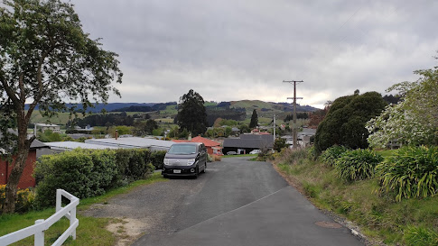
Mosgiel is a satellite town  of Dunedin with a population of over 14,000 people within the Dunedin City Boundary.  Mosgiel was founded in the early 1850's on the flat land of the Taieri Plains and while most of the town is flat, the eastern boundary runs along the low hills dividing Mosgiel from the rest of the city and this is where I started my walking today.  

 
Mosgiel is a growing town with a lot of new homes being built on the fringes.  Only a few years ago, most of this area was farmland.
The houses that have been built on the slightly elevated land of the hills have a view looking over the Taieri Plans and towards Three Mile Hill which is one of the main roads over the hill into Dunedin's hill suburbs.
Once off the slight hill, I was walking the long, straight streets on the edge of Mosgiel.  Because the streets are long and straight, I did not walk many streets although I did walk a reasonable distance today.

 
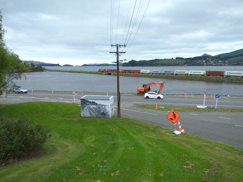
The road I walked along today runs beside the railway line.  This railway line travels the length of the South Island and I have crossed the railway line a number of times during my challenge to walk every street in Dunedin.

I walked past the Wingatui Railway Station on my walk today.  This station was opened in 1875 with this particular stating being built in 1914.  The station was closed in 1983 with both the station and signal box being preserved.  The inside of the signal box still has all the levers once used to manually change the track points.

But mostly the streets that I walked today were long and straight with only a few shorter side streets.

And to show that I did manage to walk some shorter streets, this is looking down Henderson Street from the railway embankment where there is a walking track beside the train track.  I walked one way along the footpath beside the road and then back along the embankment.

And at the end of the short streets was open farmland, which I am sure will not remain as farmland for long with all the new houses being built.  This will mean that in a few years, there will probably be new streets for me to walk. 

 
On the railway line embankment is this cleverly planted and maintained hedge spelling out the name of the suburb.  A popular myth for the name was when William Stevenson, an early settler in the area,  shot a Tui in the wing. Liking the sound of “Wing-a-tui”, William Stevenson named his property Wingatui in the mid 1850’s or the name could be the English spelling of the area which has the Maori name Whiringatua  meaning the place of plaiting of straps
These hens became excited as I walked past their home today, coming out onto the road to greet me and see if I had any food for them.

Distance walked:  7.8 km         Walking time  1 hr 26 mins   
 
Total distance: 818.6 km          Total walking  153 hr 33 mins 

Saturday, October 16, 2021

Day Ninety Eight Allanton, Momona & Outram

Today I decided to walk the streets of another three suburbs on the outskirts of the city.  I walked 29 streets today.

1297. Peel Street
1298. Ralston Street
1299. Grey Street
1300. Bardsey Street
1301. Precelly Street
1302. Ramsey Street
1303. Snowdon Street
1304. Caernarvon Street
1305. Hay Street
1306. Douglas Street
1307. Stack Street
1308. Castleton Street
1309. Ward Street
1310. Trigg Street
1311. Trent Street
1312. Holyhead Street
1313. Mountfort Street
1314. Franks Place
1315. Bidston Street
1316. Orme Street
1317. Railway Lane
1318. Bell Street
1319. Beaumaris Street
1320. Formby Street
1321. Rodeo Place
1322. Three Kings Court
1323. Lynas Street
1324. Skerries Street
1325. Hoylake Street

I started walking the streets in Allanton today which is a small township at the turnoff to the Dunedin Airport from State Highway One. I was surprised at the number of small hills that I walked up and down in Allanton

 
I have driven past Allanton many times but I had never walked it's streets before today and I found it be a pretty township with lots of green trees and shrubs. 
While there are quite a few houses in Allanton, there are paddocks alongside most houses which seem to have a few sheep or other farm animals. 
After walking the streets in Allanton, I moved onto the streets of Momona.  Momona is a small township on the edge of the Dunedin Airport and built on airport land.  There are three streets in Momona and they are all named after RNZAF airmen who received the Victoria Cross

The streets of Outram are wide, straight and flat with the hill of Maungatua behind it.  The name Maungatua is Maori and means 'Hill of the Spirits'.  

There is a lot of flat farmland surrounding Outram and the township is growing with new streets and new houses being built.  Today I walked a number of these new streets.
 
The streets of Outram run in a grid and I found that I needed to keep track of which streets that I had walked or I would miss completing some of them.  With the township being flat about the only hill I could see was Maungatua which dominated the view South.   

As Outram is close to the Taieri River, along one side runs the floodbank which protects the township when the river floods. Built around 1986, access to the floodbank is from the ends of some of the streets.
While there is no vehicle access on the floodbank, there is a walking track that is a popular walk, taking in farmland on one side and houses on the other. 

I walked past some interesting letterboxes today.  My favourite of the day is the Minion which is as large as a child. 


I saw quite few different animals during my walk today.  Apart from disturbing lots of dogs, I saw horses, sheep, a goat, pigs and two alpacas.


Distance walked:  14.5 km         Walking time  2 hr 47 mins   
 
Total distance: 810.8 km          Total walking  152 hr 07 mins 

Friday, October 15, 2021

Day Ninety Seven St Leonards

The weather has kept me from walking over the past week or so but I was able to get back out again today.  I walked 11 streets.

1286. Kea Street
1287. Finch Street
1288. Burkes Drive
1289. Moa Street
1290. Kaka Road
1291. Korimako Street
1292. Kiwi Street
1293. Huia Street
1294. Gannet Lane
1295. Hawk Lane
1296. Harrier Road

Tonight I walked along the road from Maia to St Leonards which used to be the main road to Port Chalmers.  Built in the 1860's this road connected Port Chalmers to Dunedin.
 
The railway line between Dunedin and Port Chalmers was built in the 1870's and as the township of Port Chalmers grew the faster harbourside road was built in 1965.
As I walked along the side of the harbour, I was rewarded with fantastic views looking across to the hills of the peninsula and Macandrew Bay
 
A lot of the houses in St Leonards are rewarded with great views looking down the mouth of the harbour and Harbour Cone which is the triangle shaped hill on the right. 
My walk tonight wasn't just along the flat as there are a number of steep streets in St Leonards that I walked up.  My reward for walking up the steep streets was getting a good view of Harbour Cone and the hills of peninsula as I walked back down.
During my walk tonight, I saw a train on it's way to Port Chalmers.  There has been a cycle/walkway has been built along the side of the railway line.  

Along the side of the Burkes Drive are the Halo Project traps.  I have walked past these traps in other parts of the city and each time I am reminded of what a great job these traps and the people who check them are doing to protect in helping to make predator free. 

Distance walked:  7.1 km         Walking time  1 hr 24 mins   
 
Total distance: 796.3 km          Total walking  149 hr 20 mins 

Otago Harbour Cycleway 30 October 2023

With my sister in town, it seemed a shame to waste a calm, sunny day so the two of us hopped on a bike each to enjoy the recently opened 32k...