Saturday, February 27, 2021

Day Thirty Four Town Belt

It's been nearly a week since my last walk of the city streets but back walking today with my goal being to walk all of the town belt.  Today I walked 6 streets. 

447. Queens Drive
448. Montpellier Street
449. Lane End
450. Braid Road
451. Duchess Avenue
452. Bute Street

The Dunedin Town Belt is over 200 hectares of native bush across several suburbs in central Dunedin.  It is one of only three Victorian Town Belts in the world.  The town belt is a good example of what Dunedin would have been like before the first settlers arrived and started cutting down the bush to build their homes.  Today the town belt is an important habitat for many birds including the kereru, tui, bellbird and rifleman.  It was a pleasure to hear many birds on my walk today

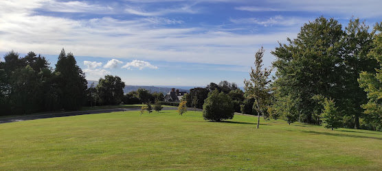
Queens Drive is the road that runs the length of the town belt and as it is narrow and windy, there is little traffic making it a great place to walk.  I started my walk on Queens Drive  from Eglington Road, Mornington and walked all the way to Prospect Park, Maori Hill.  There are open grass areas in the town belt giving the opportunity for views of the city.  

During my last walk, I walked past the front of Otago Boys High School today I walked past the back of the school.

The next bit of Queens Drive past Otago Boys High School is busy I walked past the city's public swimming pool.  Moana Pool was opened in 1964 and was one of the countries first Olympic sized swimming pools.  In the early 2000's the hydro slide was added.  

It was good to get past Moana Pool and back into the quiet and the green of the town belt.  The town belt has a number of walking tracks through the bush making it popular with walkers and runners. No  cars passed me during my walk today. 

As Queens Drive traverses a number of suburbs, the views of the city kept changing .  The residents of the houses that border the town belt are very lucky to have this quiet, green space so close. 

As I neared the end of Queens Drive, I came across a gap in the trees allowing me a great view of the University of Otago campus with all it's tall buildings and the stadium and harbour behind it. 

Once at the end of Queens Drive, it loops around the playing fields of Prospect Park giving great views down to Leith Valley and over to Pine Hill, North East Valley and Opoho.  I have not walked any of these streets yet and looking at them today,  I can see that I still have quite a few hills to walk up. 

I really enjoyed my walk of the town belt today and there were a few interesting things I noticed along the way. I came across this lovely big tree with it's commemorative stone telling how William Thomson had planted it and many others in the town belt from 1888 to 1923.

I also passed this old style post box outside Olveston.  It is one of only a few of it's type remaining in New Zealand

 It is great to see families making use of the green spaces along the town belt with areas for children to play. 

Distance walked:  8.0 km      Walking time  1 hr 32 mins    

Total distance: 291.2 km       Total walking  54 hr 36 mins


Sunday, February 21, 2021

Day Thirty Three Roslyn

Today I finished a number of streets that I had already walked most of and have already counted so there weren't many streets to count today.  I walked 6 streets

441. City Road
442. Ross Street
443. Stuart Street Extension
444. Strathmore Crescent
445. Erin Street
446. Sligo Terrace

Today I walked past the Observatory in Ross Street, which was established in 1922 by the Dunedin Astronomical Society and is named after local astronomers Arthur Beverly and John Campbell Begg,  The observatory is open to the public on Sunday nights.

The observatory is in Robin Hood Park which is on the edge of the Town Belt and my walk down City Road took me down the hill and through the Town Belt.

I walked part of Arthur Street and past two schools.  The first is Arthur Street School which is the oldest primary school in Otago.  The school was started on the Phillip Laing which is one of the first sailing ships to arrive in Dunedin in 1847.  Once in Dunedin, the school was opened at a waterfront site in 1848 before being moved up the hill. Arthur Street School moved to it's present site in 1877.  

Next door to Arthur Street School is Otago Boys High School.  Originally known as Dunedin High School and opened 1863, Otago Boys High School moved to it's present site in 1885 making it one of New Zealand's oldest boys secondary schools.

From Arthur Street, I turned the corner and walked up the Stuart Street Extension to the Roslyn Over Bridge which was constructed in 1954.  The views from the over bridge make the climb up the Stuart Street Extension worth the effort.  

From the over bridge I walked back through the Roslyn shopping area and down Erin Street which is a narrow one way street that comes out on Sligo Terrace.  The view from the Sligo Terrace playground  looking towards Mt Cargill was also worth taking the time to stop for.  

Today on my walk I saw this memorial in the Arthur Street Playground, beside Arthur Street School.  I found it particularly interesting is that, what is now a playground was the first cemetery in Dunedin.  The first burial on this site was in 1846 and as the city grew quickly, the site became unsuitable for a cemetery and in 1865 the cemetery was closed with the remains being relocated.  This memorial was erected in 1880 and has the names of around 60 known burials at the site, many of them are children who died at sea on their way to New Zealand. 

The other interesting thing I noticed about the Arthur Street Playground is the size of the trees. They are huge! Records show that the trees were planted around 1870.  This picture shows the size of one of the trees compared to the memorial in the bottom left corner.


Distance walked:  5.0 km      Walking time  57 mins    

Total distance: 283.2 km       Total walking  53 hr 04 mins


Wednesday, February 17, 2021

Day Thirty Two Kaikorai Valley

Today I was back walking in Kaikorai Valley completing all the streets up to Stuart Street, where I finished yesterday.  Today I walked 15 streets.

426. Manchester Street
427. Ipswich Street
428. St Albans Street
429. St Albans Close
430. Glenelg Street
431. Lixmont Street
432. Hector Street
433. Hermond Street
434. Frasers Road
435. Coleridge Street
436. Malta Street
437. Hereford Street
438. Kaikorai Valley Road
439. Oates Street
440. Falcon Street

Kaikorai Valley Road is about 6km end to end and since I had walked about half of it, today I had plans to finish walking all of it.  The first street off Kaikorai Valley Road that I walked today was Manchester Street which wound it's way uphill and gave me good views looking along where I was headed on Kaikorai Valley Road.


Further along Kaikorai Valley Road I walked up Glenelg Street and it was great looking back at the streets on the top of the hill where I had been only yesterday. You can see the top of the church I mentioned yesterday and the houses below the church are on Northview Crescent while the houses on the hill straight above the street I am walking are on Pitcairn Street, which is where I had been walking only a couple of days ago.  

 
It wasn't long before I was walking Frasers Road which leads to Frasers Gully.   The gully follows Frasers Stream  through native bush up towards Dalziel Road.  There are a number of short walks in Frasers Gully that are popular with dog walkers and families.  At the start of Frasers Road is Ellis Park which are sports fields that can be busy with sport  at the weekends. . 
 
I continued walking along Kaikorai Valley Road until I reached Stuart Street then headed along Oates Street.  It was good to look towards Helensburgh with Flagstaff rising behind.  
 
As I walked further along Oates Street the view changed to looking towards Mount Cargill and the streets near my home.  I have not walked any of these streets yet. 

I also got to look down on Ellis Park where I had been earlier in my walk.  The fields of Ellis Park looked large when I was beside them and they also looked big from Oates Street

On the corner of Oates and Falcon Street  (I had walked the top of the Falcon Street yesterday) there is a plaque to commemorate the British Antartic Expedition of 1912 lead by Robert Falcon Scott and supreme sacrifice of Capt. Oates to the expedition.  Falcon Street is a very steep street and I was pleased to be walking down it. 


Today on my walk I saw some ducks in Glenelg Street and sheep in Frasers Road.  It is a bit unusual to see sheep in the middle of the city and this is the first sheep I have seen.


Today I also saw this cleverly painted telephone cabinet.  I am enjoying discovering all the painted telephone cabinets around the city. 


Distance walked:  8.6 km      Walking time  1 hr 35 mins    

Total distance: 278.2 km       Total walking  52 hr 07 mins


Tuesday, February 16, 2021

Day Thirty One Roslyn

 I enjoyed my walk today and despite being on the hill, it was reasonably easy walking .  Today I walked 16 streets.

410. Epsilon Street
411. Gamma Street
412. Northview Crescent
413. Delta Street
414. Beta Street
415. Belgrave Crescent
416. Lundie Street
417. Gowry Place
418. Ann Street
419. Charlotte Street
420. Sheen Street
421. Scarba Street
422. Leven Street
423. Kilgour Street
424. Lawson Street
425. Bruce Street

I started by walking along Highgate and the first point of interest I passed is the World Mission Society Church of God. This church was sold to a Korean religious group in 2012 after the Roslyn and Maori Hill parishes merged.  I have been able to see this church from many parts of the city and it was good to finally get to walk past it. 

From the church it wasn't far till I was onto Epsilion Street and then the next few streets followed on the Greek alphabet theme.  From Gamma Street, I walked along Northview Crescent, and the name suggests that there will be a good view and I am pleased to say that Northview Crescent has a great view of Wakari and Flagstaff.  I have not walked on any of these streets yet.

As I made my way along Highgate the streets became narrower as I  worked my way through the streets behind the Roslyn Shopping Centre.  Part of the shopping centre is the old Roslyn Fire Station which is no longer a fire station and has been converted to a coffee shop.  


Once past the Roslyn Fire Station I was walking the streets on the other side of Highgate where the residents get good views looking towards the harbour. 

As I neared the end of my walk I walked along Lawson Street which is a short street that borders the Belleknowes Golf Club.  It is worth stopping here as the views are superb.

There were a few interesting things I saw on my walk today.  I passed two painted telephone cabinets.  The first is this one at the top of Falcon Street which commemorates Robert Falcon Scott and the  British Antarctic Expedition that he led to the South Pole 


And there is this telephone cabinet painted in commemoration of Dunedin becoming a UNESCO Creative City of Literature.  The people painted on the cabinet are writers and poets who had a connection with Dunedin at sometime in their life. 

I saw this lovely gate that matches the house behind it and I also spotted this sign that was awarded to  Highgate in 1994 for being the champion non-grass verge long street.  This is the first of these signs I have seen but then it is nearly 30 years old so maybe other winning streets have not kept their signs.


Distance walked:  9.2 km      Walking time  1 hr 44 mins    

Total distance: 269.6 km       Total walking  50 hr 32 mins


Saturday, February 13, 2021

Day Thirty Belleknowes

Today was another long walk with just over 2 hours of walking.  I walked 25 streets.

385. Jubilee Street
386. Longwood Avenue
387. Meadow Street
388. McCrea Street
389. Porteous Street
390. Parkhill Avenue
391. Hawthorne Avenue
392. Napier Street
393. Lonsdale Street
394. Preston Crescent
395. Belleknowes Terrace
396. Harcourt Street
397. Alison Crescent
398. Michie Street
399. Hart Street
400. Bellevue Street
401. Kenmure Road
402. Carnavon Street
403. Bright Street
404. Granville Terrace
405. Newport Street
406. Rosebery Street
407. Ashley Street
408. Beaumont Road
409. Pitcairn Street
 
I started by walking the streets at the back of the Mornington shopping area which took me down Meadow Street to join onto Hawthorne Avenue close to the town belt.  The town belt is a 'belt' of native bush in the central urban area of Dunedin covering over 200 hectares..  There are a number of walking trails through the town belt and I took one of these to Belleknowes Terrace to continue my walk. 
 
The residents of  Belleknowes Terrace and Harcourt Street are lucky having the town belt just across the road as, having such a beautiful patch of native bush so close is almost like an extension of their garden.
 

 Along with the trees of the town belt there is also some open green spaces and the views across these are worth stopping to enjoy. 


I came across this comfortable, concrete seat which was perfect to sit and enjoy the view from.  The seat dates back to1919 and was placed here by Tomas Brown who was the co-founder of the Dunedin Amenities Society whose aim is the protection and enhancement of the the Town Belt since it's foundation in 1888.


Once past the Town Belt, I was into walking the surrounding streets.  Some of the streets are very wide and there are good views looking down to the harbour.

Pitcairn Street was the last street I walked today and it gave me good views down the other side of the hill, looking towards Kaikorai Valley and the streets I had walked last week. 

The interesting things I saw on my walk today was this bee friendly section of the berm.  It was useful as well as decorative by having a large artichoke plant and rose bush planted at the base of this pole.  The bees were loving it!

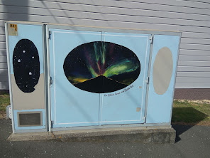
I passed two painted telephone cabinets today.  The first is a greyhound cabinet painted in memory to a much loved pet while the other is if the Aurora over Saddle Hill.  


And finally, today marked a couple of milestones for me - I have walked over 250km and more than 400 streets.   This is the map showing the streets (in red) that I have walked so far (does not include Middlemarch and Aramoana)
 

Distance walked:  10.9 km      Walking time  2 hr 03mins    

Total distance: 260.4 km       Total walking  48 hr 43 mins


Day Twenty Nine The Glen

 I was back walking on the hills today and walked 14 streets

371. South Road
372. Eglinton Road
373. Walter Street
374. Patrick Street
375. Elbe Street
376. Neidpath Road
377. Dalry Street
378. Cochrane Street
379. McGeorge Avenue
380.  Peel Street
381. Aitken Place
382. Glen Road
383. Reynolds Street
384. Hayward Street

The first street I walked today was to complete South Road.  It was good to look back around the hills where I had walked already.

After completing South Road, it was up the hill on Eglington Road and I walked the streets on the left of Eglinton Road.  I had a good view from Walter Street and it was a good feeling to know that I had walked all the streets that I could see. 

After Walter Street, I was back onto Eglinton Road and enjoyed the walk past the rugby field because I had fantastic, uninterrupted views looking towards the harbour. 

At the top of Eglington Road I was back at the Mornington shopping area where I had been a couple of days ago.  I then headed down Peel Street where I had a good view looking towards the streets I had walked yesterday (in the rain) 

My next task was to complete the streets that joined up to where I had been yesterday.  Then it was back down the hill on Glen Road to where I had started.  

I saw a couple of interesting things on my walk today.  The first was this painted telephone cabinet which is painted in Otago colours (blue and yellow) to represent a crowd on the terraces at the 'House of Pain' , the (now demolished) Carisbrook Stadium which was just around the corner from this telephone cabinet.


 An unexpected sight was near the end of my walk in Glen Road was this sad, unloved old Dunedin trolley bus.  Trolley buses were a common sight on Dunedin streets when I was child and it looks like this bus has been here a very long time. It is hard to see but there is a for sale sign in the front window but I had the feeling that this bus is too much part of it's surroundings to be moved.


Distance walked:  10.0 km      Walking time  1 hr 57mins    

Total distance: 249.5 km       Total walking  46 hr 45 mins


Otago Harbour Cycleway 30 October 2023

With my sister in town, it seemed a shame to waste a calm, sunny day so the two of us hopped on a bike each to enjoy the recently opened 32k...