Monday, July 10, 2023

#69 of 100 trips for 100 years - Gold Miners Direct - Possum Hut - Green Hut Site - Green Ridge 9 July 2023 (by Jade Pettinger)


It’s not often it is wetter in town than in the Silver Peaks, but somehow that is what happened today! Despite the pouring rain, nine of us showed up at Woodhaugh, huddling under an umbrella in a futile attempt to stay dry. I’m sure each of us was contemplating our decisions at this point and wondering why we had traded in warm fires and cosy houses for a day out tramping. After a brief discussion it was decided that albeit the less than ideal conditions, we would attempt the original plan of Possum Hut, mostly because “that’s how we do it in the OTMC”.

We bundled ourselves into cars and hit the road north with the window wipers on full speed. So, you can imagine our surprise when we reached the top of the motorway and all of a sudden had no need for window wipers! While the weather wasn’t clear, there was no water coming out of the sky so we took that as a positive sign. The carpark on Mountain Road was shrouded in thick mist, the ground was wet but there was not even the slightest drizzle!

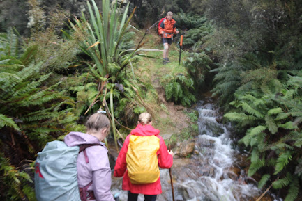
We set off down the Gold Miners Direct Track in good spirits, our jackets were only required to shield us from the dripping trees. The zig-zag track downhill to the South branch of the Waikouaiti River was in relatively good condition, with a few signs of the wild pigs that roam the area. The sodden ground was a bit slippery in places but these sections were easily navigated with the help of good tread, sturdy poles and well-placed trees. On tracks like this, it is always a good idea to have someone in front of you so you can watch where they step and if they slip you will know where not to put your feet.
Before we knew it, we were emerging from the dense bush to a small clearing at the bottom of the hill. With our raincoats still dry, we decided this was a good spot for a quick bite to eat. The mist made for quite an eerie atmosphere as it danced around the surrounding ridges, giving us glimpses at the towering hills above us.

From here, we took a left along an undulating path towards Possum Hut. We soon had our first major obstacle to negotiate - a tributary of the South Branch of the Waikouaiti River. This is usually a docile stream where you can jump across with dry feet, however after the recent heavy rain, was now a raging torrent that required consideration and caution to cross safely. One by one we carefully picked our way across, taking care to ensure we had solid footing with each step so as not to be swept away.
Having made it safely across, we turned our sights to Possum Hut, which for most of us, was our first time visiting this historical hut. About five or so minutes before the hut, we came across a plaque on the side of the track which was placed in 1952 by local farmers, Joe Clark and Phil Powell.
We didn’t have high expectations for Possum Hut, which was just as well as when we approached it soon became apparent just how derelict the hut has become. While no one knows exactly when the hut was built, it is believed to have been in the 1930’s with the possibility of gold in the nearby rivers causing excitement. However, this never eventuated too much and the hut soon fell into disrepair. Nowadays, the iron clad hut is covered in rust and slightly falling to one side. It is no longer watertight, and unless it was an emergency I doubt it would be anyone's first choice for overnight accommodation.
After exploring the historic hut, it was time to tackle the steep climb out of the valley. From here the track abruptly climbs straight up Possum Ridge to link back up with Green Ridge. It was a real slip and slide going up, most of us took a fall on at least one occasion as the ground just slipped away beneath our feet. Our hands were soon rubbed raw from grabbing onto tree branches and roots to help drag us up the slippery slope. Stopping for a breather was out of the question as we needed our momentum to keep us going forward, so we forced our burning legs to carry us upwards.
Thankfully the steep section was short and sweet and the track was soon levelling off, providing us with a much needed break to strip layers. The mist was thicker up on the tops, but we were still dry. After a gentle amble along the ridge, we soon joined up with the Green Ridge Track, where we made our way down to Green Hut Site for an early lunch.
We all enjoyed chatting and eating while making use of the newly installed seats, which the OTMC opened at King’s Birthday Weekend. We were soon on our way as we made our way down the very familiar track from Green Hut Site to Mountain Road as we have traveled along it many times during the 100 Trips.

written by Jade Pettinger


Friday, July 7, 2023

#68 of 100 trips for 100 years - Abbots Hill Loop (Friends Hill Rd - Flower St - North Taieri Rd - Abbots Hill Road) 2 July 2023


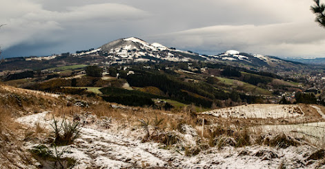
With snow on the hills and ice on the streets, it was a no surprise that only a handful of people were brave (or mad) enough to attempt today's trip.  Starting at Sunnyvale we slipped and slid our way along Main Road and then Flower Street before starting  our climb up the hill.  Once we reached the end of Flower Street, we left the houses behind and crossed a stile to wander through the farmers paddock while sticking to the paper road.  It was during this part of the journey that we started to encounter snow on the ground but the workout of walking uphill kept us warm.

 
Once across the paddocks we were onto Chain Hills Road where we really got to experience the snow with a blizzard of fat, fluffy snow flakes coming out of the sky.  It was about this time that we took the opportunity to duck under some low branches of a couple of large trees to shelter from the blizzard and enjoy a snack break. After the worst of the blizzard had passed,we emerged from our sheltered oasis to a winter wonderland covered in a white blanket. 

We followed Chain Hills Road to the end, then crossed another stile to continue along the Chain Hills Track following what, at first, appeared the obvious route but a layer of snow had covered the track making route finding a little difficult until a marker pole was spied and we were on our way again.  The views really started to open out behind us along this stretch of track with  Mosgiel on our left, Green Island/Abbotsford on our right and Saddle Hill/Makamaka directly behind us.
 

 From the Chain Hills Track we emerged onto Friends Hill Road which is another paper road and goes all the way to the top, climbing to 400m and Halfway Bush Road.  The gradient up the track is steady and we took our time, stopping often to admire the snow covered views behind us.  The snow became thicker with each step higher and the odd small snow flurry added to the experience but the climb uphill kept us warm.
We reached a patch of pine trees that had created a sheltered spot on the track and paused for a lunch break out of the snow.  Lunch was a reasonably hurried affair as we cooled down quickly now that we had stopped walking and the sky looked to be getting darker with another blizzard threatening. Back on the upward journey and we soon warmed again with the top of the hill beckoning us on.
There was a cold wind at the top of the hill so again, we didn't linger long and after congratulating ourselves for getting this far and knowing it was all downhill from here, we followed the Brinsdon Road track that connects up with Dalziel Road.  It was here we got hit by the full force of the blizzard as we were buffeted by head winds and horizontal snow before reaching the shelter of a line of huge trees where we were able to stop to catch our breath and shake most of  the snow off. 
From the tree tunnel the road drops steeply down to the next paper road, Abbots Hill track but first we had to dodge a surprisingly large amount of traffic that were on a joy ride to see how deep the snow on the hill suburbs was.  The limited visibility from the blizzard and dodging the joy riders made this the most dangerous section of the walk but by listening out for the traffic and keeping to the edge of the road, we made it safely to Abbots Hill track.
The Abbots Hill track proved to be the worst section of the day as the lower we dropped, the snow turned to rain and with the track being muddy and overgrown we put our heads down and continued downhill as fast as we could manage while staying upright.  It was during this descent that I began thinking about the different parts of the days walk - from icy streets, into snow covered paddocks, onto snowy roads and tracks before the wind and falling snow arrived and now the rain.  It had been a day of many parts and through it all I had remained warm and dry with my layers of clothing and only now were my feet starting to get wet as all the days moisture had started to soak through.  After dropping 100m down the Abbots Hill track we were on the sealed part of the road and it was an easy walk down to North Taieri Road and back to Sunnyvale just as the rain really started to pelt down. In total we walked 17 km over 5 hours with 450m height gain. 

#67 of 100 trips for 100 years - Orokonui Eco-Sanctuary Fence 1 July 2023 (by Jade Pettinger)


When I arrived at Woodhaugh on Saturday morning, I don’t think I quite realised what I had gotten myself in for. The plan for Trip #067 was to circumnavigate the fence surrounding the Orokonui Ecosanctuary - sounds simple enough, right? Unbeknownst to me (and many others on the trip), we would be faced with some of the steepest terrain encountered on the 100 trips so far…
The walk started off easy enough, a gentle stroll from the carpark at the Orokonui Lagoon to the base of the Ecosanctuary. Along the way we passed through many gates, a sign that we were entering the predator free zone managed by the Halo Project. On arrival at the fence we were greeted by two curious Takehē, who reside at the bottom of the Ecosanctuary. Takehē are an incredibly special bird - they were thought to be extinct for nearly 50 years before they were re-discovered deep in the Murchison Mountains in 1948. Since then, conservation efforts have seen their population increase to approximately 400 birds nationwide, and they are slowly being reintroduced into the wild. Takehē are classed as endangered, and are incredibly vulnerable to stoats and other predators - just one reason why the kaupapa and mahi of Predator Free Dunedin is so vital to protecting and preserving our taonga.
After much marvelling at the Takehē it was time to begin the climb. We opted to head left in a clockwise direction, as our leader Tina assured us it was much better to go up the steep section rather than down it. We were immediately greeted by a short but steep climb, which was made trickier by the thick loose gravel. It was like walking on scree - two steps forward and one back. Having tackled the first steep section, the track then immediately headed back downhill. Although we were dismayed to be losing the height we had just gained, we carried on happily chatting to those around us.
What we saw after rounding the next corner stopped us in our tracks and jaws dropped as we processed the sight in front us. Quite possibly one of the steepest tracks I have ever seen stretched out in front us as far as the eye could see. It was very quickly agreed that where we were standing was a good place for morning tea, but really we all wanted a chance to refuel and guzzle some sugar to prepare us for the relentless climb in front of us.
After mucking around handing out lollies and taking silly team photos, we realised we could no longer procrastinate. Gritting our teeth, we put our heads down and started walking. The excited chatter from before was replaced with heavy breathing, no one was wasting any energy on talking. Looking back was not for the faint-hearted as it appeared to be nearly a straight drop down to the bottom.
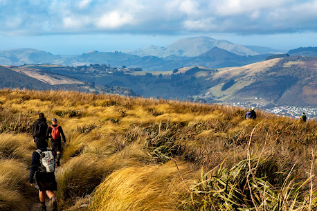
Thankfully it wasn’t long until the ground beneath our feet started levelling off and we were able to catch our breath. From hare, it was a gentle climb around to the entrance to the Ecosanctuary on Blueskin Road. We were treated to spectacular views in all directions on this stretch, from the distinctive ridgeline that makes up the backbone of the Silver Peaks on one side, to Harbour Cone and Sandymount on the Otago Peninsula on the other.
Some people treated themselves to a hot lunch inside the cafe at Orokonui - a rare treat on a tramping trip - while others opted to explore the area a bit and enjoy their kai al fresco. Did you know there is a flax plantation, otherwise known as a Pā-Harakeke at Orokonui Ecosanctuary? This is home to over 100 different varieties of harakeke (flax), which the public are welcome to harvest for weaving etc. provided appropriate tikanga is followed.

After lunch, it was a quick trip downhill towards the lagoon. This side was certainly not as steep, making it a very pleasant walk. The views over Blueskin Bay were gorgeous, and those of us with a keen eye enjoyed the light rays peeking through the clouds which made for a good picture. We made a brief stop to say hello to the Takehē before heading towards the cars, keen to get out of the biting cold wind and home safe before the forecasted snow arrived later that evening. 

 by Jade Pettinger

Wednesday, June 28, 2023

#66 of 100 trips for 100 years - Taieri River Track 25 June 2023


The Taieri River Track was opened in 2001 with the first OTMC trip to the track in 2002 and since then the track has been  a regular feature on theOTMC trip card.  Starting today's walk at sea level from Taieri Mouth were 16 people who wandered past some cute holiday cottages in the Taieri Mouth township before following the track alongside the wide, slow moving Taieri River.  With a near high tide, the water lapped at the edge of the track in places and in other parts there was some silty sand flats showing.
In the early stages of the trip, there was some jockeying for position as people found their walking rhythm and started to chat to the people in front and behind them.  The track initially winds it's way in and out of a number of small bays and with the native bush right down to the edge of the river, we enjoyed stopping to admire the wonderful views when able to get views of the river through the trees.    In places, the tidal nature of the river has created some lovely wetlands and boardwalks have been built to protect this fragile environment while also allowing us to get a closer view of the salt marsh.
After the first half hour of this easy walking, the track starts to climb, weaving in and out of a number of gully's as it steadily rises, eventually reaching a height of almost 200m.  At the highest point we are rewarded with a seat placed to make the most of the stunning views of the river, coastline and inland to the Silver Peaks. It was here that the unanimous decision was made to stop for morning tea to give us time to take in these wonderful views.
After all the effort of climbing to 200m from sea level, the track then drops steeply via zig zags over the next kilometre back to sea level.  John Bull Gully is a peaceful grassy cove in a bay on the edge of the Taieri River with a couple of picnic benches and is the perfect place for lunch while watching the river lazily flows past.  With the native bush coming all the way down to the rivers edge and reflecting in the dark waters of the Taieri River, it truly is a magical place to be. 
I can see that during the summer months, this would be a safe place for swimming and despite the sunny skies, the winter temperatures meant that no one wanted to take the plunge. There are some interesting headlands easily accessible from John Bull Gully and most of the group took the opportunity to explore as far as possible, taking care on the slippery rocks. 

There was some reluctance to leave after lunch as the track immediately heads steeply 200m up hill back to the lookout.  Everyone took the hill at their own pace and the climb did not take as long as first thought.  It helps that the native bush is so pretty, particularly with the sun shining through the canopy and highlight all the different greens, from lime through to the almost black.  Before we realised it we were back at the seated lookout.
An unspoken decision was made to stop here again to give us more time to enjoy the beautiful views set out in front of us. Despite the fact we had only had lunch not long ago, it was time to get the drink bottles and snacks out in order to delay our leaving as long as possible.
All good things must come to an end and eventually it was time to move on with a steady descent down the track as it winds its way in and out of the gully's.  The benched track is in surprisingly good condition for winter with very little mud and a number of steps making it easy to negotiate before reaching the rivers edge. 
Once at the rivers edge, it was a fast walk back to the start of the track at Taieri Mouth township.  All up we had walked 10.5km with a total of 400m ascent over 4.5 hours. 

Wednesday, June 21, 2023

#64 of 100 trips for 100 years - Nicols Creek - McQuilkans - Ben Rudd’s - Pineapple Track 18 June 2023


The trip had an unusual start as we stopped the car along the way to pick up a few stragglers who almost got left behind. This meant that once we reached the Nicols Falls car park, we had a few extra people than first thought.  In the end, there were 12 people keen for a fun day walking in the Flagstaff area under overcast skies.  We started by taking the Nicols Falls track which follows a wide graveled four wheel drive track before turning into a narrow walking track which climbs steeply as it winds it's way through native bush up the hill.  At the track junction we opted to visit Nicols Falls. 
From the falls, we crossed the creek and clambered up the benched track on the true left to gain the ridge and the Moon Track. The Moon Track has been enhanced by the mountain bikers with long sweeping bends, however we stuck to the Moon tramping Track which climbs straight up the ridge, crossing the mountain bike track regularly.  When crossing the mountain bike track, we kept an ear out for mountain bikers, however we saw no one so continued our climb, popping out of the bush to follow the fence line to the seated lookout without incident.
We stopped at the seated lookout for a brief morning tea break, however the cold wind meant we didn't linger long before packing up and continuing uphill on the Moon Track.  The views over the city from the seated lookout are spectacular of the city interrupted only by a small amount of cloud. 
Shortly after setting off from morning tea, the track enters the native bush again and we continued climbing up the Moon track.  After a short distance the Moon walking track continues to climb directly up the ridge, however we missed the turn off and followed the mountain bike track instead which wound it's way in and out the gully's following the contour line which added another almost kilometre or two to our journey.  At times the cloud rolled in and we walked in the mist, barely able to see the person in front and then the mist would clear and the world was revealed again.  As we left the bush and ventured into the golden tussocks on our approach to the summit ridge, 570m climb from where we had left the cars the cloud rolled back to reveal a blue sky albeit it with a cold wind.  
We had a second brief morning tea break sheltering amongst the tall tussocks with views overlooking the Taieri Plains and Mosgiel with Maungatua and the Silver Peaks in the distance.  Our second morning tea break was as short lived as the first because the cold wind meant that no one wanted to take longer than necessary and we were heading down the McQuilkans's track with the top part of the track.  The top part of the McQuilkan's track is in the open tussock but is also badly rooted over the wild pigs.
Not long after leaving the main ridge, the track re-enters the native bush, twisting and turning between large limbed, paper dripping fushia and tall, pencil thin, straight manuka trees.  The track crosses a couple of small creeks and through a number of extremely muddy sections before joining the Possum Busters track 200m below the summit.  We had thought to have lunch somewhere around this area but the muddy track and dripping wet bush didn't appeal so we continued on the Possum Busters track around to the bottom of the Jim Freeman track
This section of track had another couple of creek crossings with nicely placed stones to skip across, although some concentration was required to keep upright  and the feet dry as the stones were slippery.  There was also a couple of large muddy sections to avoid but otherwise we reached the Jim Freeman track unscathed.  If we had thought we had already done most of our climbing, however we were wrong as the Jim Freeman track climbs steeply 200m through native bush and Rhododendrons to the Ben Rudd Shelter which was the perfect spot to sit in the sun, out of the cold wind for lunch.
After a leisurely lunch, we continued another 60m uphill from the shelter to the Fire Break track where we stopped for a look at the recent Beech tree planting by the Ben Rudd's Trust.  Despite the cold wind we also took this opportunity to pick out the visible parts of the Silver Peaks including Pulpit Rock, Long Ridge, Powder Ridge and Silver Stream. 
From the Fire Break track, it was a short walk to the Cross Track and onto the Flagstaff Walkway with more fantastic views overlooking Dunedin City and the surrounding hills, including Kapukataumahaka/Mt Cargill, Herewaka/Harbour Cone and Poatiri/Mt Charles.  This has always been my favourite view of the city, however today we were buffeted by a strong, cold wind and, at times, it was hard to stay upright with the blustery wind trying to blow us into the tussock. 
Keeping our balance and pushing on, we skirted around the knob and down to the Pineapple Track where we ventured up to Pineapple Point before taking the Pepper Tree Track,  This track dropps sharply down 80m before entering the relative calm of the native bush before continuing on down a benched track through the bush and dropping 260m towards the road.  This was the drier, more sheltered side of the hill  and we were happy not to encounter any mud.
This section of track eventually joined up with the Nicols Falls track before reaching the road back at the cars.  It had been a fun day in the hills with around 900m of climbing and 13.5km taking us 5.5 hours of walking. 
 
GPS route of our trip


Otago Harbour Cycleway 30 October 2023

With my sister in town, it seemed a shame to waste a calm, sunny day so the two of us hopped on a bike each to enjoy the recently opened 32k...