The Milford Track was established in 1888 as a route between Lake Te Anau and Milford Sound and until 1959, the only way to and from Milford Sound was to walk both ways along the track. Named as 'the finest walk in the world', the Milford track was only accessible by paying for a guided walk until 1965 when the Otago Tramping Club refused to accept that only those who could pay were able to walk the Milford Track and a group of 40 people from the tramping club staged a protest or 'freedom' walk along the track. It was this freedom walk that opened the track up to non-guided walkers. As part of the Otago Tramping & Mountaineering Club's centenary project of 100 trips for 100 years it is appropriate that a group of 40 club members walked the Milford Track again.

The dates had been chosen 2 years earlier and it was with pleasure that the group of 40 club members, ranging in age from mid 20's to almost 80 boarded the ferry at Te Anau Downs in good weather to take us to the start of the Milford Track. The boat ride across the calm lake took around an hour and we were able to stand on the top deck and admire the mountains and fjords of the lake. The boat passed the Quinton MacKinnon memorial cross on a small rocky island in the lake which has been erected near where MacKinnon's boat was found after he went missing in 1892. Anticipation built as we neared the head of the lake and our journey on the Milford Track.

Once we docked at the start of the track and collected our packs, we began the first day's walk of one and half hours to Clinton Hut. The first 10 minutes is along a track wide enough for a four wheeler until we reached Glade House which is the first hut for the guided walkers. In 1928 the Otago Tramping Club walked the Milford Track and were present when the first Glade House was accidentally burnt down. Today Glade House is situated in a sunny clearing and has magnificent views of the surrounding mountains. We didn't have time to investigate further as we lined up to cross a large swing bridge over the stunningly clear green waters of the Clinton River

This first day saw us wandering along beside the Clinton River which is so clear that you can see the bottom no matter how deep and is an unbelievable green colour. The track is flat and easy to walk with lots of glimpses of the river and mountains. One highlight for me was stopping at a clearing with a good view of Dore Pass which is where I had come over to walk the Milford Track in 1988.
We took the short detour to the wetlands with wonderful red and orange mosses surrounding small shrubs which give the opportunity to appreciate the sheer sided mountains that enclose the Clinton River on both sides. Not far from the wetlands is our first hut, Clinton Hut which has bunks for 40 people and a large kitchen area. We found a bunk for the night and went for a short walk to a lovely swimming hole not far from the hut. It was a brief swim for those brave enough to enter the cold water and show some skin to the hungry sandflies but the views from the rivers edge are simply stunning.

Back at the hut we had tea and snuggled down for the night before an early rise in the morning for a 16km walk to Mintaro Hut. The track starts reasonably flat through the beautiful native beech forest dripping with moss which soaks up the rainfall in this, the wettest place on the planet but for us today, it was sunny and very dry making for good walking. Every few 100 metres or so is a glimpse of the clear green Clinton River and after a couple of short detours to viewing areas we emerged from the bush into the open valley.

From here the track became more interesting as we took all the side trips available. This included the 10 minute detour to Hidden Lake which isn't really hidden because of the sign pointing the way. With mirror like reflections in the calm lake we marveled at the sheer steepness of the valley sides and we discovered the only downside to having such fantastic weather is that there are no waterfalls. We all agreed though, that no waterfalls is a small price to pay for having beautiful blue skies. Another side trip was to Prairie Lake which was even lovelier than Hidden Lake, and that included the insect hidden in the cliff face (can you see it?)
We stopped for lunch at the Prairie where we met up with others from our group along with being discovered by the sandflies again. After the Prairie the track begins a steady climb towards Mintaro Hut with some sections requiring a rocky scramble while all around us, we were dwarfed by the rocky mountains and outcrops.
As we neared Mintaro Hut we started to get a closer look at tomorrow's obstacle, Omanui/MacKinnon Pass. Despite having done half the climbing to the pass already, it was still a daunting sight but our hopes were high for another cloudless day with stunning views.
With 20 minutes to the hut, the track starts to level off and we were able to pick up the pace a little. Arriving at the hut, we were greeted by three beautifully carved pouwhenua before climbing the stairs and finding our bed for the night. This is the new Mintaro Hut, opened only last year and is in a much better spot than the old hut. After dinner, we had a fun night with much hilarity when put into teams for a tramping related quiz night. Some teams did really well in the quiz, while others lack of knowledge was highlighted.

Knowing that the day going over Omanui/MacKinnon Pass was going to be the toughest day of the trip, we were up early and walking by 7.30am. The track up the pass zig zags it's way up, what from a distance, looks like a sheer rock face but in reality is a nicely graded track with the odd steep, rocky section. As we gained height, the trees started to become more stunted until we were out into the alpine tussock. We were lucky to come across a family of kea feeding their young on the track.

After an hour and half of steady climbing we came out on top of the pass to magnificent views on both sides. We rested for a few minutes by the MacKinnon memorial before exploring the area a little further. We felt privileged to be in this special spot on such a beautiful day, especially when considering that often the views are obscured by cloud as more than 9 metres of rain falls each year. We spent longer on the top of Omanui/MacKinnon Pass than we should have but we just couldn't drag ourselves away.
We were mesmerized by the many small tarns, surrounded by golden tussock on the pass with the reflections of the sheer rocky mountains on the dark watery surface. The view around each corner or knob we climbed over was breath takingly stunning. Eventually though, we couldn't delay any longer and we carried on to the pass shelter then started the 1000m descent down the other side.
The descent to Dumpling Hut is hard on the knees as it is mostly an alpine sidle over a rocky track then a scramble down over tree roots as bush line is reached. We found a sheltered spot beside a side creek for lunch which gave us cold fresh water. During lunch we spent our time admiring the views and looking back towards Omanui/MacKinnon Pass which looked almost vertical from this side.

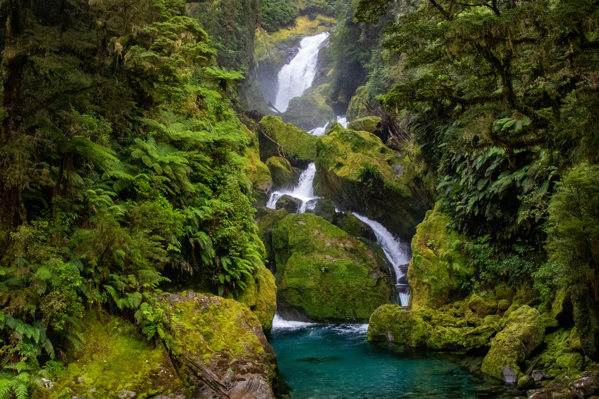
In the bush the track continued it's steep, knee jerking descent but with some nicely placed steps that took us close to the Roaring Burn which tumbled it's way down a number of waterfalls and rock faces. This was a nice distraction from the concentration needed for feet placement amongst the rocks and tree roots as we quickly lost height through the forest. The Roaring Burn is well named as it thundered beside us on and gave us the opportunity to rest and watch the water cascading down. After a couple of hours of knee jerking descent we rounded a corner to find we had made it almost to the bottom and there was the turn off to Sutherland Falls which is the highest waterfall in Australasia and the fifth highest waterfall in the world.

The side trip to Sutherland Falls is a 1.5 hour return walk over a small hill which is tough on already tired legs but it is also a must do so we left our packs and made the trek to the base of the falls. The sheer power of the water hitting the plunge pool at the bottom of the falls is unbelievable. A few hardy souls had braved the frigid waters to go for a swim while others donned their rain jackets to head behind the falls and it was fascinating to see how small they looked against the amount of water coming down the falls.

By now we were starting to feel tired and we still had a few hours of walking ahead of us so we didn't spend as long as we would have liked at Sutherland Falls and reluctantly we turned our backs to head back to where we had left our packs. Once back at our packs we had an hours walk to Dumpling Hut which was a sight for sore eyes as we had been on our feet walking for 11 hours. We found a bunk for the night and had a quick meal before thankfully rolling into our sleeping bags and were quickly asleep. The track from Dumpling Hut to Sandfly Point is reasonably flat and easy walking compared to the day before. We made good time, leaving the hut at 7am and walking to our first stop at the Boat Shed. This is where the first OTC group in 1965 had to cross a swollen river in flood but today there is a lovely big bridge across the wide, slow moving Arthur River for us to cross.

From the bridge we move away from the Arthur River and wind our way through the bush to the MacKay Falls and Bell Rock which is an enormous boulder that has been hollowed out over time by the power of water and then turned upside down. The hollowed out centre of Bell Rock is big enough to comfortably hold 5 people (or 15 at a squash).
We were very aware of the time as our boat was leaving from Sandfly Point at 2pm and we didn't want to miss it so we only had time for a few photos and a quick snack at MacKay Falls before hitting the track again. The track runs along side Lake Ada which is a large body of water formed by a landslide 900 years ago. Today Lake Ada looked peaceful and serene with swans and ducks floating on the waters surface. As we neared Sandfly Point we stopped for a breather at Giants Gate Falls.
We met up with a group of day trippers at Giant Gate Falls and we envied them their light, day packs but we only had a few kilometres to go and time was ticking so on we went, counting the mile markers as we passed them. By the time we reached Sandfly Point, the feet were starting to feel tired but we were happy to have completed the 53.5 km journey before the boat arrived.
Without a sign of rain at all over the last four days, we felt priviledged to have spent time in such a beautiful part of our country with a great group of people .


No comments:
Post a Comment